Fire Weather Risk Peaks This Week — And the Drought Isn't Done
A heat surge and critical fire weather conditions arrive Monday across Colorado — but the bigger story is what comes after: a pattern shift, a developing El Niño, and a water crisis that runs all summer.
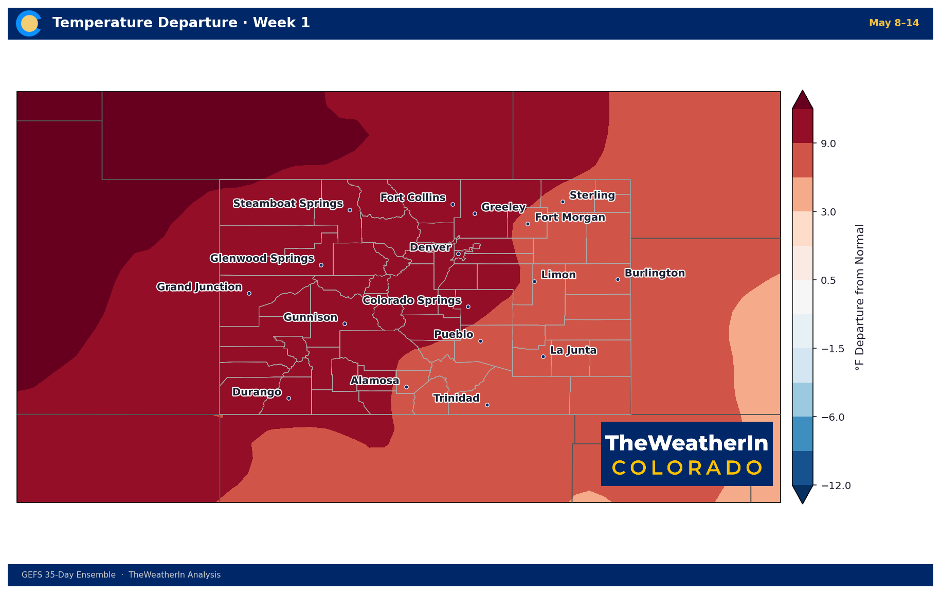
A strong upper-level ridge is pushing temperatures 15–25°F above normal across Colorado Monday through Wednesday, bringing critical fire weather conditions and the season's most intense heat surge — but this week's heat is only the latest chapter in a longer drought story that will define Colorado's water picture well into summer.
Pattern Overview
A broad dome of high pressure anchored over the western United States is the engine behind this week's heat. When the upper atmosphere buckles like this — building warmth and suppressing storm development — Colorado gets the full effect: compressed humidity, minimal cloud cover, and temperatures that can race past records on the plains and lower elevations. Denver could approach 90°F by Wednesday, and portions of the Western Slope are on track for record-high readings Monday and Tuesday. Relative humidity across mountain valleys and the northeastern plains will drop into the teens on the most critical days.
The ridge is not permanent. Forecast data shows the pattern shifting mid-to-late week as a trough approaches from the Pacific, nudging the ridge axis eastward and introducing increasing winds and some moisture by Thursday. That transition is welcome, but it should be understood for what it is: a moderation, not a reversal. Scattered mountain showers are possible late in the week, but the overall impact on precipitation is minimal. The soils, fuels, and reservoirs that have been stressed all season will not notice the difference.
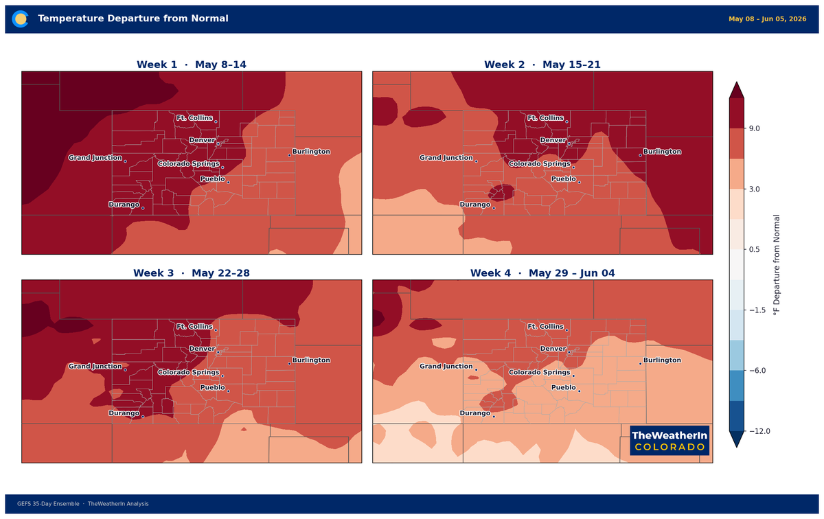
The larger driver worth understanding is the climate pattern that has been running Colorado's weather since late fall 2025. La Niña — the cooling of equatorial Pacific sea surface temperatures that tends to steer warmth and dryness into the southern Rockies — officially ended this spring. The transition to El Niño is expected this summer and fall. Historically, that transition loosens the dry grip on Colorado, but it takes months for the actual weather to materialize. May is not dramatically wetter yet, and the record-shattering drought that built through the warmest winter in Colorado's 132-year history is not unwinding on a human-relevant timescale this season.
Weeks Ahead: 2–4 Week Outlook
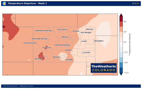
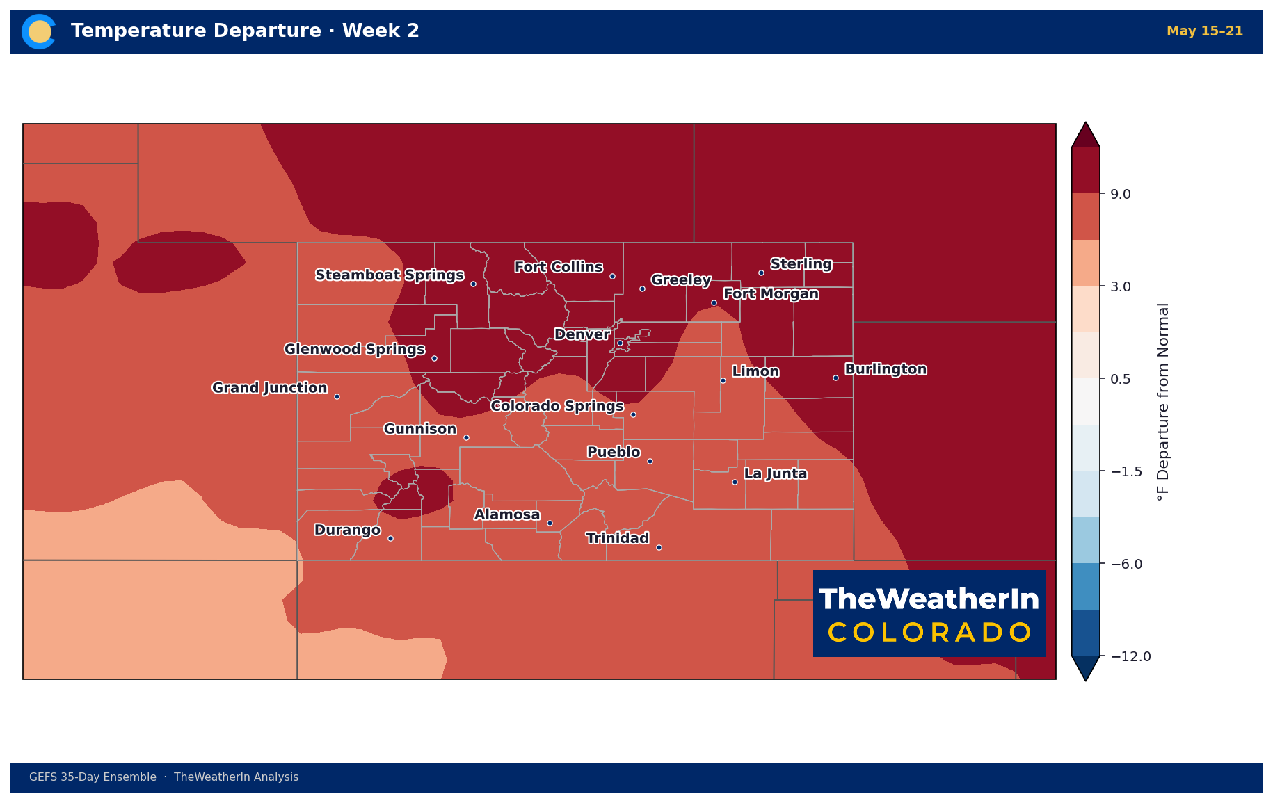
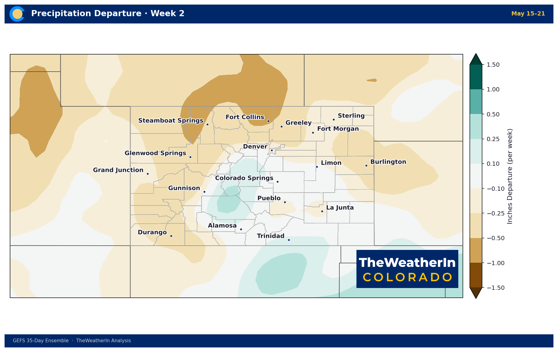
The dominant ridge over the western U.S. is expected to shift eastward during the May 17–23 window, a meaningful change after weeks of persistent warmth. As the ridge migrates toward the Plains and Mississippi Valley, Colorado should see reduced extreme heat and increasing chances for moisture advection and precipitation — particularly in the latter half of May. This is a genuine pattern signal worth watching, though the timing and magnitude of any precipitation remain uncertain, and temperatures are still expected to run above normal even as the extreme heat signal fades.
Beyond that, the broader seasonal context reinforces a gradual trend toward greater variability rather than a dramatic flip to wet and cool conditions. Forecast data for late May show an increasing probability of above-normal precipitation in parts of Colorado — a meaningful signal given where we've been, but not a drought-buster. The water supply deficit built up over the 2025–26 water year cannot be reversed by late-spring rain; what matters now is whether summer precipitation can begin to address soil moisture and fire-fuel conditions at the margins.
Regional Breakdown — Week of May 10–17, 2026
| Region | Temperature | Precipitation | Highlights |
|---|---|---|---|
| Front Range / Foothills | +15–20°F above normal Mon–Wed; moderating Thu | Minimal through Wed; isolated showers possible Thu–Fri | Highs in the 80s on the plains; RH drops to teens Mon–Wed; elevated fire weather daily; winds increase Thursday |
| Mountains / High Country | +15–20°F above normal through Wed; slight moderation Thu | Mostly clear through Wed; scattered diurnal showers Fri | Highs 50s–70s at elevation; fire weather conditions in mountain valleys Mon and Wed; late-week showers minimal impact |
| Western Slope | +15–25°F above normal Mon–Tue; record highs possible | Mostly sunny through Wed; a few showers over high terrain late week | Hottest region in the state; critical fire weather conditions isolated to scattered each day; Wednesday offers highest wind potential ahead of pattern shift |
| Eastern Plains | +20°F above normal by Wed; lows 90s possible | Drizzle early Sunday, then dry Mon–Wed; scattered showers possible late week, low probability | Most fire-weather-stressed region this week; received least precipitation from recent events; fuels critically dry |
| Southern Colorado / San Luis Valley | Above normal Mon–Wed; moderate warm anomaly | Drizzle/clouds early Sunday; dry Mon–Wed; a few mountain showers late week | Critical fire weather sporadic through Tuesday; more widespread potential Wednesday onward as winds increase; recent green-up may limit fire spread in some areas |
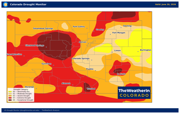
Drought & Water
As of May 5, 2026, every square mile of Colorado is in some level of drought. Extreme drought (D3) or worse covers 58% of the state; exceptional drought (D4) — the most severe category — covers nearly 18%. The Drought Severity and Coverage Index stands at 359, more than double its level at the start of the calendar year (127) and well above the reading from one year ago (140). Conditions improved slightly week-over-week from April 28 (DSCI 366 to 359), but that is a marginal shift against a historic backdrop.
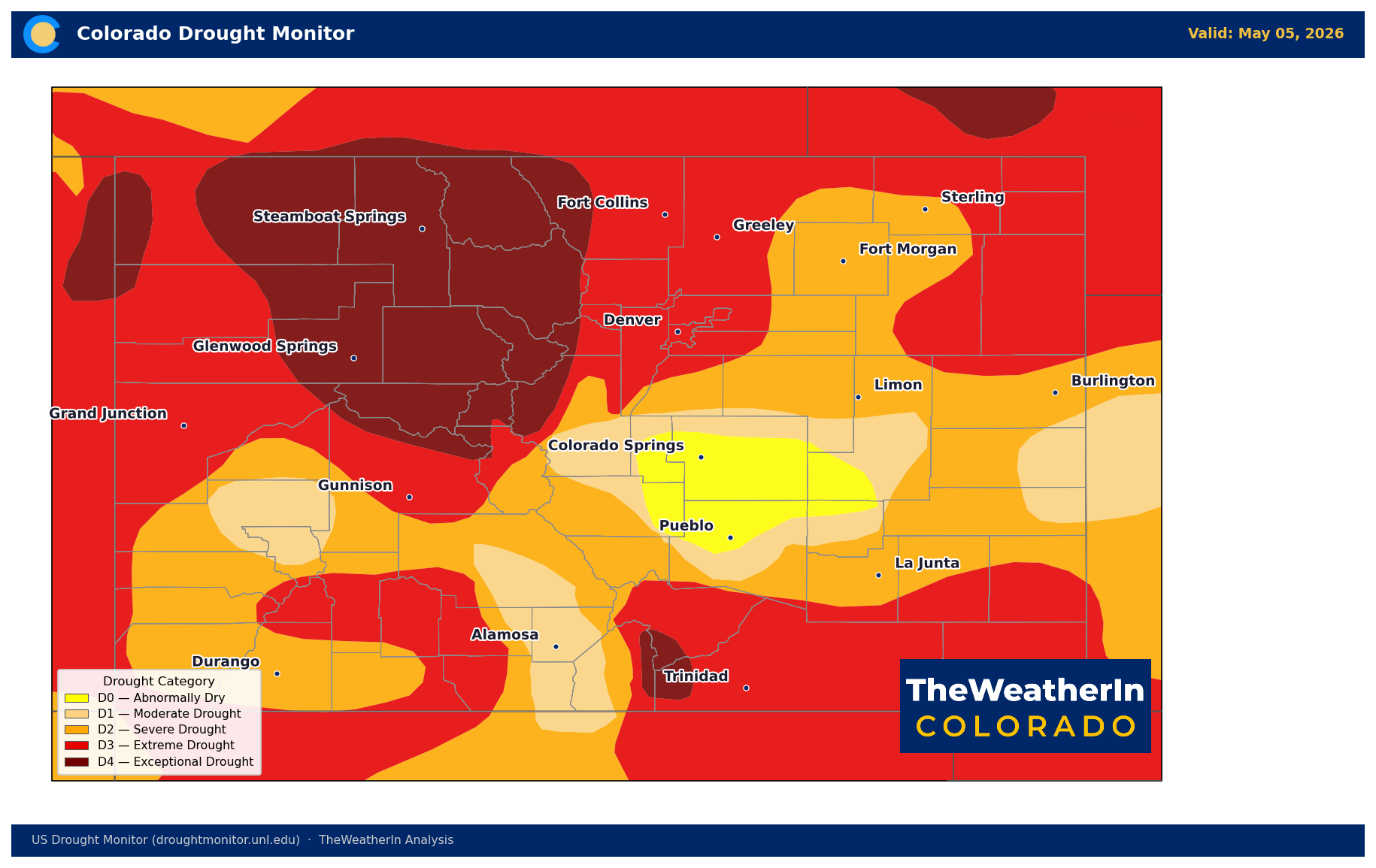
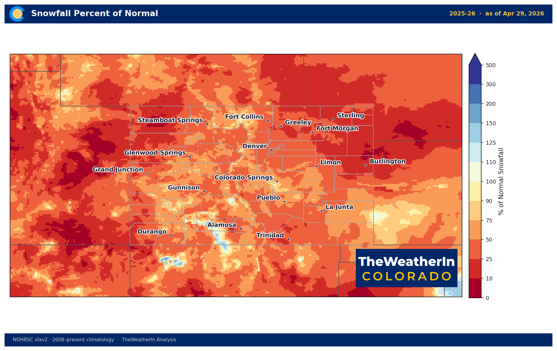
The drought's severity traces directly to the 2025–26 water year — the warmest October–April on record by nearly 3 degrees, and the seventh driest start to a water year in 132 years of records. Statewide snowpack as of May 1 sits at just 20% of the median — still the lowest on record for that date. The April 1 snow water equivalent of 1.66 inches was less than one-third of the previous all-time low. The mountains are essentially bare weeks ahead of schedule, and the spring runoff pulse has already peaked and is receding across most river systems.
Statewide May–July streamflow is forecast at just 24% of normal. Nearly half of all Colorado streamflow forecast points are on track for record or near-record low flows this season. Reservoir storage sits at 85% of the median statewide as of May 1 — a number that looks stable only because carryover from 2025 is masking the incoming deficit. As summer draws down that storage with no meaningful snowmelt replenishment coming, the gap will widen. This week's heat accelerates evaporation and deepens soil moisture deficits. Fire risk is the immediate consequence; water supply stress is the season-long one.
Agricultural Implications
- Heat stress on spring plantings: Highs 15–25°F above normal Monday through Wednesday will stress young cool-season crops and recently planted fields across the plains and lower elevations. The Eastern Plains approaching 90°F by Wednesday is notable for this point in May — plan for accelerated soil moisture loss and consider irrigation scheduling accordingly, where water is available.
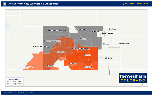
- Fire weather and rangeland fuels: Critically dry fuels across the Eastern Plains, San Luis Valley, and southern Colorado represent the most acute near-term risk. Elevated fire danger daily, Monday through Wednesday; the best windows for widespread critical conditions are Monday and Wednesday. Open burning is not advisable. Livestock producers should have evacuation contingencies in place.
- Dryland operations and longer-range soil moisture: No meaningful precipitation is forecast through Wednesday, and late-week mountain showers will not address the severe soil moisture deficit that has built since fall 2025. The water supply gap for the 2026 growing season is effectively locked in — even if late-spring precipitation runs above normal from here, it cannot replace the snowmelt-driven streamflow volume that was never delivered. Forage conditions on native pastures remain stressed across drought-affected areas; producers managing grazing rotations should plan for a shorter, drier-than-normal grass season.
The key signal to watch in the coming weeks: whether the pattern shift expected in the May 17–23 window delivers meaningful precipitation to fuel-stressed and drought-stressed areas of Colorado, and whether that moisture can put a dent in fire weather conditions heading into the peak of the season.