May Storm Brings Freeze Risk and Fire Danger
A late-season punch of snow, freezing temperatures, and extreme fire danger arrives this week — but the pattern potentially turns warm and dry again by month's end.

Colorado's late-season storms always arrive with an asterisk, and this week's system is no exception: heavy mountain snow and a hard freeze threat on one side of the state, extreme fire danger on the other — and a return to warm, dry conditions right behind it. The near-term swings are real, but the bigger story is the one that picks back up by the weekend and runs through the end of May.
Pattern Overview
A strong upper-level trough is sweeping across Colorado today, dragging cold air, moisture, and — critically — a sharp wind shift in its wake. The mechanics are classic late-spring Colorado: the trough's leading edge fires extreme fire weather conditions across the southern plains before the cold front clears, while the trailing cold air floods the mountains and foothills with heavy, wet snow. Behind the system, below-normal temperatures hold through midweek before a ridge rebuilds and warmth returns by Friday.
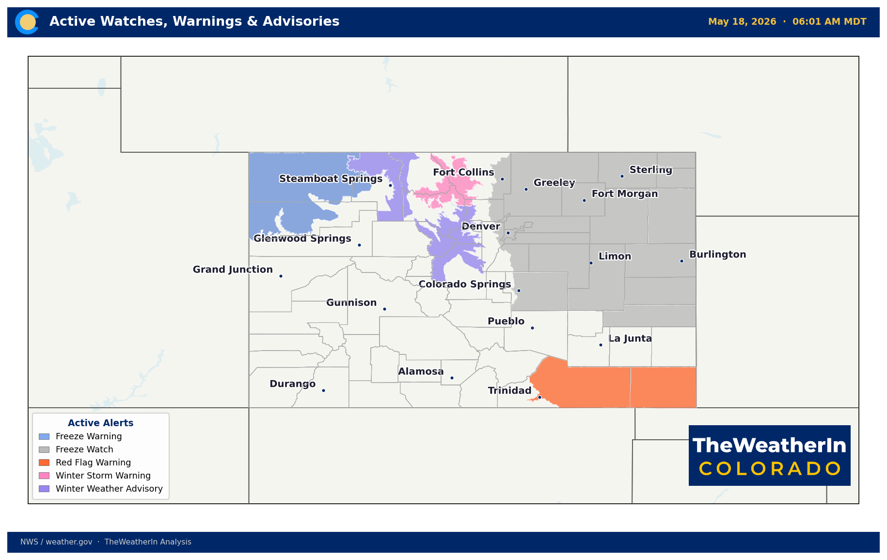
The reason the fire danger is so severe today — and the reason this freeze matters so much for agriculture — traces directly to the season that preceded it. Colorado has just come through the warmest water year on record by a wide margin. The record-shattering warmth of December, February, and March drove the lowest snowpack ever measured for this date, accelerated snowmelt by roughly six weeks, and left fuels across the Eastern Plains and southern Colorado critically dry heading into spring. Today's Red Flag Warning conditions in Baca and Las Animas counties are not a surprise in that context; they are the predictable outcome of a landscape that has been stressed all season.
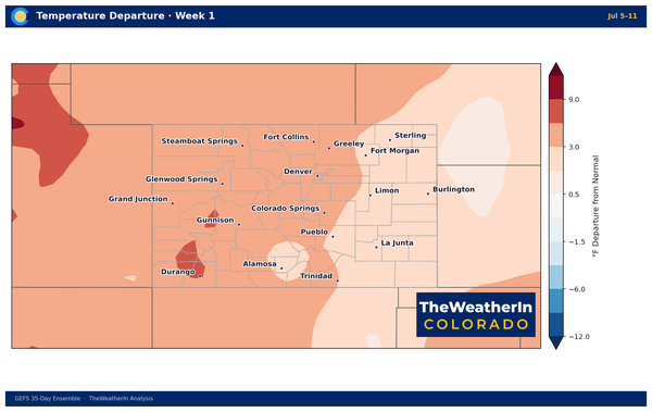
The cold air behind today's system provides real, though temporary, relief from fire weather. Minimum relative humidity values recover above critical thresholds Tuesday through Friday, and scattered afternoon showers and thunderstorms provide additional natural suppression. But temporary is the operative word. Forecast data through the end of May favors a return to above-normal temperatures and below-normal precipitation across Colorado's interior — the same warm, dry pattern that has dominated since fall 2025.
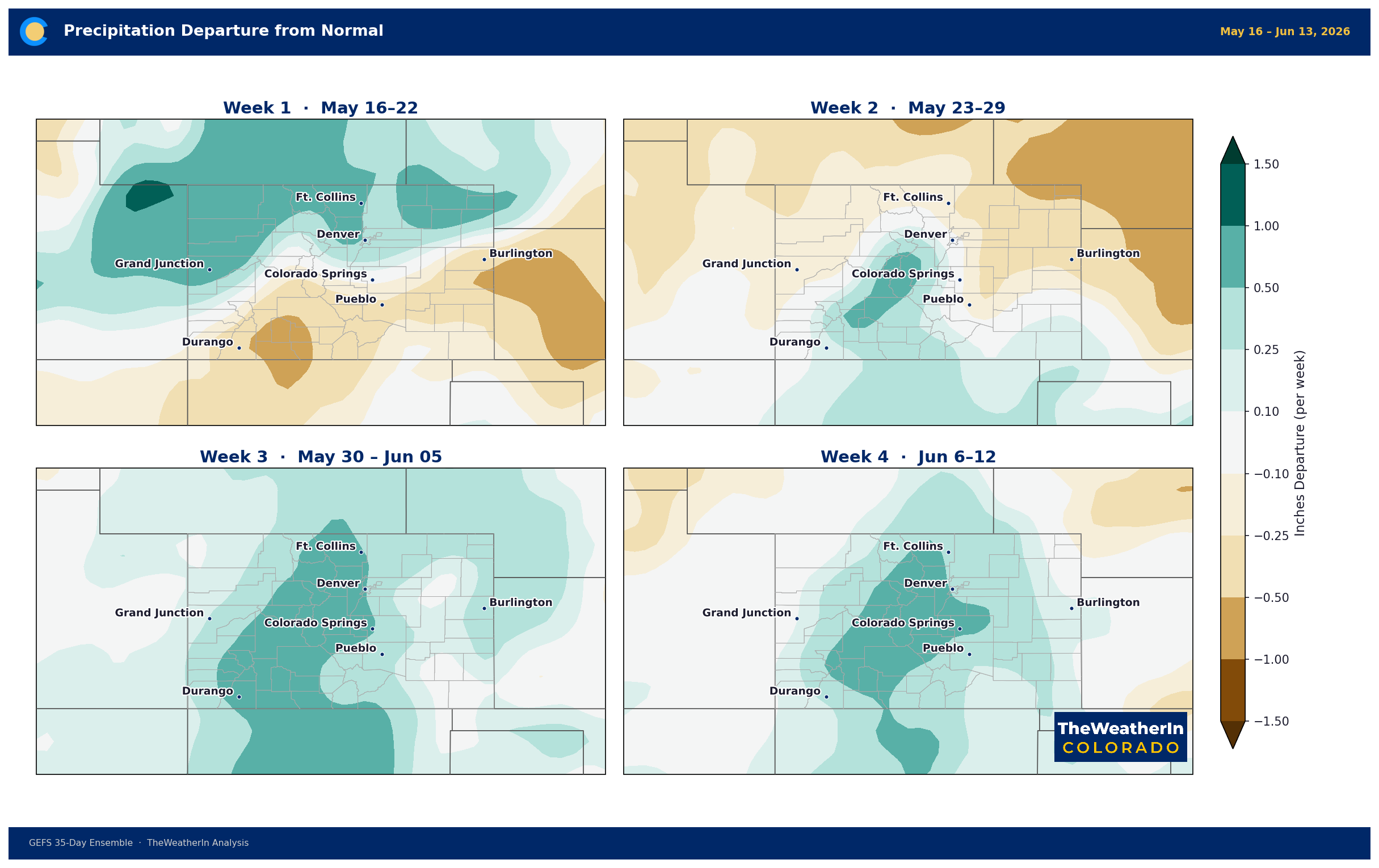
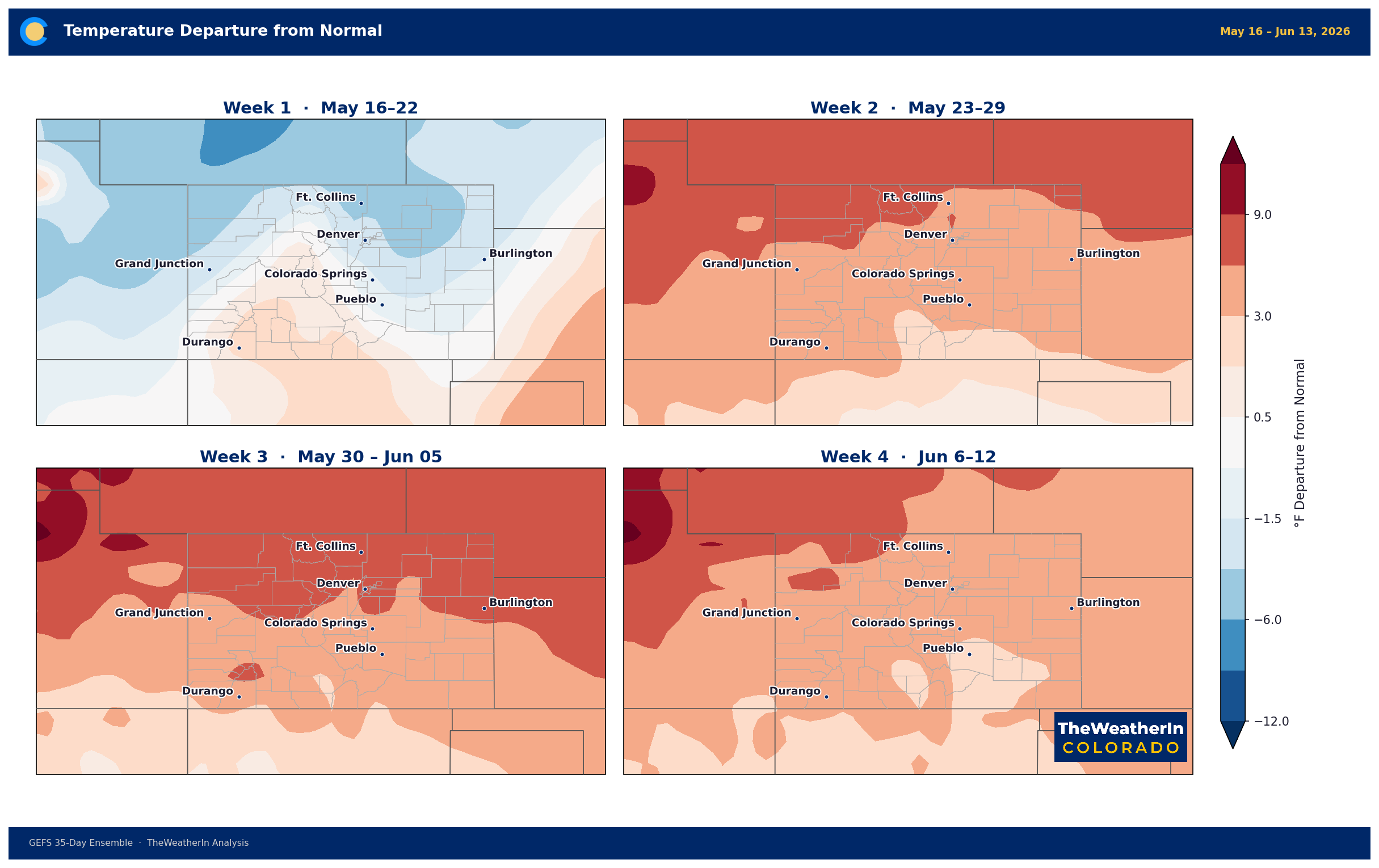
Weeks Ahead: 2–4 Week Outlook
The cool, active period this week is a brief interruption, not a pattern change. By late this week, the upper-level pattern transitions toward a flatter, more zonal flow, and temperatures rebound across the state. Forecast data for the period spanning roughly May 20–25 show a mainly dry signature across the interior West, with temperatures warming and returning to the Front Range and Eastern Plains by the weekend.
For the following week (roughly May 25 through May 31), our analysis points toward mid-level ridging asserting itself across much of the central and western United States. That means above-normal temperatures and drier-than-normal conditions for Colorado — the same pattern that has dominated in recent weeks. Any significant precipitation during this period is more likely to track into the Southern Plains and Southeast than across the Rockies.
Looking further out, the emerging story is El Niño. NOAA issued an El Niño Watch on May 14 — the tropical Pacific ocean is warming at depth, and El Niño is expected to emerge this summer with high confidence, persisting through the winter of 2026–27. Historically, El Niño winters bring above-normal precipitation to the southern Rockies, which is a meaningful signal for Colorado's water supply outlook. But that relief, if it comes, is months away — and strength remains uncertain. For now, the dry pattern runs the show through the end of May.
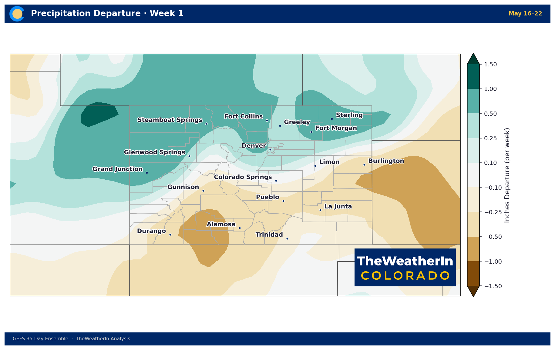
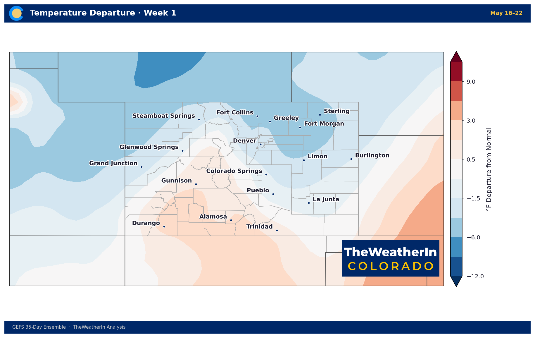
Regional Breakdown — Week of May 18
| Region | Temperature | Precipitation | Highlights |
|---|---|---|---|
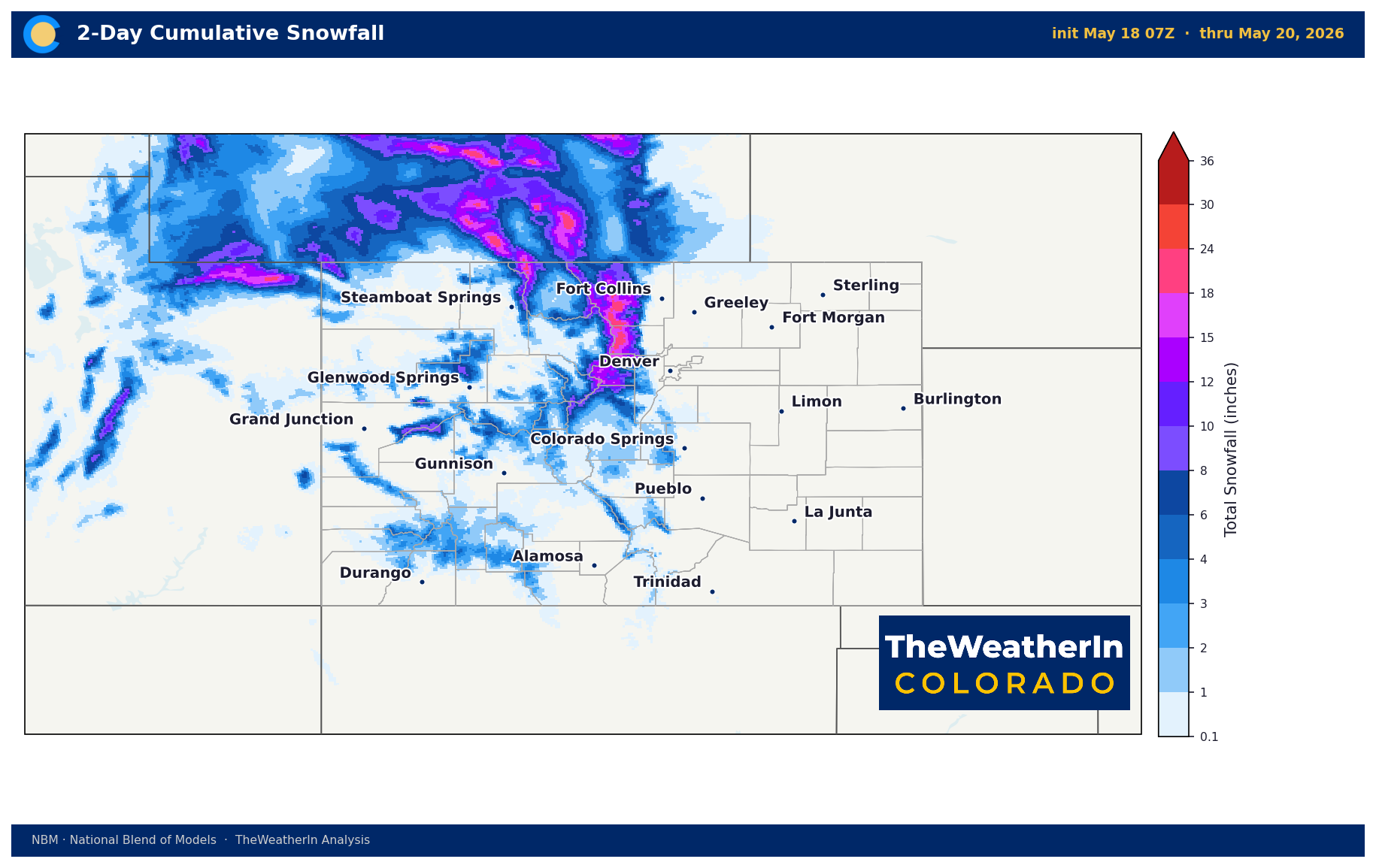
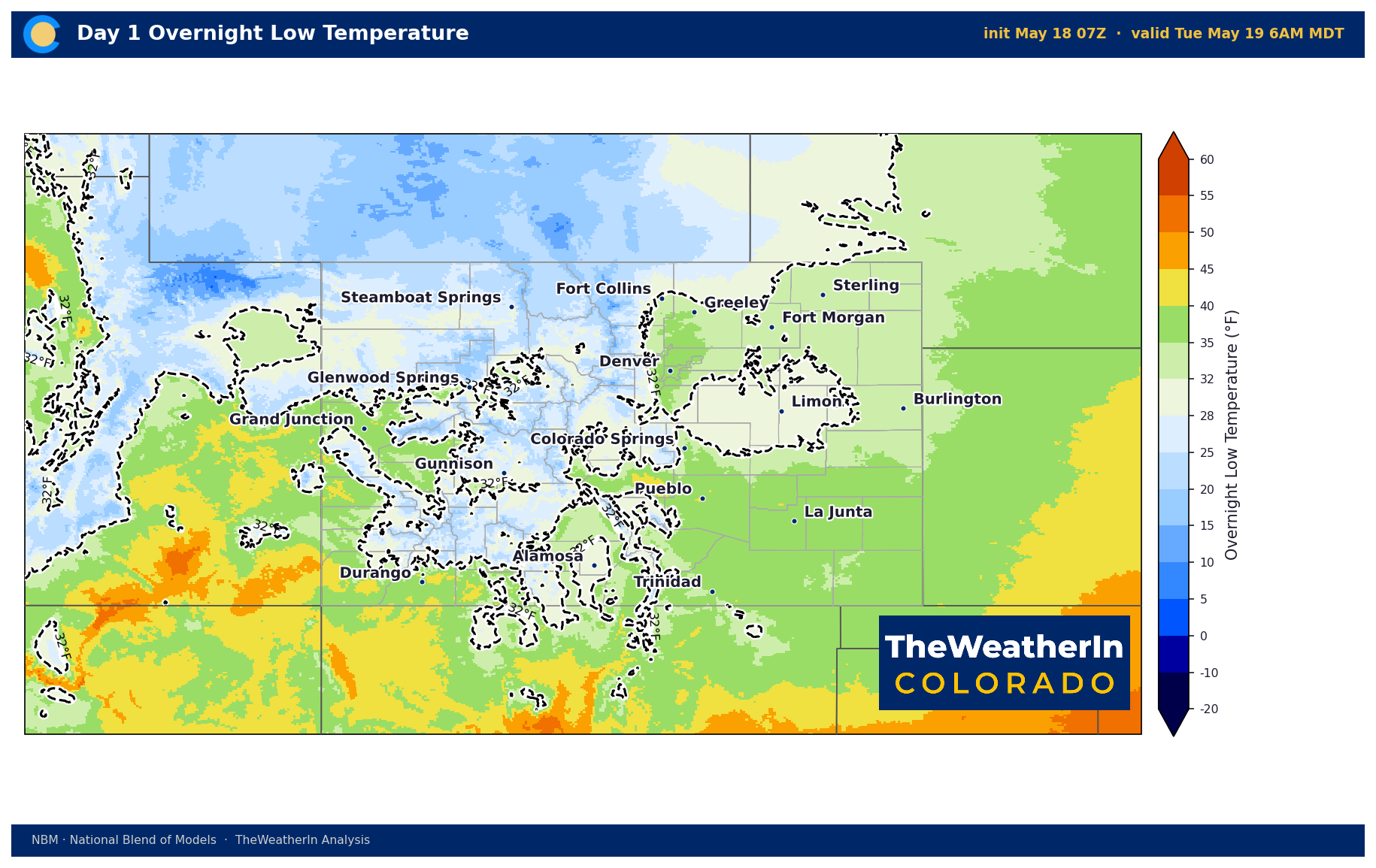
| Front Range / Foothills | 15–20°F below normal Mon–Wed; near normal by weekend | Rain today; scattered showers Tue–Thu; drying Fri–Sun | Foothills above 8,000 ft: 4–8" wet snow today. Hard freeze possible Monday night on the plains. Highs only 50–55°F Tue–Wed. |
| Mountains / High Country | Well below normal Mon–Wed; recovering Thu–Sun | 12–18" heavy snow on north-facing slopes above 9,000 ft today; blowing snow hazards; scattered showers Tue–Thu | Rabbit Ears Pass: ~50% chance of exceeding 6". Snow levels 6,000–9,000 ft. Freeze conditions Tuesday and Wednesday mornings in Yampa River Basin. |
| Western Slope | Below normal through Wednesday; warming returns Thursday | 2–6" snow at higher elevations; near a foot along US-191 (Uintas); clears by late Tuesday afternoon | Winter weather advisory through 9 PM tonight. Blowing snow on passes. Hard freeze Tuesday and Wednesday mornings in lower Yampa Valley. |
| Eastern Plains | 20–25°F below recent pattern Mon–Wed; recovering by weekend | Rain today; rain chances return Tuesday night into Wednesday | Red Flag Warning today (Baca, Las Animas counties) — 45–50 mph SW winds, single-digit humidity. Front clears after sunset. Hard freeze possible Monday night (El Paso, Kiowa counties); frost elsewhere on plains. |
| Southern CO / San Luis Valley | Below normal through Wednesday; near normal by late week | 2–4" wind-driven snow in San Juans and central mountains; system clears by midnight tonight | 50 mph winds with blowing dust today before frontal passage. Hazardous travel from blowing snow on passes. Cooler temperatures persist through Wednesday. |
Drought & Water
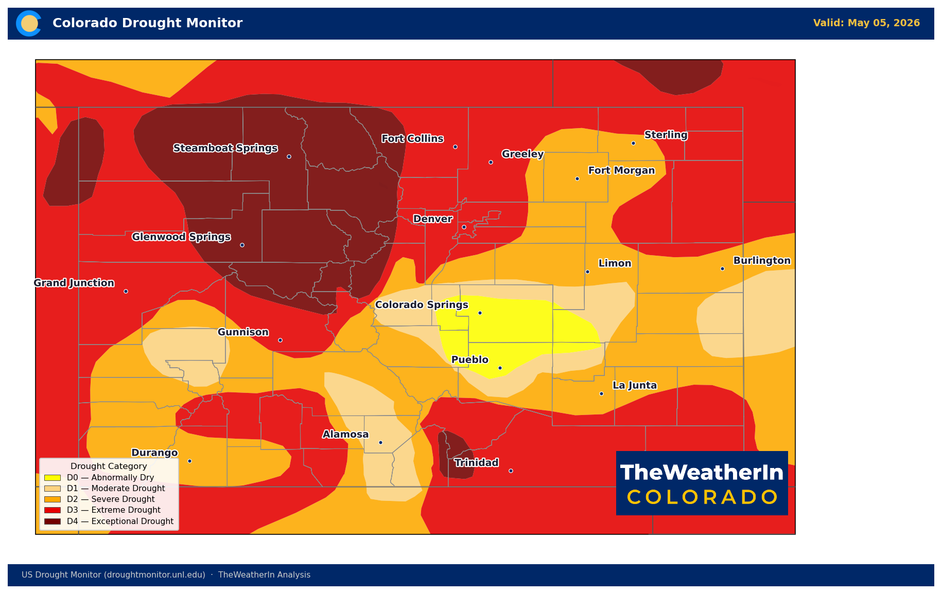
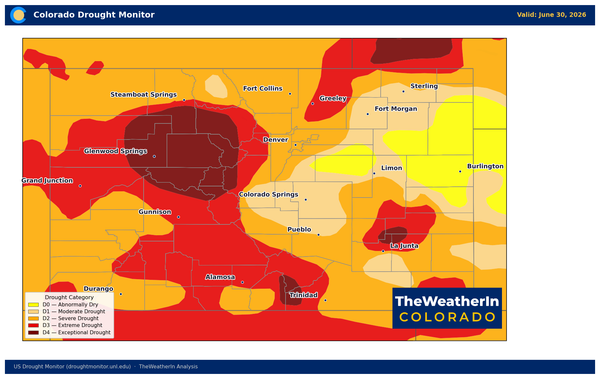
As of the May 5, 2026, 100% of Colorado remains in drought — with 96% of the state in moderate drought or worse, and 58% in extreme or exceptional drought (D3–D4). The statewide Drought Severity and Coverage Index sits at 359, a level that reflects how broadly and deeply the drought has embedded itself across the state over the past several months.
This week's precipitation — rain across the plains and lower elevations, snow in the mountains — will provide genuine, if temporary, surface moisture relief. Totals of 0.5 to 2.0 inches are expected statewide, which improves topsoil moisture and reduces fire weather risk through midweek. What it cannot do is address the underlying deficit. Colorado's statewide snowpack stood at just 20% of the historical median as of May 1 — the lowest on record for that date, and less than one-third of the previous all-time low set nearly fifty years ago. That snowpack was the state's water bank for 2026. It is already spent.
Statewide May–July streamflow is forecast at just 24% of normal. Nearly half of all Colorado river forecast points are on track to set record or near-record low flows. The Colorado River near the Utah border is forecast at 23% of a normal year — a shortfall of roughly 2.5 million acre-feet. Reservoir storage is holding closer to normal statewide, thanks to carryover from 2025, but that carryover is being drawn down, with little replenishment from mountain runoff in sight. The Eastern Arkansas basin is already the most stressed in the state at 56% of median storage and falling. This week's rain is welcome. It does not change the 2026 water supply picture.
Agricultural Implications
- Hard freeze risk tonight and Tuesday morning: Temperatures are forecast to drop to freezing or below across the Eastern Plains (El Paso, Kiowa, Baca, Las Animas counties) Monday night into Tuesday morning, with a second freeze possible Wednesday morning in the Yampa River Basin. West Slope fruit crops already sustained significant damage from an April freeze — any additional cold stress on emerging growth, row crops, or orchards warrants close monitoring tonight. Protect sensitive plantings where possible.
- Wind erosion hazard today: Southwest winds of 45–50 mph across the Eastern Plains and San Luis Valley, combined with critically dry soil conditions, create an active blowing dust and topsoil loss threat on unprotected fields ahead of the frontal passage. No tillage or soil-disturbing activity should be conducted today in affected counties.
- Surface moisture relief is real but brief: The rain and snow this week provide meaningful wetting across most of the state — the best moisture event in weeks for many areas — but soil moisture remains below normal at depth, and the longer-range outlook (warm and dry returning by late May and persisting) means this relief is a pause, not a recovery. Irrigation planning and dryland crop decisions should account for a return to moisture stress through June.
Watch the El Niño signal carefully through summer: if the developing El Niño strengthens through July and August, the probability of an above-normal precipitation winter for the southern Rockies improves — a meaningful, if distant, signal for 2026–27 water planning.