
Colorado Drought Update — June 2026: Conditions Hold as Summer Heat Builds
The brief improvement from May storms has stalled. Nearly all of Colorado remains in drought, and the DSCI is more than double last year's value. Here's where things stand and why summer won't change the trajectory.

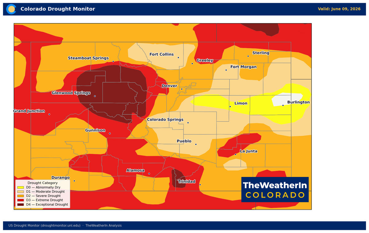
Colorado's Drought Barely Budges as Summer Heat Arrives
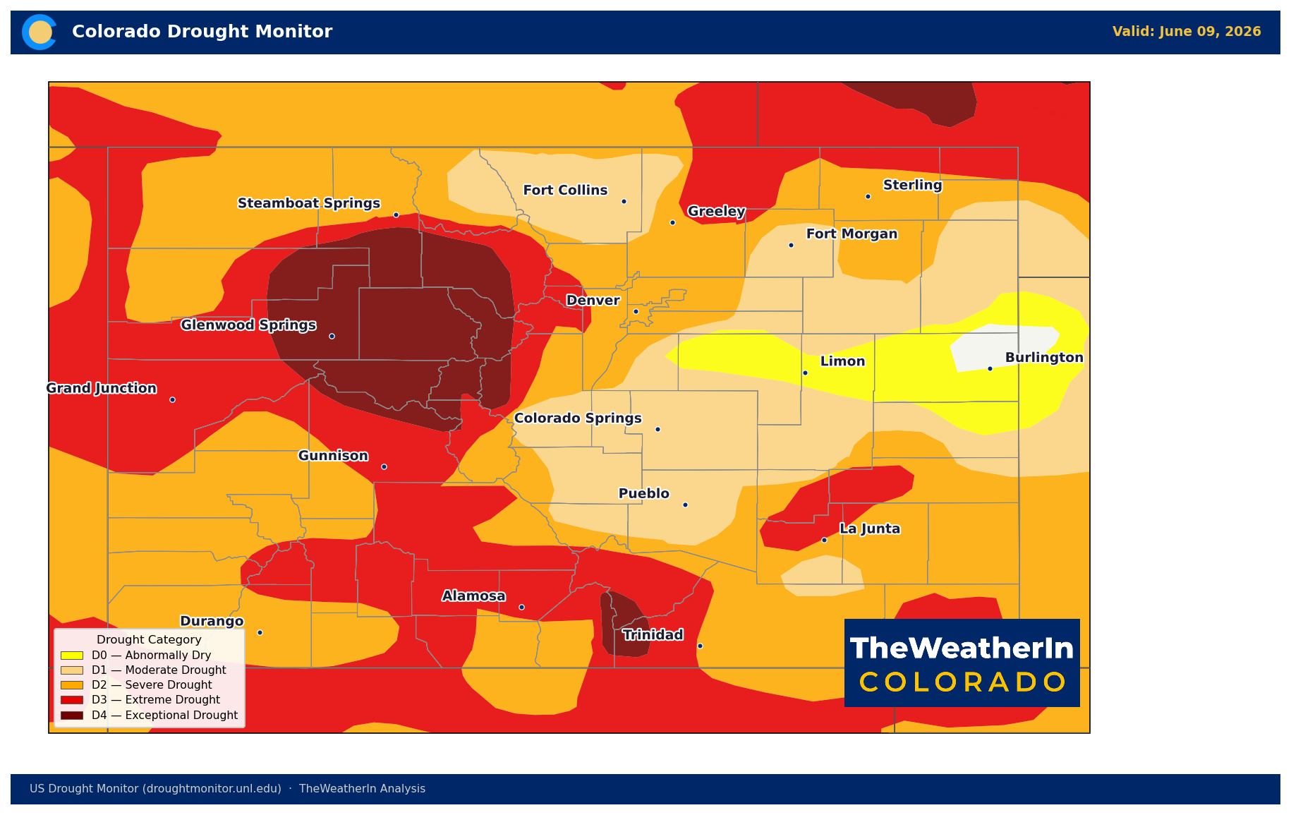
The latest drought map offers little encouragement. After May storms briefly pushed back extreme conditions across northern Colorado and the eastern plains — the first meaningful retreat in months — that progress has stalled. As summer heat builds across the state, conditions will only become harder to improve on their own.
Pattern Overview
The drought covering virtually all of Colorado was built last winter, when record-shattering warmth and a near-total absence of mountain snowfall combined to produce the lowest snowpack in recorded history. That deficit set the course for the entire water year. The May storms that drove extreme drought coverage from about 59% at the end of April to roughly 40% by month's end were meaningful — but not transformative. The snowpack window is closed, and summer precipitation, however welcome, cannot replace the mountain runoff that never arrived.
The near-term pattern isn't offering a break. A brief cooldown this weekend brings a small chance of showers Sunday and Monday — most areas will see less than a tenth of an inch, and the risk of dry lightning in the San Juans and along the Divide adds a new fire start concern even as storms move through. High pressure rebuilds by Tuesday, returning the hot, dry, and windy conditions that have become the default pattern for Colorado this spring and early summer. Critical fire weather is expected to persist through at least the week of June 15, and likely beyond.
Looking Ahead: The Summer Drought Outlook
The drought outlook through summer is effectively one of persistence. Summer heat increases evaporation and soil moisture demand, working against any precipitation that does arrive. The near-term pattern leans warm and dry across most of the state through late June, with no reliable signal for a sustained wet pattern. The one variable worth watching is Colorado's summer monsoon, which historically pushes north into southern Colorado and the San Luis Valley beginning in mid-July. A developing El Niño — now confirmed in the tropical Pacific as of the June 11 advisory — has historically increased monsoon moisture for the southern Rockies. But the monsoon's reach fades significantly north of the Arkansas River drainage, leaving the Front Range and northern and eastern plains largely on their own through summer.
Meaningful, widespread drought recovery for Colorado is a winter story. A moderate-to-strong El Niño — now the favored scenario, with a 63% chance of a very strong event by late fall — historically tilts the odds toward above-normal precipitation across the southern Rockies from November through March. That's the window worth watching, not the coming months.
Drought Conditions by Region
| Region | Current Intensity | Recent Trend | Key Concern |
|---|---|---|---|
| Front Range & Northern Plains | Severe–Extreme (D2–D3) | Improved during May; now stable | Streamflow well below normal; fire risk on dry/windy days |
| Southern & Eastern Plains | Extreme (D3) | Mixed; some areas worsening | Range and dryland crop stress; elevated fire risk continues |
| San Luis Valley & Southern Colorado | Extreme–Exceptional (D3–D4) | Worsening since end of April | Irrigation shortfalls acute; critically dry fuels; fire risk high |
| Western Slope & Four Corners | Extreme (D3) | Little change since April | Rivers at or near record lows; reservoir drawdown under way |
| Northern & Central Mountains | Exceptional (D4) | Unchanged; worst conditions in the state | Headwater flows at record-low percentiles; fire weather active |
Drought & Water: The Numbers
As of June 9, 99.45% of Colorado is in some level of drought. Moderate drought or worse now covers 95.26% of the state — an expansion from 92.66% the prior week, erasing a small portion of May's progress. Exceptional drought (D4) holds at 8.82%, concentrated in the north-central mountains and the Sangre de Cristo range. The Drought Severity and Coverage Index stands at 316 — more than double its value one year ago (132) and more than double the reading at the start of 2026 (127).
The streamflow data underscores the scale of the deficit. May flows across Colorado's major river basins were 20–39% of normal — the Arkansas Basin at 20%, the Gunnison at 26%, the San Juan system at 30%, the Colorado Headwaters at 35%. The Colorado River and Arkansas River were near record-low values at month's end, with records going back 93 and 117 years respectively. Statewide May–July runoff is forecast at just 24% of a normal year. There is no mountain runoff left to deliver.
Agricultural Implications
- Irrigation water remains severely limited across all major basins for the 2026 growing season. Producers dependent on surface water rights — particularly in the Arkansas, Gunnison, and San Juan drainages — are drawing on reservoir carryover from 2025 with no meaningful mountain replenishment forecast this season.
- Range and pasture conditions are deteriorating heading into the hottest months of the year. Below-normal soil moisture combined with summer heat stress is accelerating forage depletion on native pastures across the Eastern Plains and southern Colorado. Stock water sources in drought-stressed areas warrant close monitoring.
- Fire weather risk remains elevated across all drought-affected areas through summer. The fuel conditions that allowed the Sharpe Fire to burn 18,000 acres in Baca County last month have not improved — and summer is typically when those conditions are at their worst. Critical fire weather episodes will recur on days with strong winds and low humidity.
The drought story for Colorado this summer is not about waiting for conditions to improve — it's about managing through a historic deficit until the pattern shift that could finally make a difference has a chance to arrive. That chance begins, at the earliest, this coming winter.



