
Fire Weather, Fourth of July Storms, and a Drought That Isn't Done
Critical fire conditions through Friday, storm risks on the 4th, and a gradual moisture return — but Colorado's drought story is far from over.

Colorado enters the holiday weekend caught between two competing stories: critical fire weather that has no patience for Independence Day plans, and the first tentative signs of moisture returning from the south — a shift that matters, but one that won't touch the deeper drought this state has been carrying since last fall.
Pattern Overview
A shortwave impulse — a dip in the upper-level flow that triggers localized storm development — is crossing the Rockies today, sparking isolated to scattered thunderstorms mainly over the eastern plains and mountains. The more significant concern today and Friday is what's happening on the surface: a deepening low pressure system combined with strong southwest upper-level winds is driving relative humidity values into the single digits across southern Colorado, the San Luis Valley, and southwestern mountains. When air that dry moves at 25 to 40 miles per hour across fuels that haven't been this parched in a generation, the fire weather threat isn't hypothetical — it's immediate.
The heat driving this pattern is rooted in a persistent ridge of high pressure anchored over the Desert Southwest. That ridge has been the dominant feature of Colorado's summer so far — suppressing storm development, keeping moisture locked out, and baking a fuel complex that was already critically dry after the worst snowpack season on record. High temperatures of 100–105°F are forecast for southeastern Colorado and desert valleys through Friday, with the Grand Valley expected to reach triple digits by midweek next week as the ridge briefly reasserts itself.
The more hopeful signal arrives over the weekend: southerly flow begins advecting moisture northward from the Gulf, slowly increasing afternoon convection Sunday into next week. This is the beginning of a monsoon-like pattern setup, though "beginning" is doing real work in that sentence — the moisture return is gradual, confidence in rainfall amounts is low, and the areas most in need of relief (southeastern Colorado, the San Luis Valley, the Western Slope) are the last to see it. That said, the directional change is real, and it's the most meaningful pattern signal in weeks.
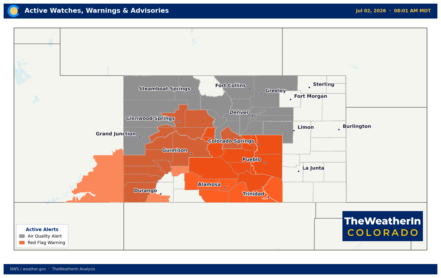
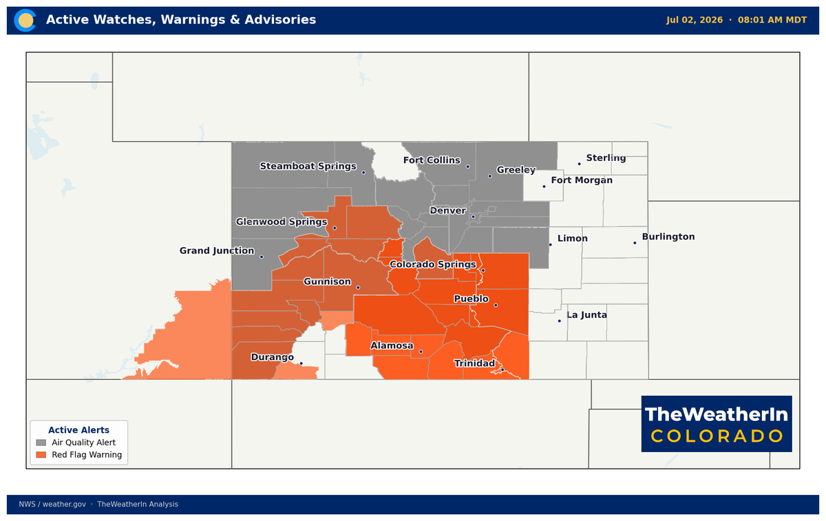
Active alerts across Colorado as of July 2, 2026. Red Flag Warnings are in effect statewide through Friday.
Weeks Ahead: 2–4 Week Outlook
The near-term fire weather threat transitions into a more active convective pattern through the second and third weeks of July. Forecast data shows a gradual increase in precipitable water — a measure of how much moisture is available in the atmosphere — with the strongest signal arriving in the week-two window, particularly for southern Colorado and the mountains. This doesn't guarantee wetting rains, but it does raise the probability of slower-moving, more organized convection that can deliver locally significant totals where it does occur.
Temperature-wise, the four-week outlook continues to lean above normal across most of the state, though the magnitude of the anomaly is expected to decrease from the extremes of late June and early July. The pattern driving that heat — a persistent ridge over the Southwest — is expected to relax somewhat by the third week of July, allowing increased storm activity to moderate afternoon highs. For drought relief purposes, the question isn't whether it rains, but whether it rains enough, consistently enough, over the areas that need it most.
The longer-range picture — the one that actually moves the needle on Colorado's drought — remains a winter story. El Niño conditions are now confirmed in the tropical Pacific, and the outlook has shifted toward a moderate-to-strong event this coming winter, with a strong possibility of an event that ranks among the largest in the modern record. That's a meaningful signal for Colorado's snowpack prospects next season. But that signal doesn't arrive until November at the earliest. Between now and then, summer convection is what Colorado gets, and summer convection is a highly local, day-to-day proposition.
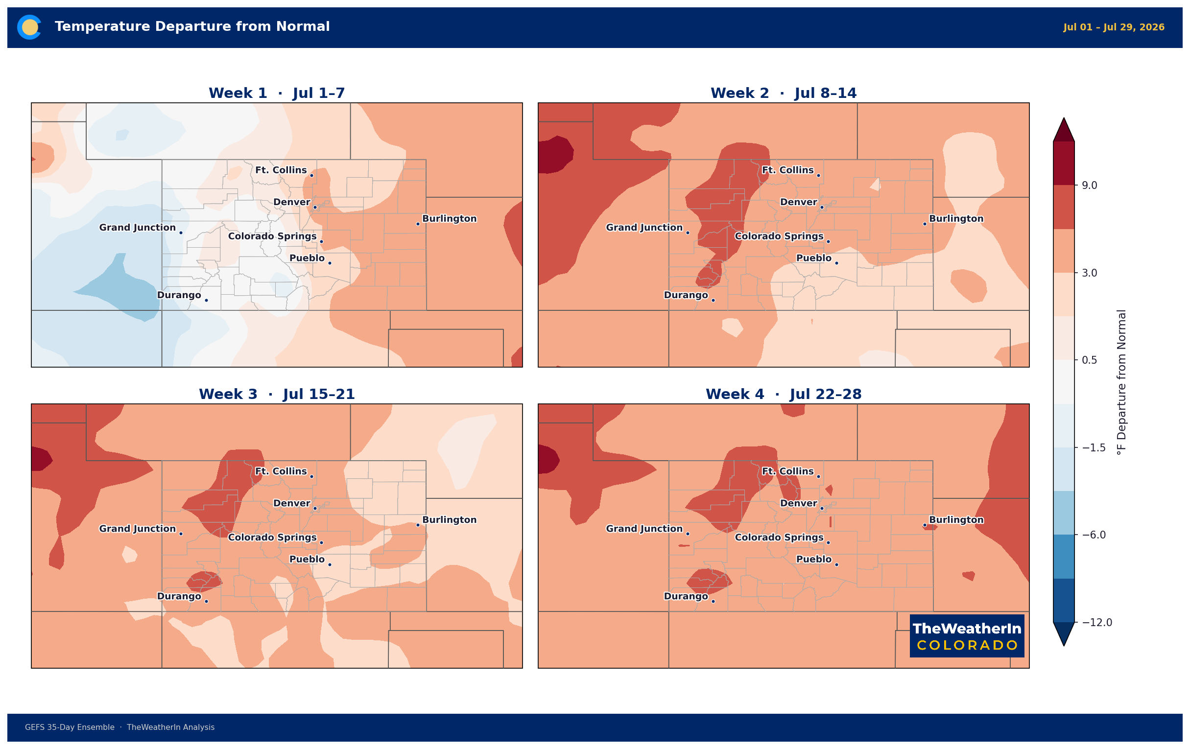
Four-week temperature anomaly outlook. Above-normal temperatures are expected to persist across most of Colorado through late July, though the pattern gradually moderates from current extremes.
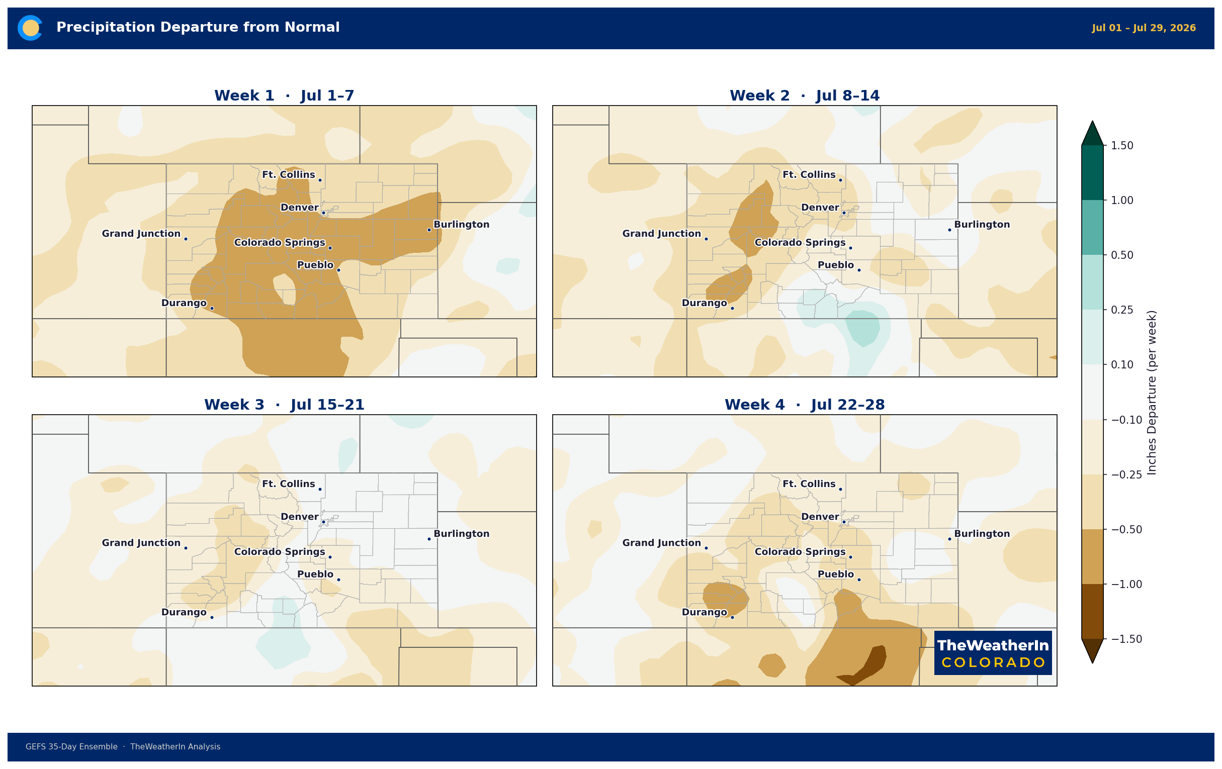
Four-week precipitation anomaly outlook. The best chance for near- or above-normal precipitation in the coming weeks lies across southern Colorado as southerly moisture flow increases.
Regional Breakdown: July 2–9
| Region | Temperature | Precipitation | Highlights |
|---|---|---|---|
| Front Range / Foothills | Near to slightly above normal Thu–Fri; near normal weekend | Below normal through Friday; isolated storms developing Saturday–Sunday | Severe storm risk today along Palmer Divide (hail, damaging wind, tornado); Red Flag Warnings in South Park Thu–Fri; storm chances increase next week |
| Mountains / High Country | Near normal | Below normal Thu–Fri; scattered afternoon/evening storms developing Sat–Sun | Critical fire weather Thu–Fri (SW winds 25–35 mph, RH below 15%); moisture gradually returns next week with slow-moving storm potential |
| Western Slope | Near normal Thu–Fri; +5°F above normal Sunday; triple digits in lower valleys mid-week | Dry through the period; wetting rain highly unlikely | Most critical fire weather region statewide Thu–Fri (Dolores, Montrose, San Miguel counties); single-digit RH; heat builds again mid-week |
| Eastern Plains | Low 90s Thu–Fri; near normal weekend; gradual warming next week | Severe storm risk today near Kansas border; isolated chances Friday evening; scattered storms near and after sunset Saturday; moisture increasing Sunday–Wednesday | Large hail (up to quarters), damaging wind gusts (60+ mph), tornado risk today for Baca, Bent, Kiowa counties; best wetting rain chances arrive mid-next week |
| Southern Colorado / San Luis Valley | 100–105°F Thu–Fri; hot and dry Saturday; gradual cooling with moisture return Sunday onward | Critically dry Thu–Sat; increasing afternoon/evening storm chances Sunday–Wednesday | Worst fire weather in the state Thu–Fri: single-digit RH, SW winds 25–35 mph, evening wind increases both days; poor overnight humidity recovery; slow-moving storms possible next week with flash flood risk on burn scars |
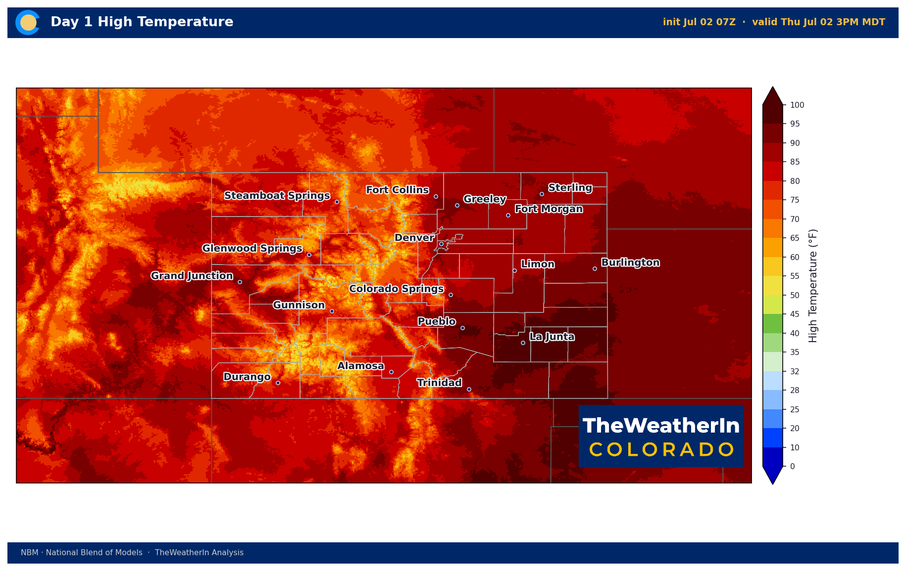
Forecast high temperatures for Thursday, July 2. Values of 100–105°F are expected across southeastern Colorado and the San Luis Valley.
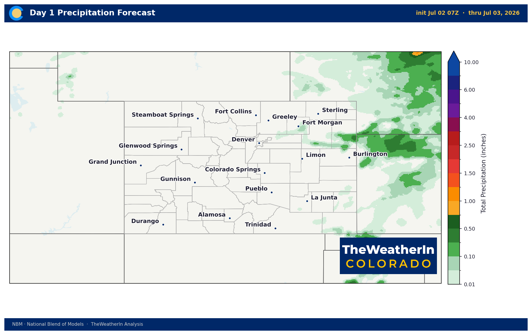
Forecast precipitation for Thursday, July 2. Isolated to scattered storm activity along the mountains and eastern plains; severe weather possible near the Kansas border.
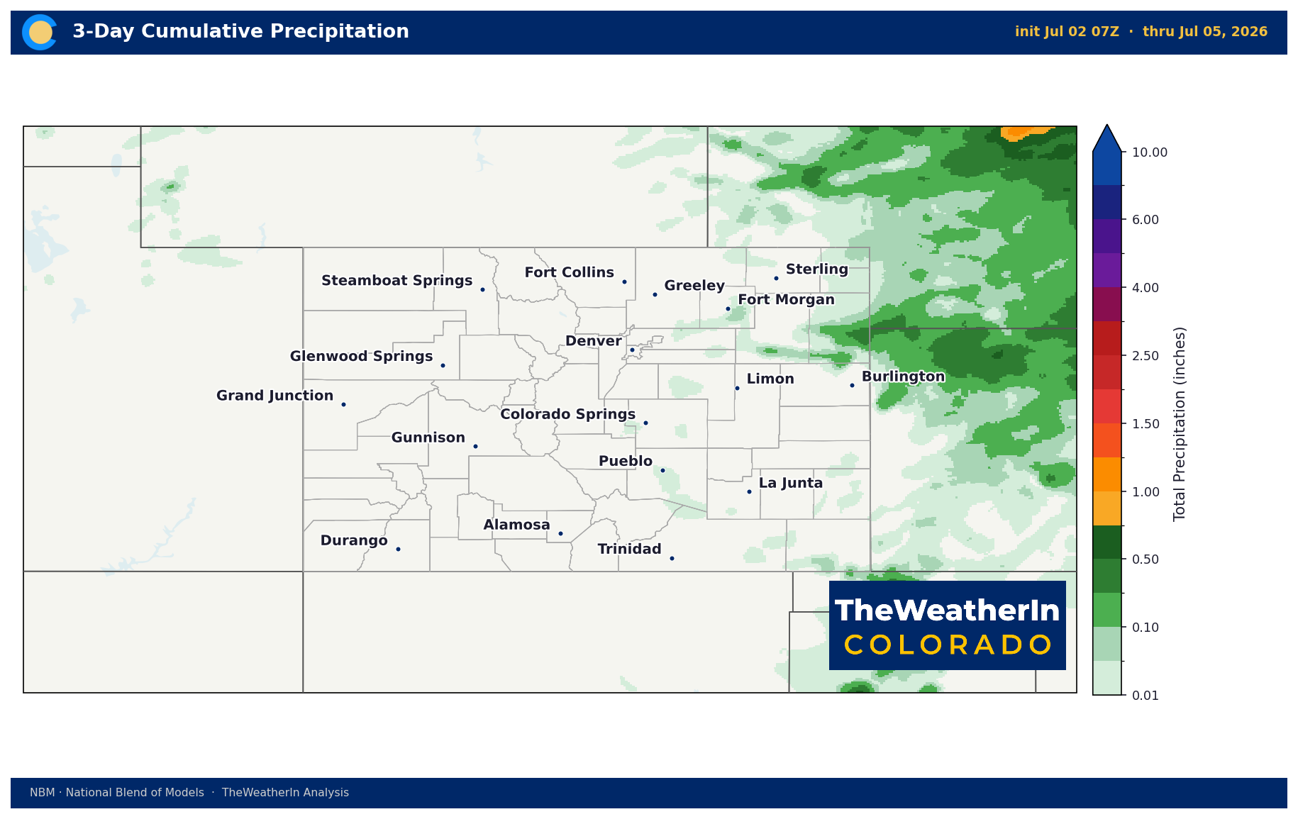
Forecast precipitation for Saturday, July 4. Isolated to scattered storms possible across east-central Colorado and the foothills — timing may impact fireworks displays near sunset.
Drought & Water
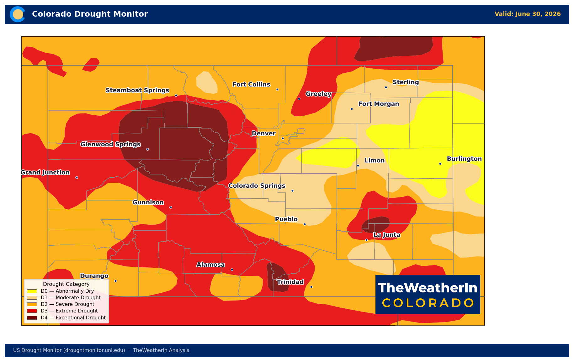
U.S. Drought Monitor for Colorado, June 23, 2026. Every part of the state remains in at least abnormal dryness; nearly 38% is in extreme to exceptional drought.
As of the June 23 Drought Monitor, 100% of Colorado remains in at least abnormal dryness (D0). Moderate drought or worse (D1–D4) covers 96.56% of the state. Extreme to exceptional drought (D3–D4) accounts for 37.94% of Colorado's land area — up from 34.62% the prior week. Exceptional drought (D4) alone covers 9.34%. The Drought Severity and Coverage Index — a composite measure that combines both the intensity and extent of drought across a state — stands at 329, more than double where it was a year ago (133) and more than double the start-of-year reading (127).
The week-over-week trend moved in the wrong direction: D3–D4 coverage expanded from 34.62% to 37.94%, and the DSCI jumped from 320 to 329. The near-term forecast offers no meaningful drought relief — the fire weather pattern through Friday is actively worsening soil moisture deficits, and even the gradual moisture return beginning Sunday will need to produce consistent, significant rainfall to register on the drought map. Isolated thunderstorm rainfall, even where it does fall, rarely produces the sustained totals needed to move drought categories.
The water supply picture behind the drought numbers is the more consequential story for the summer. Statewide May–July runoff is forecast at just 24% of the historical median. Roughly half of all Colorado streamflow measurement points are tracking toward record or near-record low flows for their entire periods of record — some dating back more than a century. Reservoir storage statewide sits at 85% of median as of May 1, but that figure is drawing down rapidly on carryover from 2025 with no mountain runoff to replenish it. The Arkansas basin is the most stressed, at 56% of median. This water supply deficit runs through the entire 2026 growing and recreation season — and it cannot be reversed by summer convection alone.
Agricultural Implications
- Fire prevention protocols in effect statewide through Friday. The combination of single-digit relative humidity, wind gusts to 40 mph, and temperatures near or above 100°F creates the conditions for rapid fire spread across the Eastern Plains, San Luis Valley, southern Colorado, and the Western Slope. Critically dry fuels on native grasslands and brush — cured well ahead of their normal schedule — mean any ignition has the potential to become a significant event quickly. No agricultural burning under any circumstances.
- Heat stress and irrigation demand spike this week. Temperatures of 100–105°F across the plains and valleys push evapotranspiration rates to their seasonal peak. Irrigation demand will be at or near maximum for this time of year. With statewide streamflow at a fraction of normal and water allocations already constrained, operators and irrigators should plan for the full demand hit Thursday through the weekend — and note that the gradual moisture return next week does not guarantee meaningful rainfall relief for eastern Colorado.
- Moisture return next week offers the first realistic wetting-rain window — but confidence is low. The southerly flow beginning Sunday could support slow-moving convection with locally heavy totals, particularly across southern Colorado and the foothills. Burn scar flash flood risk is a secondary concern if stronger cells develop. For dryland producers, the pattern shift is directionally positive, but the timing and coverage of any significant rainfall remain highly uncertain. The longer-range signal — a potentially strong El Niño winter — offers the most credible drought relief pathway, but that's a November story, not a July one.
The signal worth watching through the rest of July: whether the gradual moisture increase from the south develops into a true monsoon pattern across southern Colorado and the San Juans — or stalls short, as it has in several recent summers — will determine whether the fire weather threat shifts from statewide to regional before the end of the month.



