
Colorado Drought Update: Week of June 2, 2026
A modest improvement in the most severe drought categories this week — but 99% of Colorado remains in drought, and the four-week outlook delivers no path to recovery.

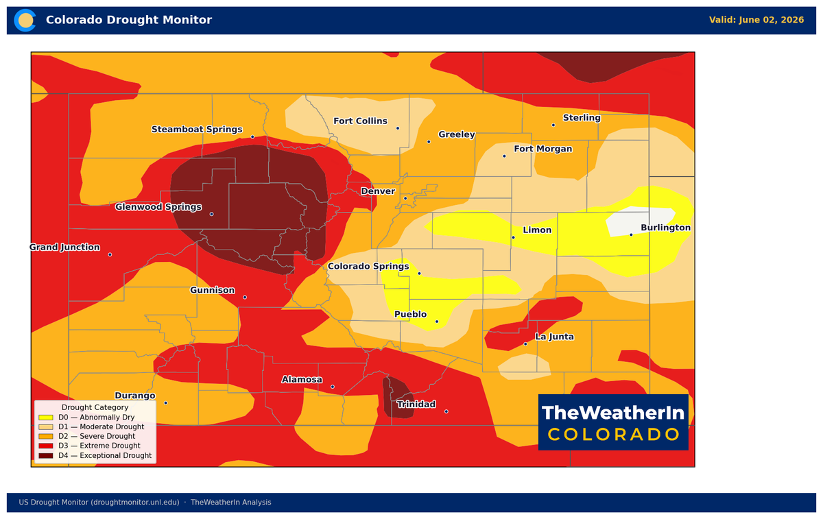
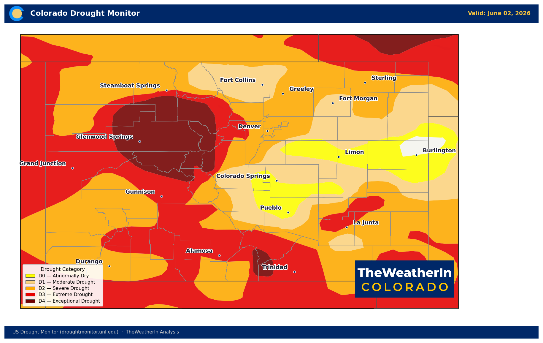
The June 2 U.S. Drought Monitor shows the first measurable improvement in Colorado's drought footprint in weeks — a modest but real directional shift in the most severe categories. The broader picture, however, remains unchanged: nearly all of Colorado is still in drought, the current forecast offers no meaningful precipitation, and the water supply deficit running through the rest of 2026 is not going anywhere.
What the Latest Data Shows
The Drought Severity and Coverage Index — a composite measure of drought extent and intensity — improved from 321 last week to 313 this week. The most notable change was at the extreme end of the spectrum: the area in extreme drought (D3) or worse declined from 40.24% to 35.95%, and exceptional drought (D4) edged down from 9.51% to 8.82%. For the first time in weeks, a thin slice of the state — 0.55% — exited drought entirely.
| Category | This Week (Jun 2) | Last Week (May 26) | Change |
|---|---|---|---|
| No Drought | 0.55% | 0% | +0.55% |
| D0–D4 (Abnormal–Exceptional) | 99.45% | 100% | −0.55% |
| D1–D4 (Moderate–Exceptional) | 92.66% | 93.58% | −0.92% |
| D2–D4 (Severe–Exceptional) | 75.98% | 77.67% | −1.69% |
| D3–D4 (Extreme–Exceptional) | 35.95% | 40.24% | −4.29% |
| D4 (Exceptional) | 8.82% | 9.51% | −0.69% |
| DSCI (Drought Index) | 313 | 321 | −8 |
The improvement in D3 and D4 likely reflects moisture from late-May mountain precipitation and some limited soil recharge in isolated areas. The direction of movement is encouraging, but a 4-point reduction in D3+ coverage still leaves more than a third of Colorado in extreme drought. Three months ago, roughly 36% of Colorado was drought-free. Today, that figure is 0.55%.
Four-Week Outlook: No Meaningful Relief
The forecast data for the next four weeks shows no pattern shift that would deliver meaningful precipitation to drought-stressed areas across Colorado.
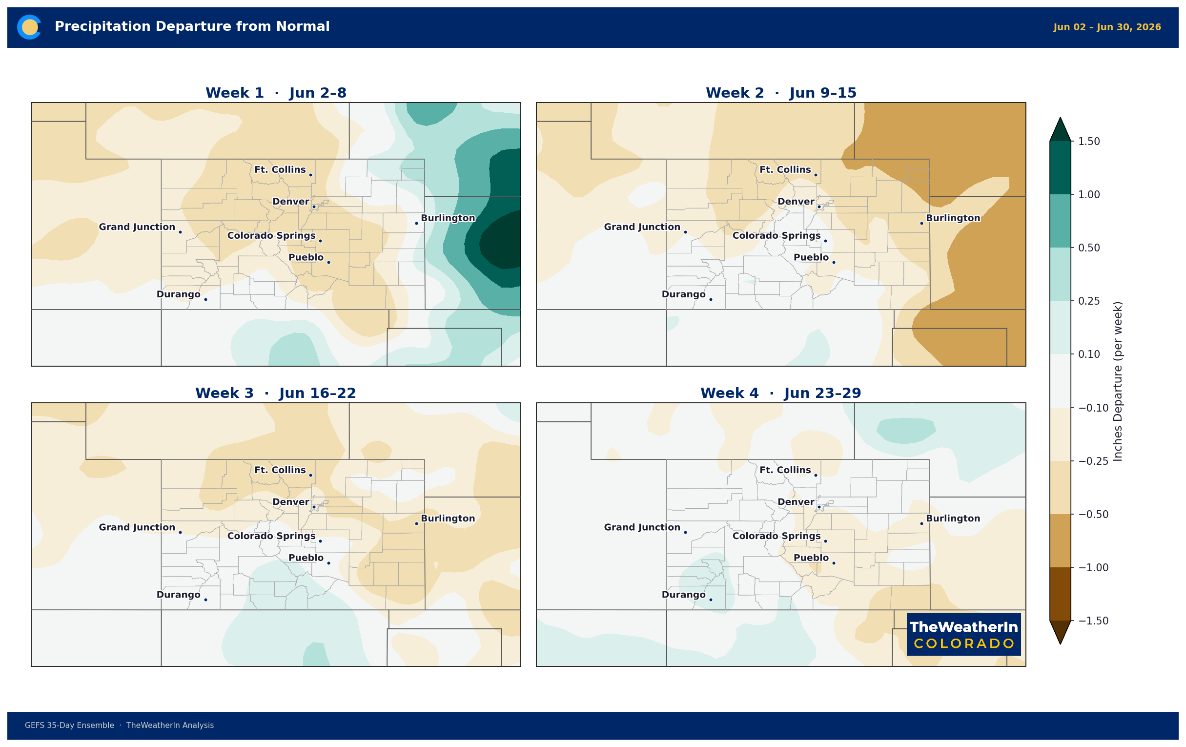
The first week of June is the sharpest signal: a strong ridge of high pressure is delivering near-record heat, critically low humidity, and active fire weather conditions statewide, with essentially zero precipitation in the forecast. Weeks 2 and 3 (June 10–23) maintain a warm, below-normal precipitation tilt across most of the state — there are signals of some relaxation in the ridge, which could allow for isolated afternoon convective activity, but nothing resembling a drought-busting precipitation event. Week 4 (June 24–30) continues the same pattern.
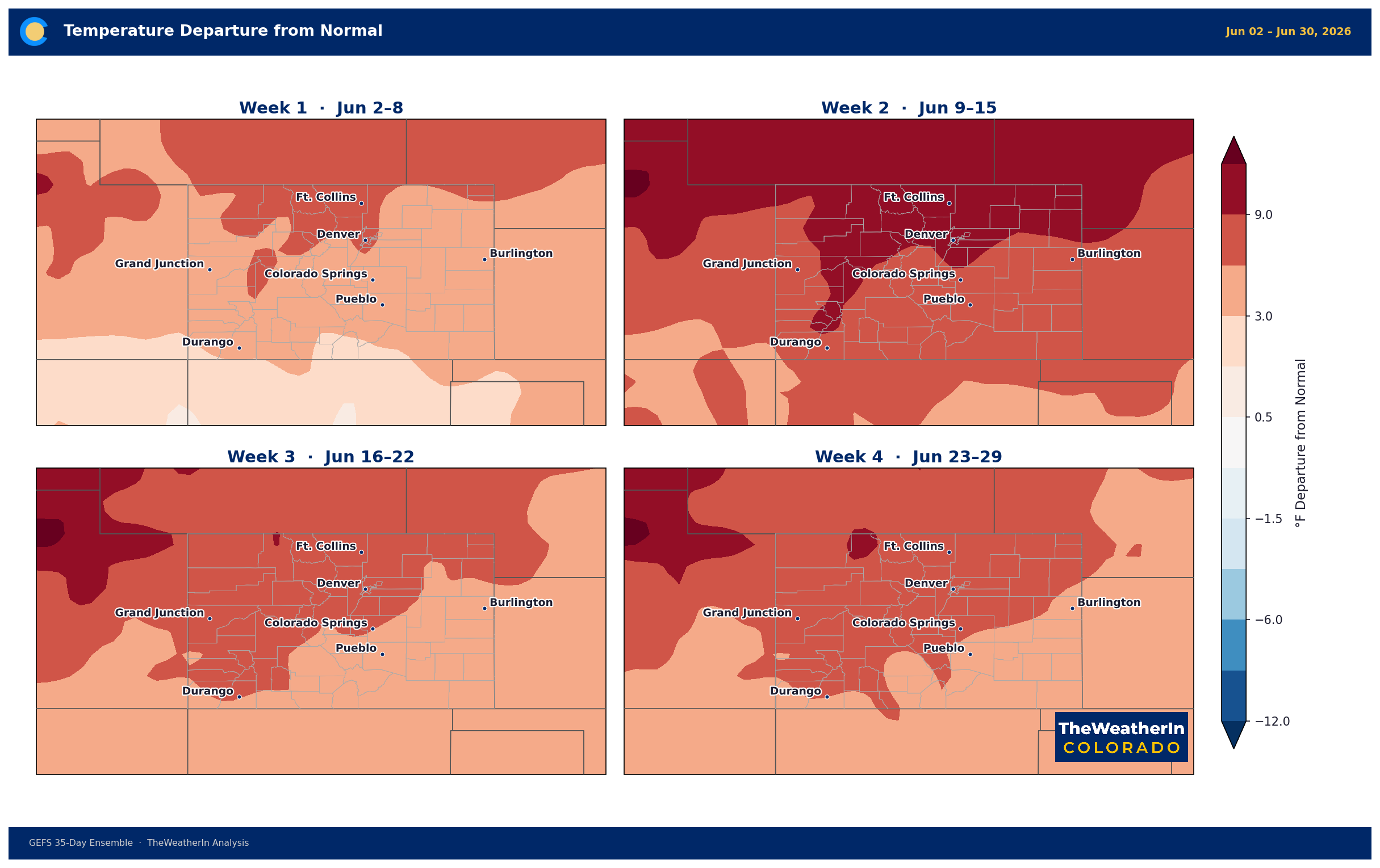
What this means for drought: the DSCI is likely to trend flat to slightly higher (worsening) over the coming weeks as heat and dry conditions accelerate evaporative demand. Any isolated mountain storms provide local moisture but do not move statewide metrics. Every week of hot, dry, windy conditions adds to a soil moisture deficit that already extends to the base of most soil profiles.
Agricultural and Water Supply Implications
This weekend's forecast for near-record heat (low-to-mid 90s on the plains, triple digits possible in lower Western Slope valleys) arrives on top of soils already running well below normal moisture. Evapotranspiration demand will spike to seasonal highs Saturday and Sunday, straining irrigated fields and hammering dryland producers who entered June with no meaningful moisture carry-in from winter. Statewide May–July streamflow forecasts remain at just 24% of normal — water allocations are under pressure across nearly every Colorado basin.
The fire weather risk this weekend is the acute, visible expression of the drought — near-zero humidity, gusty southwest winds, and critically dry fuels on rangelands from the Eastern Plains to the Western Slope. The same conditions that make this weekend dangerous for ignition are the same conditions making drought recovery impossible.
What to Watch
Two developments could eventually shift the drought trajectory — but both operate on a months-long timeline.
Colorado's summer monsoon, which historically begins to influence southern portions of the state in July, is the most realistic near-term pathway for some drought improvement. A significant monsoon season can provide meaningful soil recharge in the San Juan Mountains and southernmost counties. But it delivers moisture in a narrow window, and the deficit is deep enough that even a good monsoon only partially offsets months of extreme drying.
The longer-range factor is El Niño, which is now forming in the tropical Pacific and expected to be moderate to strong. That pattern historically delivers above-normal precipitation to the southern Rockies — but those impacts are a winter story at the earliest. The 2026 water supply gap, measured in reservoir drawdowns and near-record-low river flows, is already locked in for this growing and recreation season regardless of how summer precipitation develops.
The signal worth watching heading into late June: whether any monsoon moisture begins tracking northward ahead of its typical arrival window — and whether this weekend's fire activity remains manageable given the exceptional conditions in the forecast.



