Colorado Spring and Summer Outlook — April 2026
A persistently warm spring and summer is favored across Colorado, with a mixed and regionally split precipitation signal through the season.
Based on the April 2026 multi-model ensemble seasonal forecast.
The Big Picture
The dominant signal through spring and into summer is warmth — above-normal temperatures are favored statewide from April through at least July, with the eastern plains and Front Range carrying the strongest signal. Precipitation is
more nuanced: the western mountains trend wetter as the season progresses, while the eastern plains carry a drier lean through April and May.
Temperature: May through October
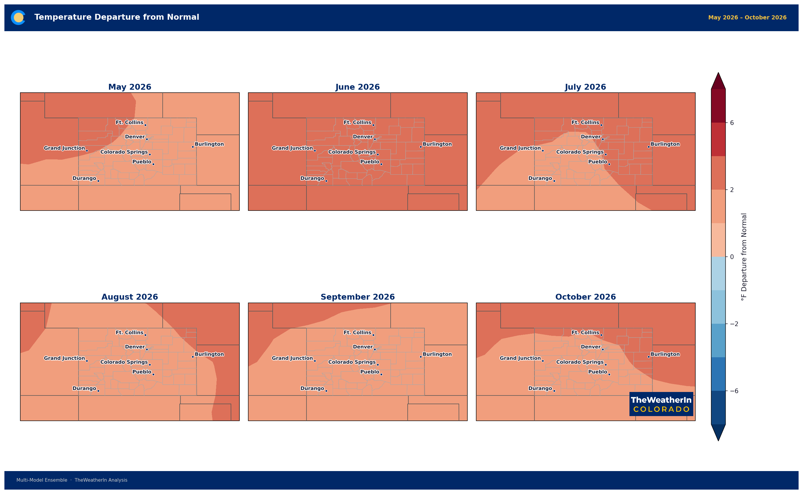
The temperature signal is remarkably consistent across the full outlook period. May and June show the strongest anomalies — departures of +4 to +6°F are favored across eastern and central Colorado, with the Front Range corridor
running particularly warm. The signal modulates into late summer and fall but stays above normal through October for most of the state.
The western slope and mountain areas trend toward near-normal in August and September before a more mixed signal emerges in October.
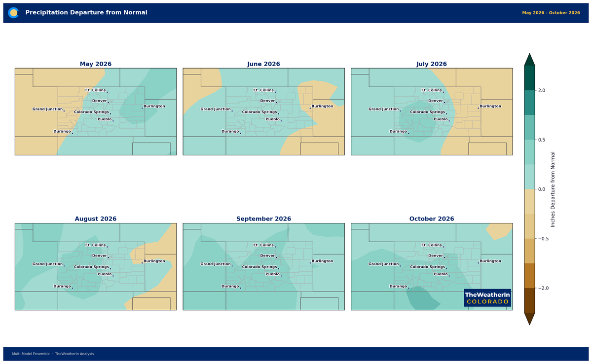
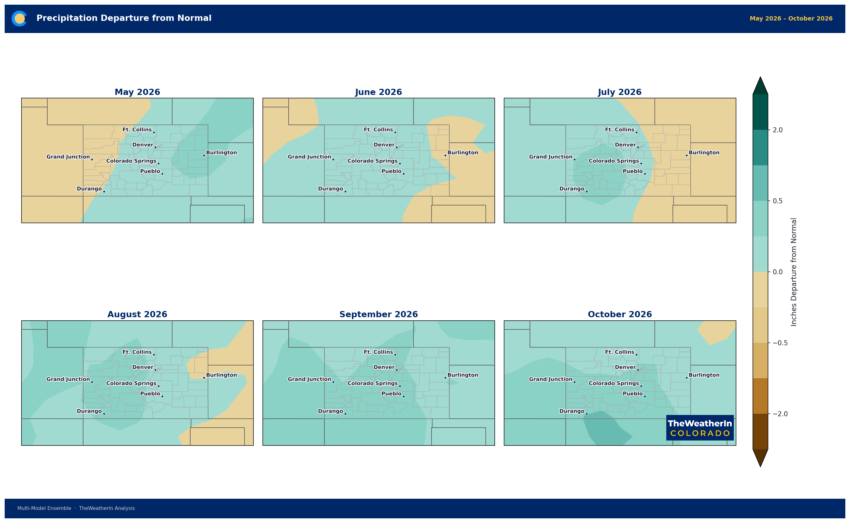
Precipitation: Spring into Summer
Rather than anomaly maps, the precipitation outlook is best understood through model agreement — the maps below show the percentage of models favoring above-normal minus those favoring below-normal precipitation. Teal indicates a
wetter lean; brown indicates a drier lean.
April–June
The spring precipitation signal splits the state. The northwestern mountains and western slope show a wet lean — 20 to 40% more models favoring above-normal precipitation. The eastern plains trend drier, particularly the southeast corner. The Front Range sits in a near-neutral zone. For dryland agriculture on the plains, this is the most concerning part of the outlook.
May–July
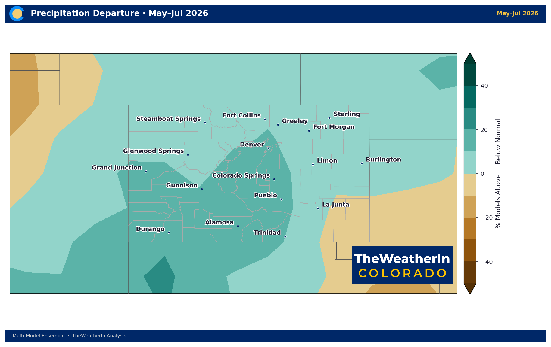
The precipitation signal improves significantly by the May–July window. Central Colorado, the mountains, and the Front Range all shift toward a wet lean — 20 to 40% net model agreement for above-normal moisture. This is an encouraging signal for wildfire season heading into the summer months. The eastern plains remain mixed.
June–August
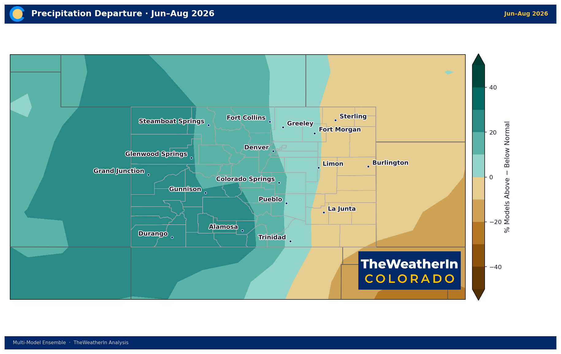
The wet signal broadens and strengthens across the mountains and western slope through June–August — this likely reflects an active early monsoon signal. The eastern plains trend toward near-neutral, with the far southeast corner
remaining the driest part of the state.
What This Means by Sector
Agriculture: A warm, dry April–May raises early-season drought concerns for dryland operations on the eastern plains. Planting decisions should account for potentially limited early moisture. The outlook improves for summer —
above-normal mountain moisture is a positive for irrigation water supplies.
Snowpack: Rapid melt is likely with persistent above-normal temperatures through May and June. Runoff timing will likely be early, with peak flows arriving 2–3 weeks ahead of average in most basins.
Wildfire: The warm, dry spring signal on the eastern plains and southern Colorado elevates fire weather risk through May. The improving moisture outlook for June–July in the mountains is encouraging, but the critical window is April–May.
Recreation: A warm spring means early access to trails and high-country roads, but snowpack-dependent activities (skiing, late-season backcountry) will wrap up earlier than normal. Summer recreation conditions look favorable with
above-normal moisture in the mountains.
Bottom Line
Warmth is the most consistent signal in this outlook — expect a spring and summer that runs above normal statewide. Precipitation is the wildcard, with a clear east-west split: the mountains and western slope trend wetter as the
season progresses while the eastern plains face a drier lean through spring. The monsoon signal for June–August looks encouraging.
Forecast based on the multi-model ensemble. Seasonal forecasts carry significant uncertainty beyond 30 days — use as a general guide, not a precise prediction.