
Fire Weather, Flash Floods, and a Drought That Isn't Done
An active storm pattern brings flash flood and severe weather threats this week — but the bigger story is what follows: a dry, fire-prone summer and a water crisis still deepening.

Colorado gets a week of active weather — storms, flash flood watches, severe thunderstorm potential, and a fire weather watch all in the same seven days — but don't let the rain fool you. The drought that has gripped every corner of this state since winter isn't going anywhere just yet, and the pattern shaping up for early summer keeps that story running.
Pattern Overview
A series of weak disturbances rotating around a blocking ridge to the west is driving an unusually unsettled late-May pattern across Colorado. That setup keeps frequent afternoon and evening thunderstorms firing across the mountains and high country through the week, with scattered activity reaching the plains on the more active days. It's an active pattern by the calendar, but one with sharp geographic contrasts — the same week that brings locally heavy mountain rain also produces critical fire weather on the Western Slope and in the San Luis Valley as drier, warmer air surges back in behind each storm.
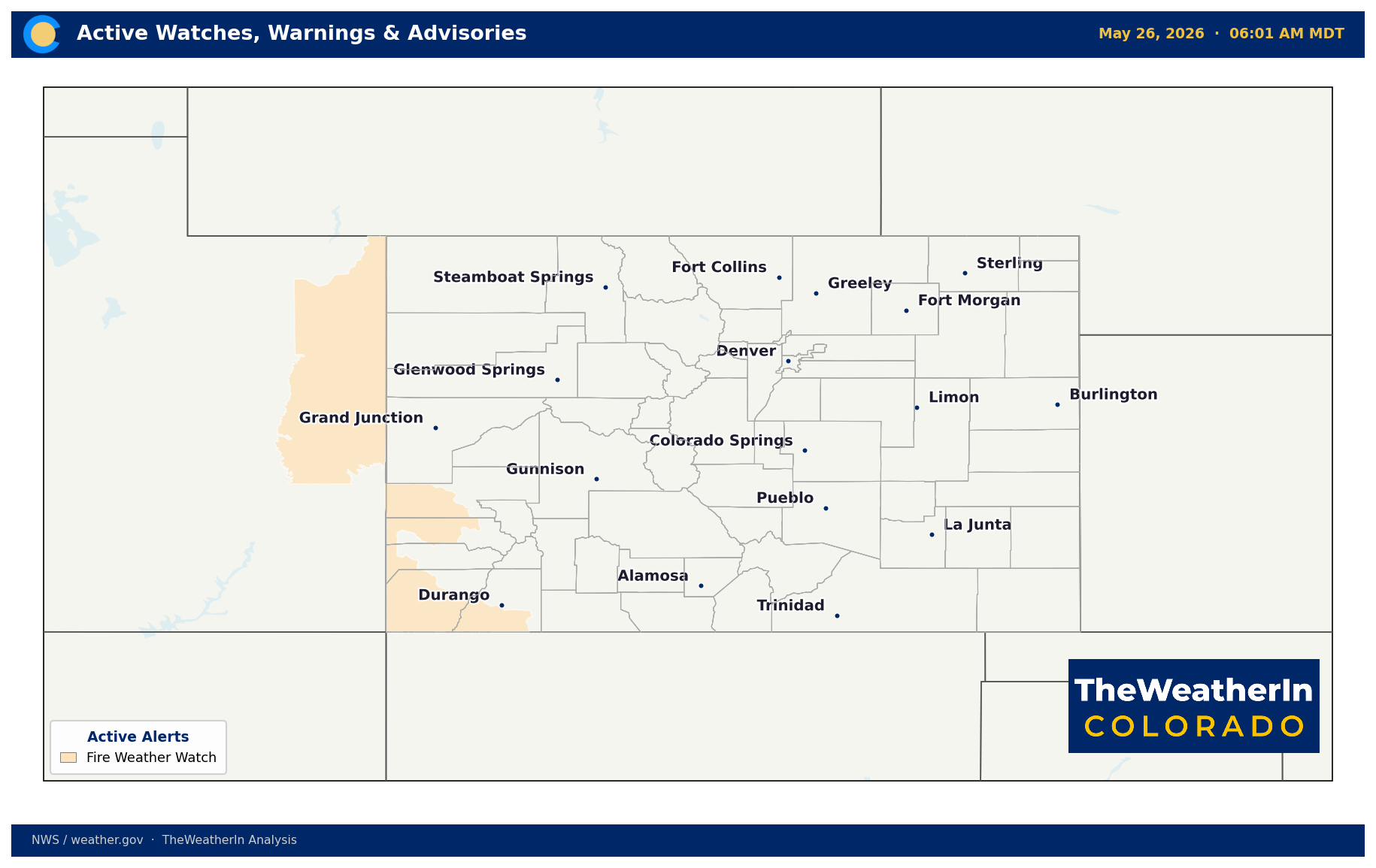
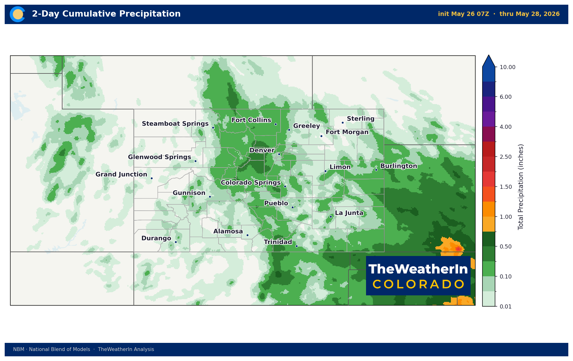
Wednesday is the focal point for multiple hazards simultaneously. A Denver cyclone may develop along the I-25 corridor by afternoon, fueling widespread storms capable of producing locally heavy rain — including over the East Troublesome burn scar and Four Corners region, where the ground is primed for flash flooding. At the same time, a Fire Weather Watch goes into effect Wednesday afternoon for fire zones in western Colorado and eastern Utah, where strong southwesterly winds will gust 30–40 mph and relative humidity drops below 15 percent. The wet and the dangerous dry exist side by side, separated by a few hundred miles and a ridgeline.
The larger driver here is the same blocking pattern that has kept Colorado warm and dry for most of the past six months — La Niña's legacy in the atmospheric circulation. That influence is weakening. NOAA issued an El Niño Watch on May 14, and the subsurface of the tropical Pacific has been warming for six consecutive months. El Niño is expected to emerge this summer with high confidence and persist through next winter. Historically, that shift brings above-normal precipitation to the southern Rockies — but it hasn't arrived yet, strength remains uncertain, and no single season's climate flip erases a drought built over the past year and a half.
Weeks Ahead: 2–4 Week Outlook
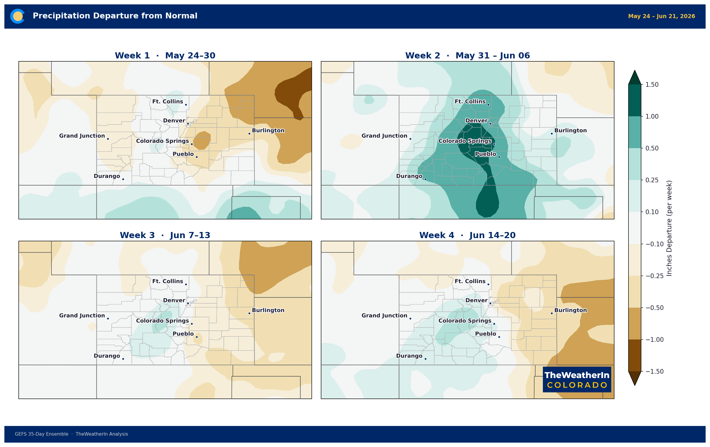
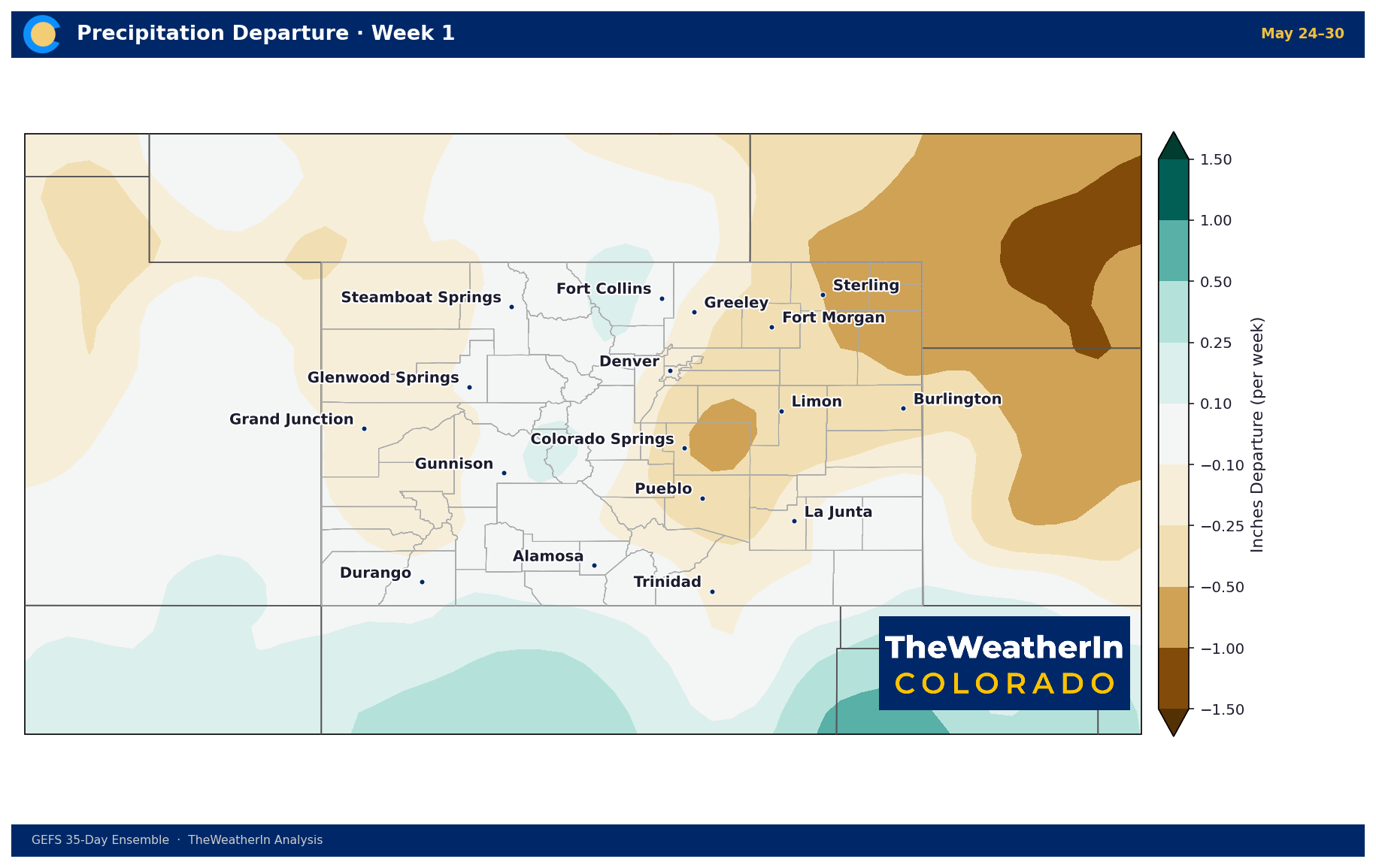
The active pattern holds through early June before a transition becomes more likely. Forecast data through weeks two and three suggest a gradual return toward drier and warmer conditions across much of the state, with the most pronounced signal — above-normal temperatures and below-normal precipitation — tilted toward the southern half of Colorado. The Four Corners region and San Luis Valley face the most persistent fire weather risk as fuels remain critically dry and the wet period this week is unlikely to provide more than a brief reprieve at lower elevations.
By week four, uncertainty increases, but the overall pattern lean is for continued warmth statewide. There is a low-confidence signal for a wetter pattern to nudge back in from the west, consistent with the slow-building El Niño influence — but "wetter than the recent trend" still means well below what's needed to meaningfully address a drought of this scale. The rivers are already running out, and that reality doesn't change with a few storm weeks.

Regional Breakdown — Week of May 26
| Region | Temperature | Precipitation | Highlights |
|---|---|---|---|
| Front Range / Foothills | Near normal (upper 70s–low 80s) | Best chance of the week | Wednesday most active — widespread storms, possible Denver cyclone, locally heavy rain; severe storm potential Friday–Saturday |
| Mountains / High Country | Near normal (upper 50s–70s by elevation) | Best rainfall of the week statewide | Daily afternoon storms Tuesday–Friday; flash flood concern over East Troublesome burn scar; orographic enhancement on higher terrain |
| Western Slope | +10–15°F above normal Wed–Fri | Well below normal Wed–weekend | Fire Weather Watch in effect Wednesday; RH below 15%, SW winds 30–40 mph gusts; flash flood risk from burn scars Tuesday–Wednesday before dry-down |
| Eastern Plains | Near normal (upper 70s–low 80s) | Mainly dry until Friday | Elevated fire weather Tuesday (gusty SSE winds, little rain reaching plains); severe storm threat builds Friday evening into Saturday — wind and hail primary concerns |
| Southern CO / San Luis Valley | +10–15°F above normal in valleys Thu–Fri | Interior valleys very dry Wed–Fri | Split pattern: eastern mountains and plains see storms, San Luis Valley dries out rapidly Wednesday; elevated fire danger Thursday–Friday; slight easing possible weekend |
Drought & Water
As of the May 12 Drought Monitor, 100 percent of Colorado remains in drought — every square mile of the state, without exception. Roughly 96 percent is at moderate drought (D1) or worse, and 47 percent is in extreme or exceptional drought (D3–D4). That last figure is down from 58 percent the prior week, a meaningful week-over-week improvement in the worst categories, driven largely by late-spring storms. But the overall drought footprint is unchanged, and the trajectory of the broader water supply picture is not improving.
Statewide snowpack peaked in mid-March at roughly half of a normal year's accumulation — and then nearly all of it melted in one of the warmest Marches ever recorded. By May 1, snowpack statewide stood at 20 percent of the long-term median, the lowest on record for that date. The April 1 snow water equivalent statewide was just 1.66 inches — less than one-third of the previous all-time record low, set in 1976–77. That collapse is now translating directly into streamflow. The statewide May–July runoff forecast is just 24 percent of a normal year. Nearly half of all Colorado streamflow forecast points are on track for record or near-record low flows. The Colorado River near the Utah border is forecast at 23 percent of a normal year — a shortfall of approximately 2.5 million acre-feet.
The rain this week is genuinely welcome. Slow-moving storms Wednesday could deliver meaningful totals to some mountain areas and foothills, and any wetting rain on critically dry soils helps. But it cannot close the gap left by a snowpack that was never there. Reservoir storage statewide sits at 85 percent of median on stored carryover — but with incoming runoff at historic lows, that carryover is the only buffer. Once it's drawn down through summer, there is no replenishment pipeline behind it.
Agricultural Implications
- Soil moisture and forage: Tuesday–Wednesday rain provides short-term relief to critically dry soils across the mountains and foothills, and is beneficial for spring forage development. The northern Front Range and southeastern Plains were near record-dry in April — any meaningful precipitation this week helps, but underlying soil moisture deficits are deep and won't reverse with one wet period.
- Fire weather and grazing land: Wednesday through Friday brings the most significant fire weather risk of the week across the Western Slope and San Luis Valley. Grass and brush cured well ahead of normal; the aggressive dry-down behind each storm system means fire potential rebounds quickly after any rainfall. Producers with grazing operations in fire-prone areas should monitor conditions closely Wednesday afternoon through Thursday.
- Wind stress and newly planted crops: Strong southwesterly winds Wednesday through Friday across the Western Slope and valley floors could stress newly planted rows and soil crusting. Weekend conditions ease considerably. Irrigation water availability remains severely limited statewide heading into the growing season — streamflow forecasts across the Arkansas, South Platte, and Colorado basins are running 20–37 percent of normal for May through July.
The most important signal to watch heading into summer is whether the El Niño now forming in the tropical Pacific develops enough strength to shift the late-summer and fall precipitation pattern — that question won't have a clear answer until later this ummer, but it is the water supply story that matters most for Colorado producers beyond this season.



