Forecast Validated: Colorado's Fire Season Arrived Early — and the Pattern Isn't Done
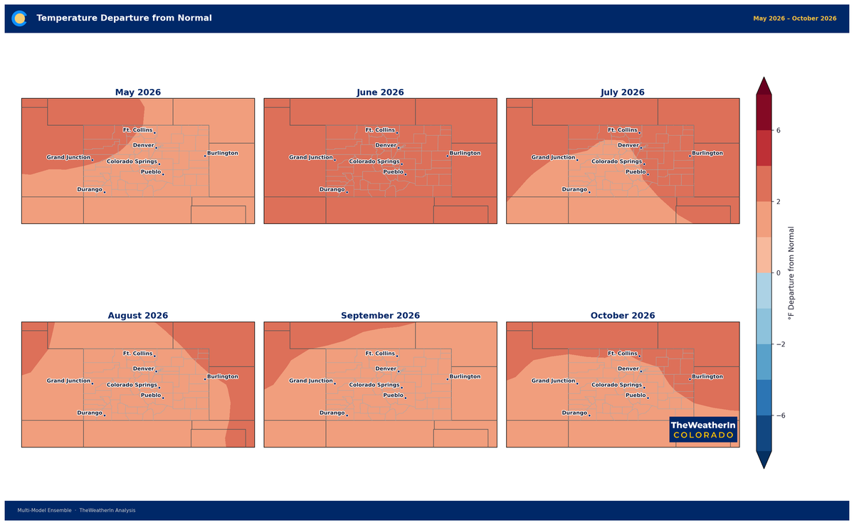
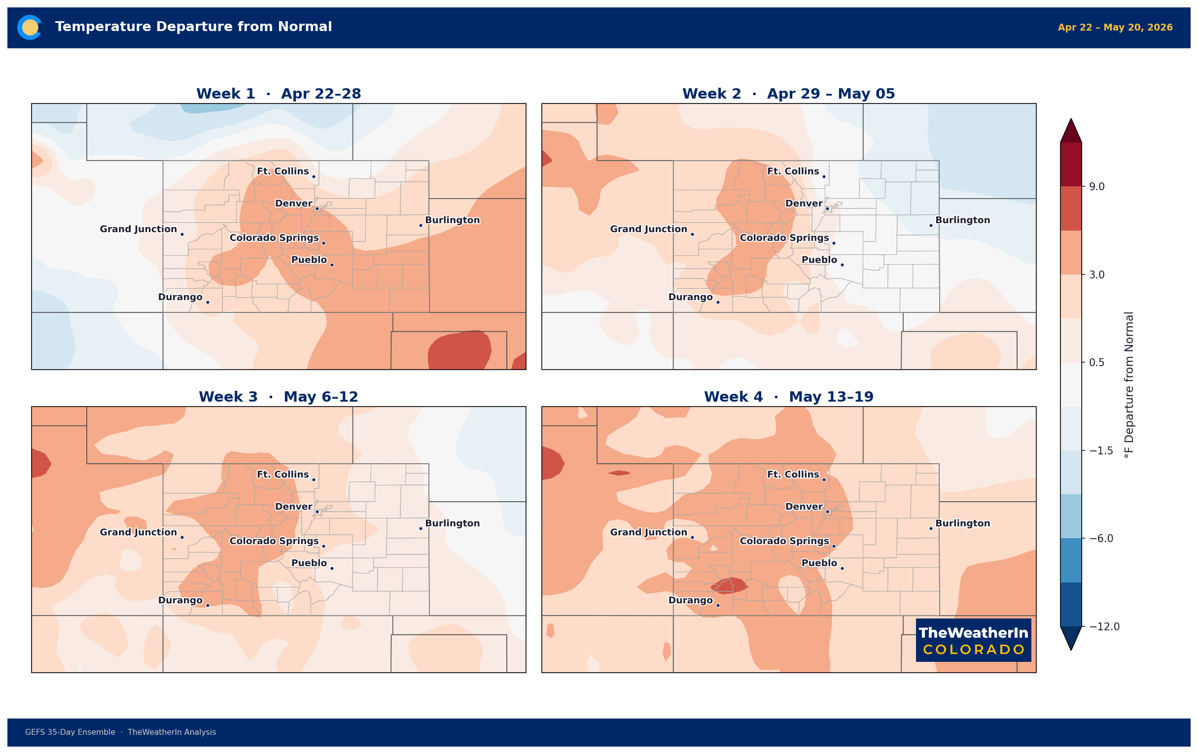
Following the weekend system, forecast data indicates a return to above-normal temperatures and below-normal precipitation across most of Colorado through late April and into May.
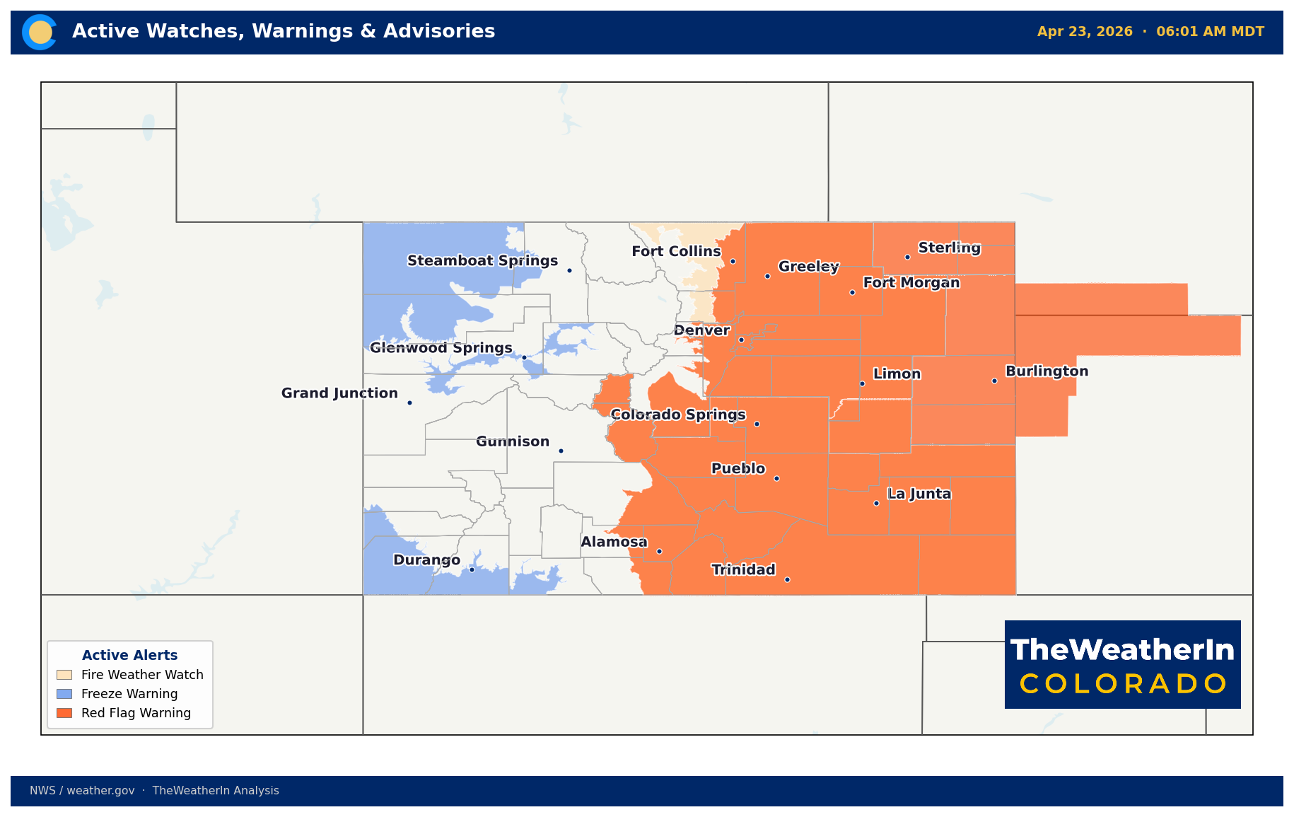
Ten days ago, we published a spring and summer outlook warning that Colorado's fire season would arrive early, drought would deepen, and above-normal heat would persist well into summer. On April 22, a Particularly Dangerous Situation Red Flag Warning — one of the most rarely issued fire weather designations — was active across the Front Range foothills, with wind gusts of 45 to 55 mph and relative humidity values in the single digits. The forecast is playing out on schedule.
A brief break arrives this weekend. It changes the near-term numbers, but not the larger story.
What Is Driving This Pattern
Parts of Colorado have been running roughly 20 degrees above normal this week — not because of a single storm system, but because of a persistent ridge of high pressure anchored over the Intermountain West. Ridges like this suppress cloud cover and storm development, allow the ground to dry out rapidly, and push downslope (drying) winds along the Front Range. The fire behavior observed on April 22 — rapid spread, extreme spotting potential, dangerous burn conditions — is the direct result of that setup.
The deeper driver is a shift in large-scale ocean temperatures. La Niña, which had been suppressing storm tracks across the southern tier of the country since late 2024, officially ended this spring. We are now transitioning toward a neutral state, and forecast data suggests an El Niño pattern is very likely to develop during summer and fall 2026. For Colorado, that transition historically favors warmer and drier-than-normal conditions through at least early summer, before the El Niño signal has fully established itself.
In practical terms: the same pattern that produced the exceptional warmth and fire weather of early and mid-April is expected to remain the dominant theme through May and likely into June, with only temporary interruptions. This weekend's system is one of those interruptions — not a trend change.
This Weekend — A Pause, Not a Reset
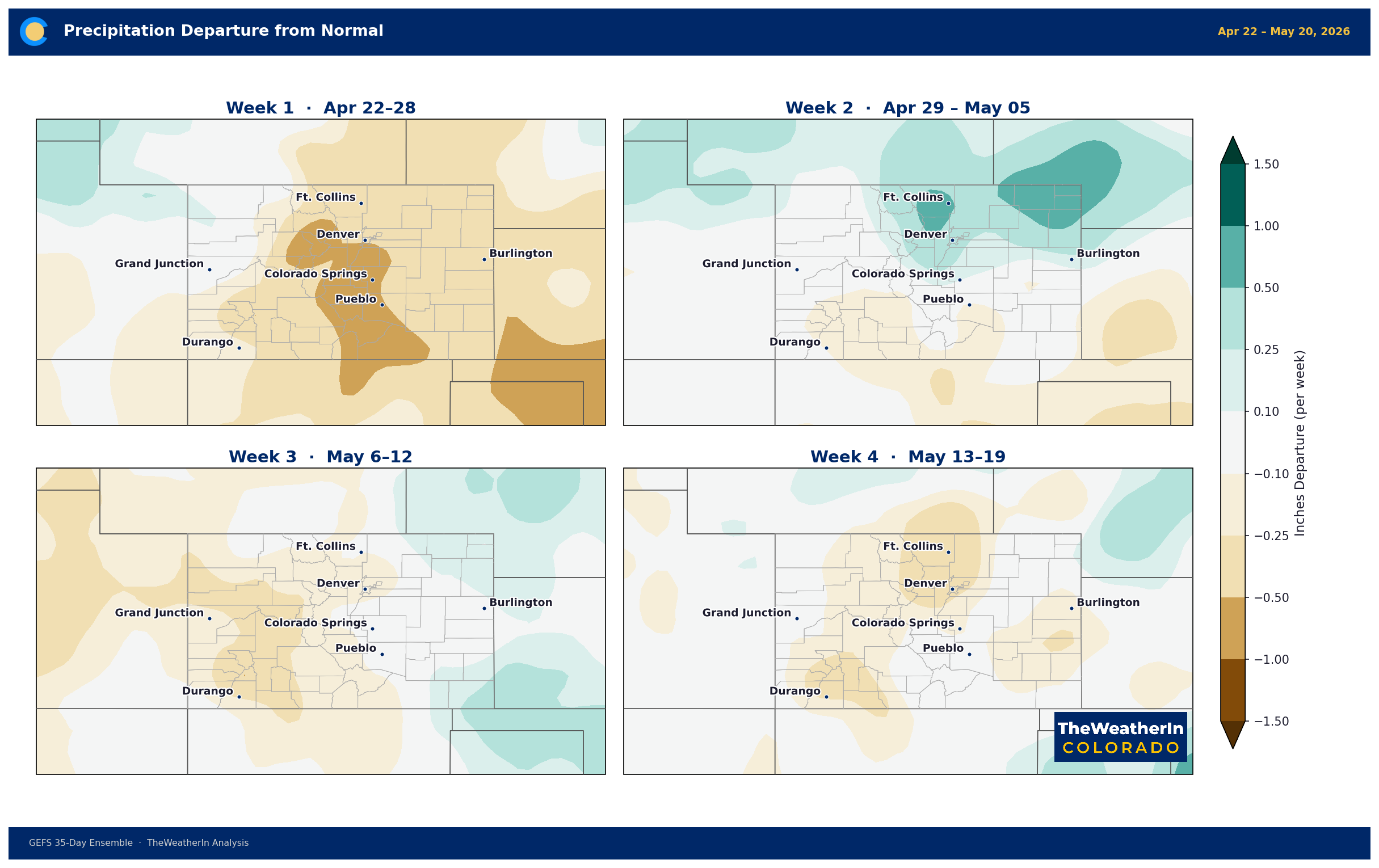
A system will push into the region late Saturday into Sunday, bringing cloud cover, a modest wind shift, and some precipitation. The Continental Divide and the higher terrain of central Colorado are expected to see 0.25 to 0.50 inches of liquid, which will translate to late-season snow above 9,000 feet or so. Temperatures will drop back to near-normal levels for a few days.
This is meaningful for fire management — a brief window of reduced fire weather threat — but it is not enough moisture to meaningfully improve drought or snowpack. After the system passes, the pattern rebuilds. Above-normal temperatures are expected to return by mid-May, and the fire weather threat will re-emerge with vegetation cured and soils dry.
Weeks Ahead — Late April Through May
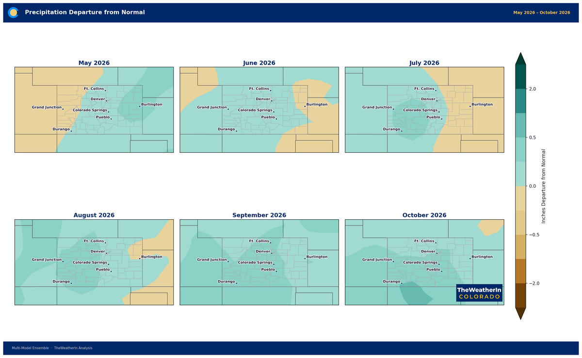
Following the weekend system, forecast data indicates a return to above-normal temperatures and below-normal precipitation across most of Colorado through late April and into May. The Front Range and Eastern Plains are most likely to see the warmest departures, with the mountains running above normal as well. Precipitation chances will remain limited outside of isolated afternoon thunderstorm activity — which tends to be inefficient for drought relief at this time of year, with high evaporation rates and shallow soil moisture uptake.
June brings slightly more uncertainty. The monsoon pattern — which typically begins delivering moisture to southern and southeastern Colorado in mid-to-late July — will be a critical signal to watch. An early monsoon onset would be the most significant wildcard capable of interrupting the warm, dry summer pattern. As of now, there is no signal suggesting an early start; the outlook favors a near-normal to slightly late monsoon onset.
The months most at risk for prolonged heat and fire weather: May, June, and early July. Plan accordingly. The 6-month outlook maps are available to Insiders here.
Colorado 4-Week Outlook by Region
| Region | Temperature Outlook | Precipitation Outlook | Key Concerns |
|---|---|---|---|
| Front Range & Foothills | Above normal | Below normal | Active fire weather threat; drought deepening; early heat stress |
| Eastern Plains | Above normal | Below to near normal | Dry spring stress on dryland crops and pasture; wind erosion risk |
| Mountains & Continental Divide | Above normal | Below normal | Dismal snowpack; peak runoff weeks early; late-season snow limited |
| Western Slope | Above normal | Below normal | Drought worsening; Colorado River tributary inflows declining ahead of schedule |
| San Luis Valley & Southern Colorado | Above normal | Below to near normal | D3–D4 drought entrenched; fire risk elevated |
Drought & Water Supply
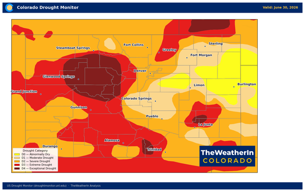
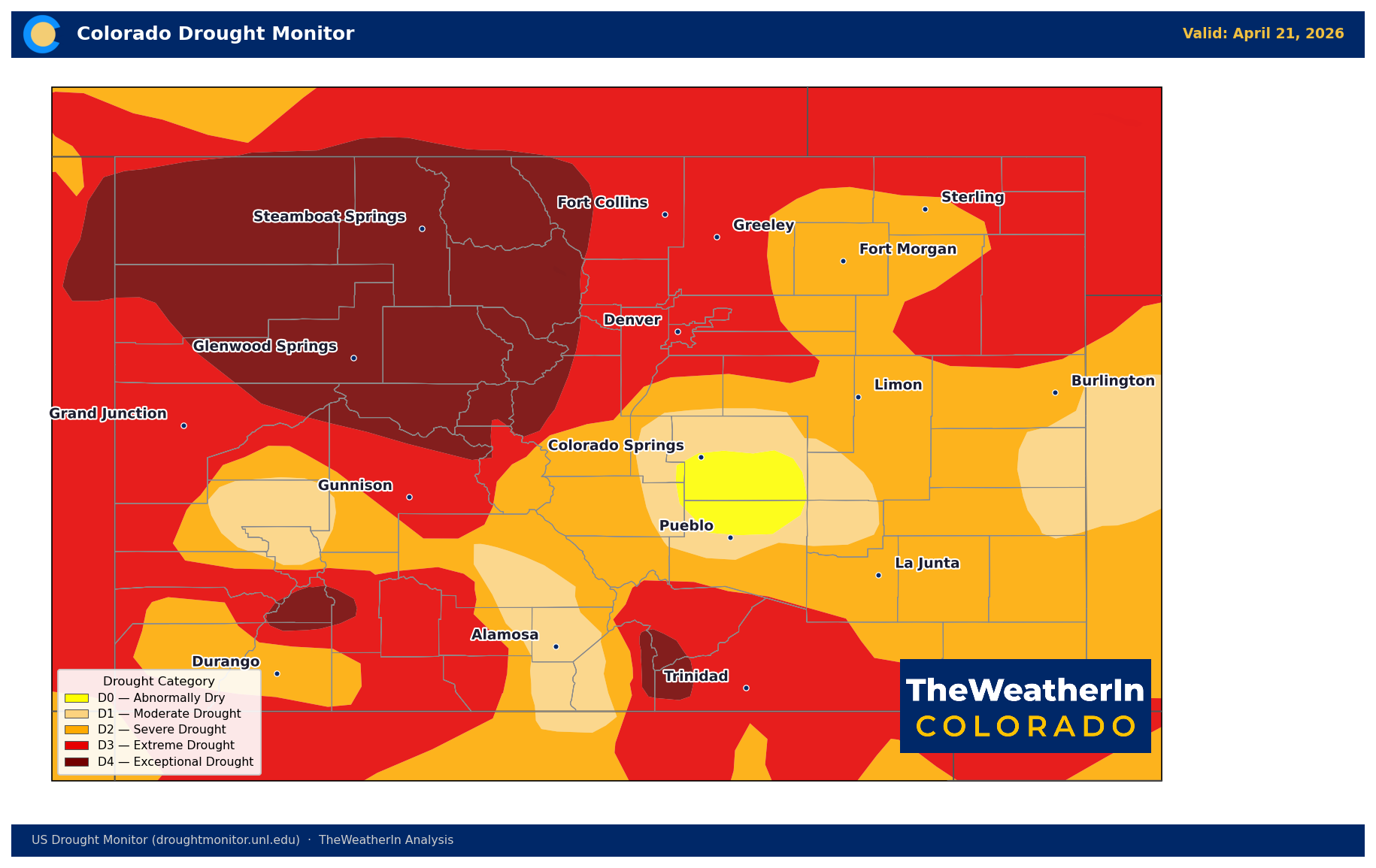
Drought conditions range from Abnormally Dry (D0) to Moderate to Severe Drought (D2–D3) across Colorado, with the San Luis Valley and southeastern corner carrying the worst conditions statewide. This is not a new story — drought has been building since late fall — but it is accelerating.
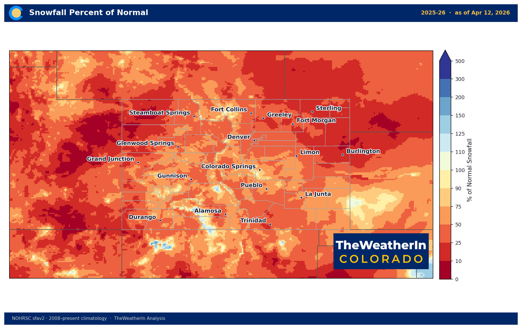
Statewide snowpack is running at 50 to 75 percent of normal, and with temperatures above normal since late March, the melt is happening 2 to 3 weeks ahead of schedule. That means peak runoff — the window when mountain snow transitions into river flows — will arrive earlier than normal, and the overall runoff volume will be lower. Reservoirs that depend on late-spring snowmelt to fill will end the season below average. Water managers, irrigators, and municipalities drawing from mountain-fed systems should plan for lower-than-normal late-summer storage.
The weekend system will add some snowpack above 9,000 feet, but not enough to close the deficit meaningfully. The next real drought-busting opportunity would likely require multiple storm systems tracking through Colorado during May — a scenario that forecast data does not currently support.
Wildfire Outlook
April 2026 is tracking as one of the most active fire weather months on record in Colorado. The combination of early snowmelt, cured vegetation, persistent wind events, and extreme temperature departures has produced a sequence of Red Flag conditions that would be more typical of June or July. That calendar shift is the core concern going forward: if fire weather this intense is occurring in April, when vegetation is still partially green, what does June look like when fuels are at peak dryness?
The fire risk does not decline meaningfully through May. Fuels will continue to cure. The monsoon — which typically provides the best moisture relief to southern Colorado — is not expected to arrive early. The most dangerous conditions will likely occur with the return of strong downslope wind events, which are common on the Front Range and Eastern Plains through late spring.
Agricultural Implications
- Frost risk through mid-May: Despite the warmth, a late freeze remains possible — particularly in the San Luis Valley, mountain parks, and high-elevation basins. The weekend system will push temperatures back to near-normal levels, and a hard freeze in the Valley remains a possibility May 1–15. Do not assume the warm spring has eliminated frost risk.
- Soil moisture and pasture: Topsoil moisture is running short to very short across most of the Eastern Plains and portions of the Western Slope. Pasture conditions are deteriorating faster than normal for this time of year. Producers should assess hay inventory now — a difficult summer on pasture is the base case, not the risk case.
- Irrigation timing: Early peak runoff means earlier junior water rights curtailments are possible on some drainages. Irrigators on fully-appropriated streams should monitor calls closely through June rather than waiting for the typical July pressure point.
- Wind damage: The extended period of strong downslope and westerly winds is a direct threat to soil in tilled fields and orchards. Wind erosion conditions are active or likely.
Recreation Planning
Skiing: good luck at this point...
Hiking and trail running: trails above treeline are likely to be snow-free weeks ahead of normal, but afternoon thunderstorm season will begin earlier as well. Above-treeline exposure risk increases as we move deeper into May. Check trail conditions carefully; the warm, open conditions can change abruptly when storms pop up.
Fishing: early runoff means peak flows on most major rivers will arrive 2 to 3 weeks ahead of schedule. Anglers targeting pre-runoff conditions should act soon — the window is narrowing on many Front Range and Western Slope streams.
The signal to watch going forward: monsoon onset timing. If the summer monsoon arrives on schedule or early — typically mid-July for southern Colorado — it will provide the best opportunity to break the fire weather and drought cycle before August. A late or weak monsoon extends the high-risk period well into fall. We will track this signal closely through June and July.
Published April 23, 2026 — Updated from the original April 12 outlook.

Conditions as of April 22, 2026.