Late-Season Snow and Freeze Arrive — But Drought Runs Deeper
A late-April storm brings mountain snow and plains freeze risk this week — meaningful, but not nearly enough to dent Colorado's record drought heading into summer.
Late-Season Snow and Freeze Risk Arrive — But the Drought Story Runs Much Deeper
A welcome burst of late-April cold and moisture arrives this week — mountain snow, scattered valley showers, and a widespread freeze threat Friday night — but the near-term pattern is best understood as a brief interruption to one of the most serious drought situations Colorado has seen in decades, not a turning point in it.
Pattern Overview
A series of weak shortwave troughs — essentially small dips in the upper-level flow rotating through the southwestern U.S. — will keep Colorado cool and unsettled through Friday. This isn't a dramatic, high-impact storm; it's a classic late-spring disturbance that delivers meaningful snowfall to the high country and scattered showers to lower elevations before a high-pressure ridge builds in over the weekend. The ridge brings a brief warmup and drying, before the next round of moisture approaches early next week.
The larger driver behind this pattern is a Rex block — a configuration where a strong ridge sits over the western U.S. with a deep low-pressure system anchored over eastern Canada. This setup tends to funnel weaker Pacific systems into the Southwest rather than allowing strong, moisture-laden storms to penetrate the Rockies. The result is exactly what we've seen: alternating short wet and dry periods, with moisture amounts that are helpful at the margins but far below what's needed to address structural deficits.
The important context here is what this week's system cannot do. Colorado's snowpack closed out April 1 (typical peak) at just 22% of the long-term median — the lowest on record going back to the 1930s. Southern basins fell to single digits. The window for meaningful snowpack recovery is closed. Whatever falls in the mountains this week adds modest late-season moisture to soils, but the water supply picture for the 2026 irrigation season was locked in weeks ago. Precipitation helps; it does not reverse what a historically warm, dry winter failed to deliver.
Weeks Ahead: 2–4 Week Outlook
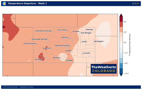
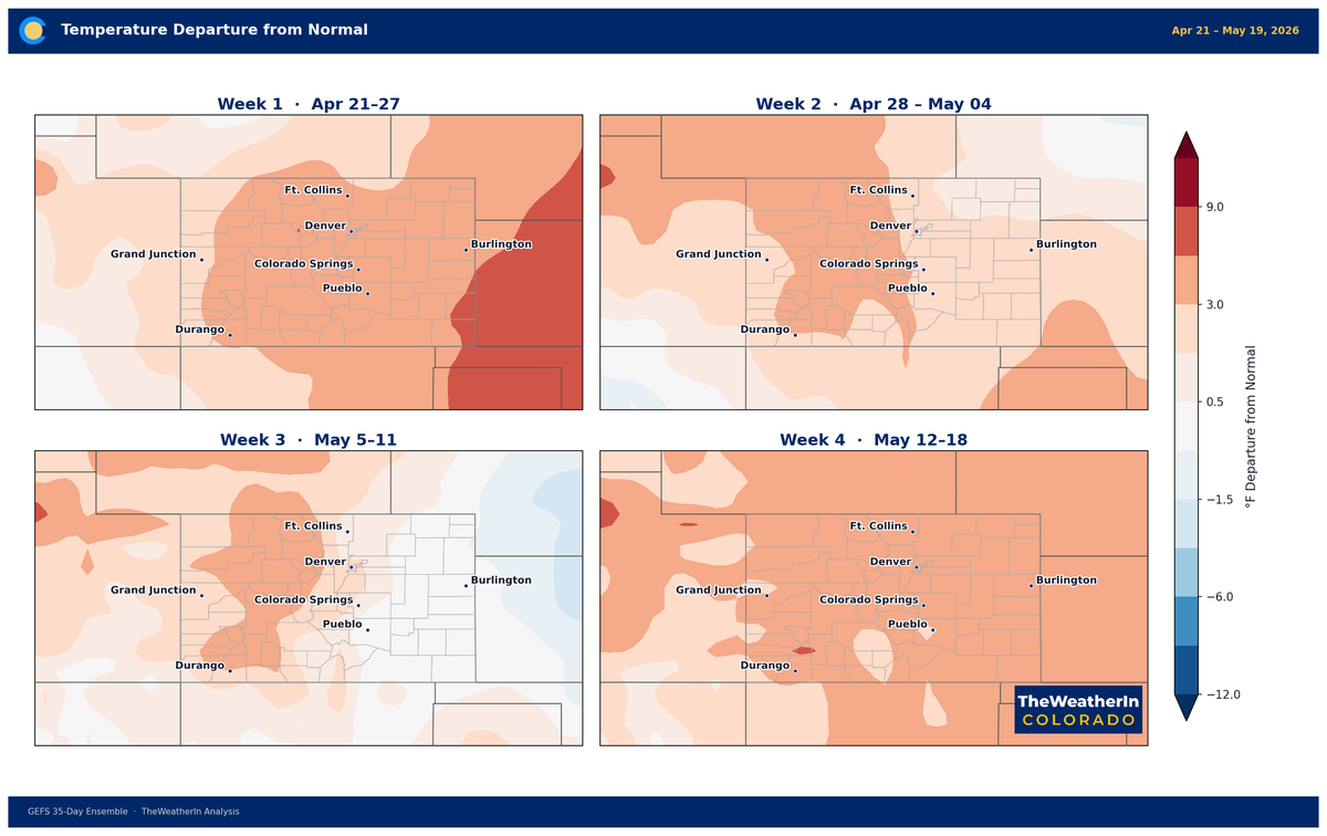
Heading into the first two weeks of May, forecast data shows Colorado remaining in a transition zone — caught between an upper-level trough over eastern North America and a developing western ridge. The near-term result is continued day-to-day variability: temperatures running near to slightly below normal through May 5, a brief warmup around May 6–8 as the ridge strengthens, then a return toward near or below normal May 9–12 as the next Pacific system approaches. No sustained heat is expected in this window, but no sustained state-wide wet pattern is developing either.
The larger climate driver — the fading of La Niña and the gradual transition to a neutral Pacific pattern — is unfolding, but it is doing so. This transition historically loosens the warm, dry grip on southern Colorado, and that's a legitimate signal for the coming months. However, May is not yet showing the decisive, coordinated moisture return Colorado needs. Scattered showers over weak disturbances are the forecast signal for early May, not broad, drought-busting rainfall. The pattern improvement, when it comes, will be measured in weeks and months — not days.
Beyond two weeks, the seasonal outlook for May through July favors continued warmth and a gradual trend toward more precipitation as the monsoon pattern establishes. This is meaningful progress compared to the grip of La Niña that drove December through March's historically unprecedented warmth — but ranchers, irrigators, and water managers should plan around continued tight water supplies through the 2026 growing season regardless of what late spring brings.
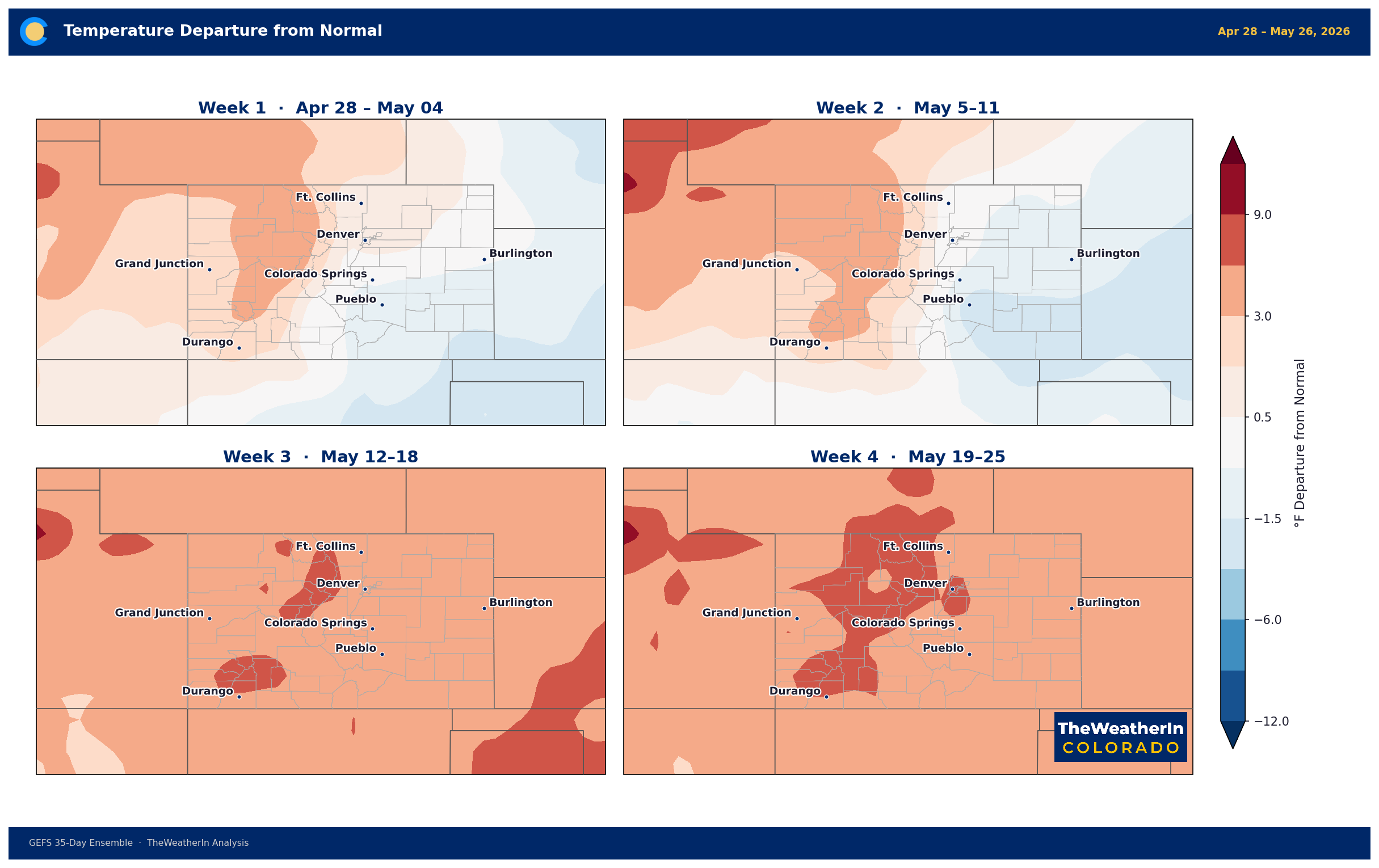
Four-week temperature anomaly outlook. A brief warmup this weekend gives way to a return to near-normal temperatures through mid-May.
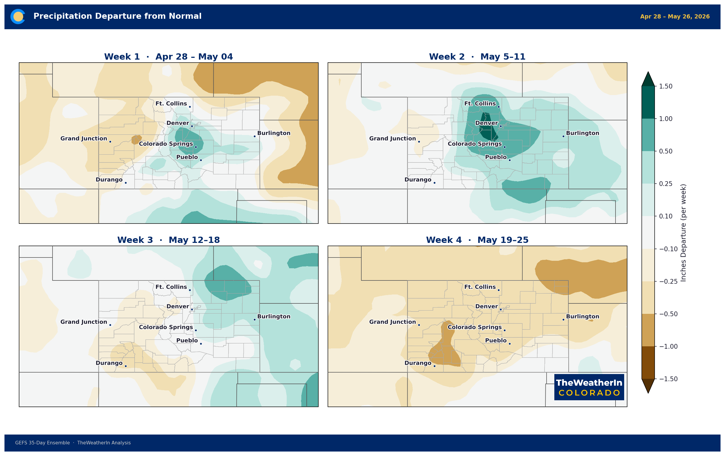
Four-week precipitation anomaly outlook. No strong wet signal is evident for the period; scattered disturbances favor modest, variable precipitation rather than sustained above-normal totals each week.
Regional Breakdown: April 29 – May 4
| Region | Temperature | Precipitation | Highlights |
|---|---|---|---|
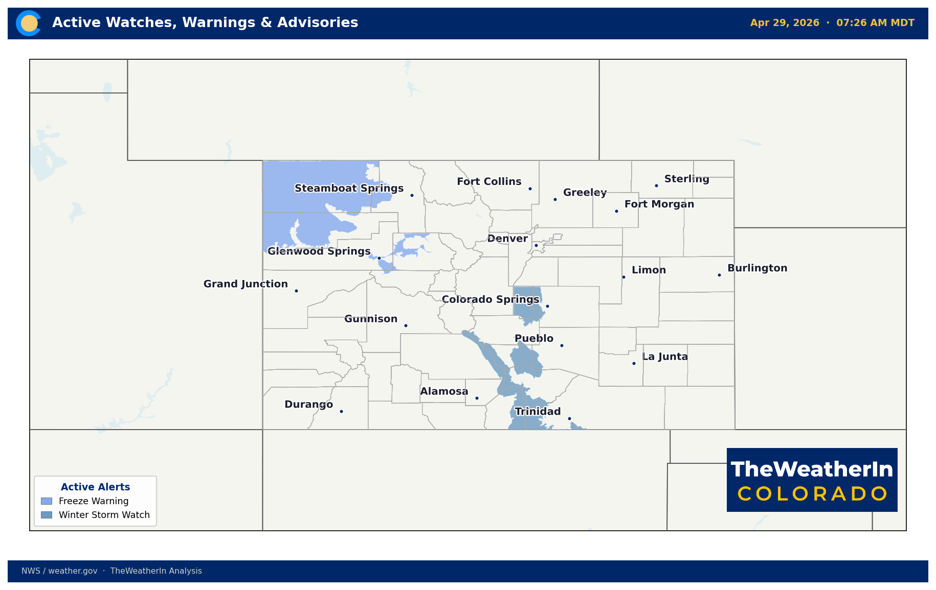
| Front Range / Foothills | 4–6°F below normal Wed–Fri; near 70°F by Sunday | 0.20–0.60" QPF; 6–12" snow above 7,000 ft Thu–Fri | Freeze risk Friday night; warming weekend |
| Mountains / High Country | Below normal through Friday; Freeze Warnings (western divide) through Wed morning | 10–20" above 8,500 ft (eastern/southern ranges); snow levels to 6,500 ft overnight Thu–Fri | Heaviest snow Thu night–Fri morning; isolated small hail possible with stronger cells today |
| Western Slope | Below normal Wed–Fri; Freeze Warnings (Yampa/Central Basin) through Wed morning | Isolated showers; light snow above 8,000 ft; heaviest moisture focuses south | Warming, drier weekend; another system possible mid next week |
| Eastern Plains | Below normal Wed–Fri; widespread freeze Friday night | Light showers today; minimal QPF Thu–Fri (bulk stays over foothills/mountains) | Freeze threat is the primary concern; critical for early-season crops and pastures |
| Southern CO / San Luis Valley | Below normal Wed–Fri; snow levels 8,000–9,000 ft Thu, falling to 7,000 ft Fri; widespread freeze Friday night | 1.0–1.5" QPF in southeast mountains; 6–12" snow higher elevations; 0.50–1.0" elsewhere | Best precipitation of the event for this region; scattered afternoon showers possible Sat–Sun over mountains |
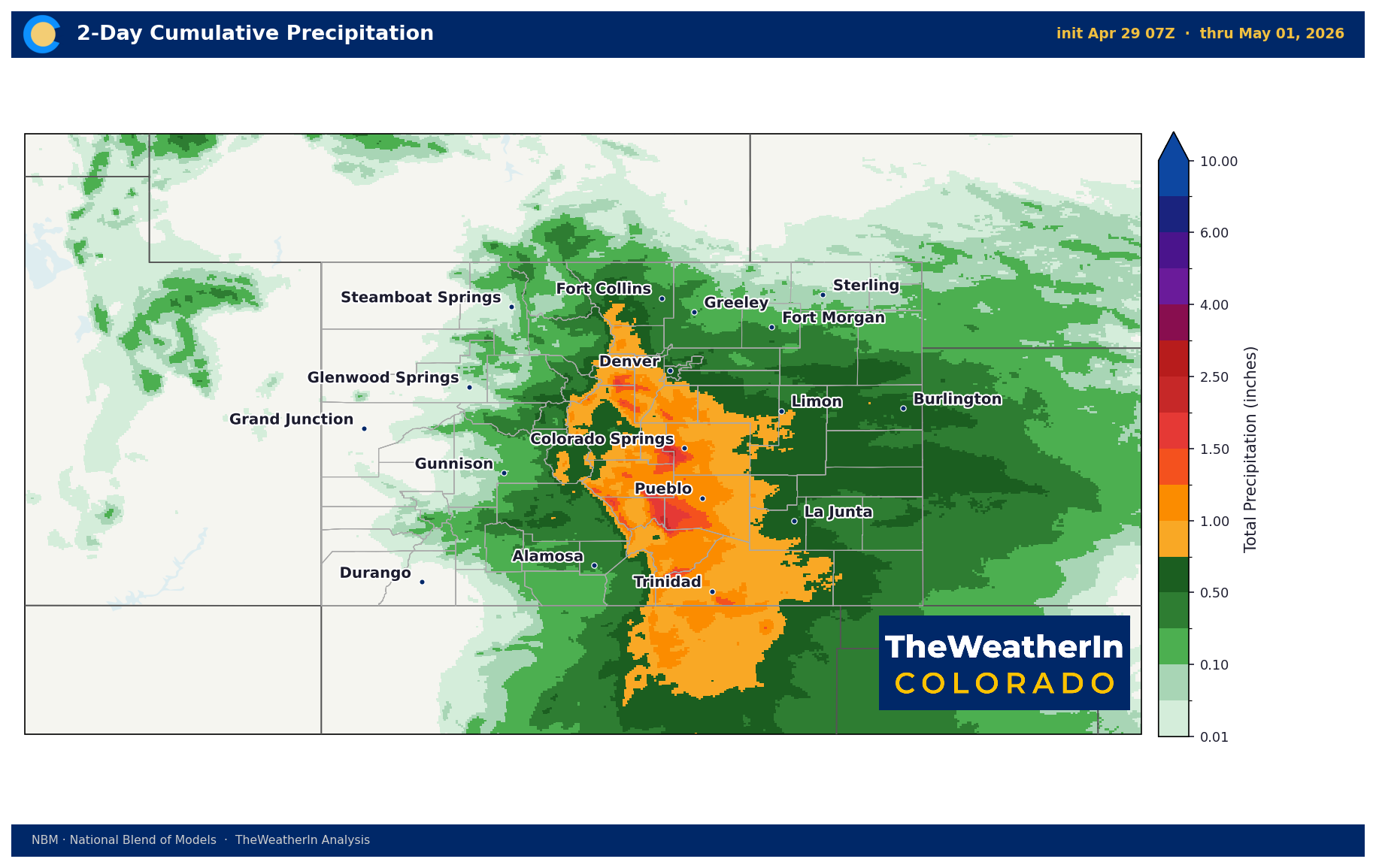
Forecast precipitation for Thursday — the primary moisture day for most of Colorado. Southern and mountain areas see the heaviest totals.
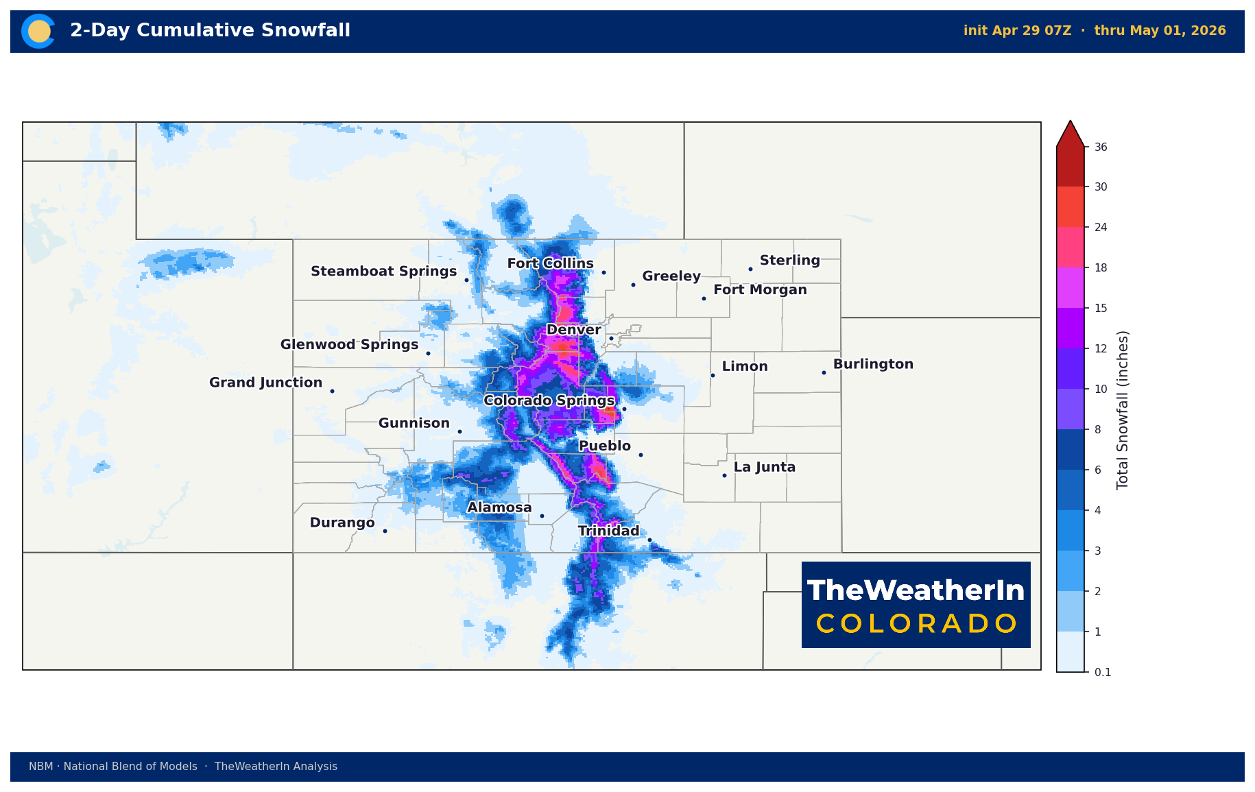
Forecast snowfall for Thursday. Higher terrain in southern and eastern ranges will see the most significant accumulations.
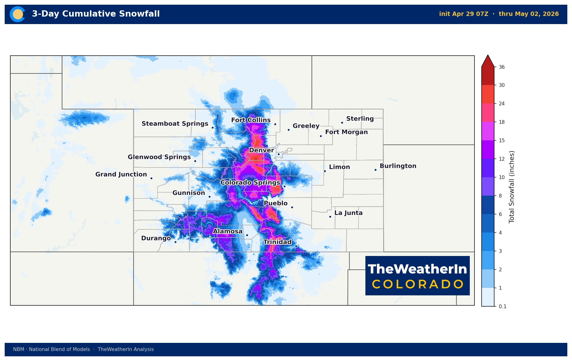
Forecast snowfall for Friday. Snow levels drop overnight, expanding accumulation potential at mid-elevations.
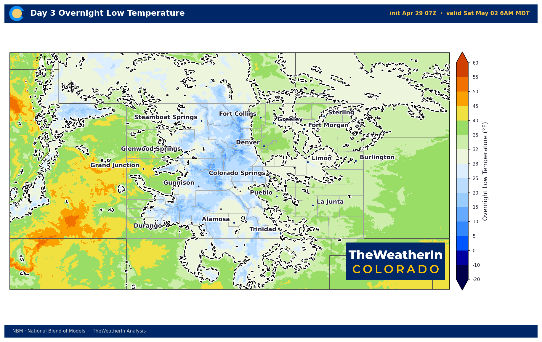
Forecast minimum temperatures for Friday night. Freeze conditions are likely across the southeastern plains, the San Luis Valley, and valley floors statewide.
Drought & Water
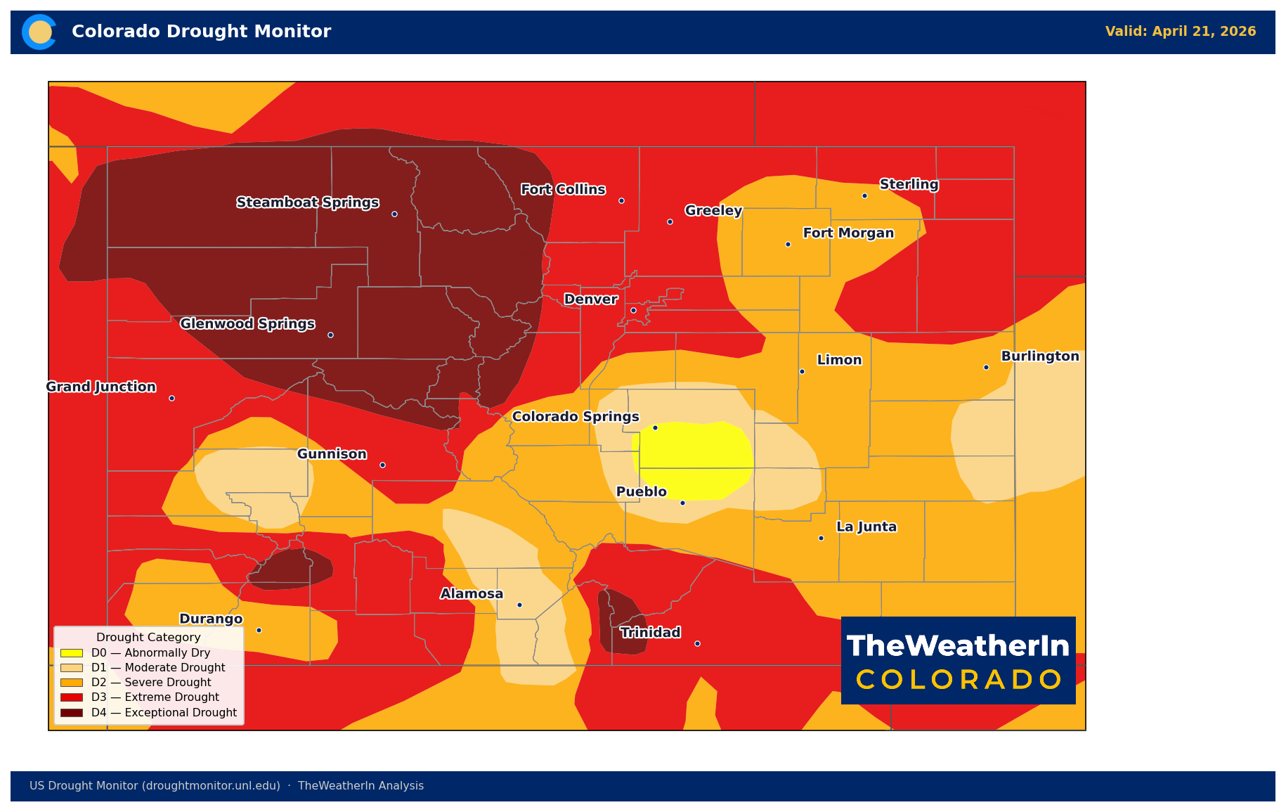
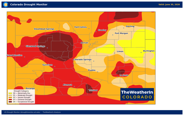
U.S. Drought Monitor for Colorado as of April 21, 2026. No part of the state is drought-free; 98% is in at least moderate drought (D1), and nearly 58% in extreme or exceptional drought (D3–D4).
The current drought situation is among the most severe Colorado has recorded. As of April 21, every square mile of the state is at least abnormally dry, 98% is in at least moderate drought (D1 or worse), and 58% is in extreme or exceptional drought (D3–D4). That represents a dramatic deterioration from one year ago, when 44% of the state was drought-free and only about 1% was in extreme conditions. The primary cause is well-documented: an historically unprecedented warm winter drove the state's snowpack to record lows by April 1, with statewide coverage at just 22% of the long-term median — the lowest since comprehensive records began in the 1930s.
This week's precipitation will provide localized soil moisture benefit — particularly in southern Colorado, where QPF totals of 0.50–1.50" represent meaningful relief for the driest soils. Mountain snow adds late-season water equivalent to the high country. But the structural deficit in water supply for 2026 is not a problem that scattered late-April showers can solve. Peak snowmelt runoff arrived weeks ahead of schedule this spring, and streamflow into reservoirs has run well below expectations. The irrigation season water supply gap is locked in.
The weekly trend as of April 21 showed drought conditions continuing to expand and intensify — the Drought Severity and Coverage Index (DSCI, a composite measure of drought extent and intensity) rose from 357 to 367 in a single week, and stands at more than triple where it was three months ago. The next U.S. Drought Monitor update will be the first signal of whether this week's precipitation creates any measurable improvement, particularly in southern Colorado. Do not expect dramatic category changes from a single event of this magnitude given the depth of the existing deficit.
Agricultural Implications
- Freeze threat Friday night is the most immediate concern for producers. Widespread temperatures at or below freezing are expected across the southeastern plains, San Luis Valley, and valley floors statewide. Any early-season greens, spring blooms, or newly emerged pasture grass are at risk. Cover what you can; plan for a hard freeze check Saturday morning.
- Precipitation this week provides modest soil moisture benefit on the plains, more meaningful relief in southern Colorado. Dryland operations in eastern Colorado will see little direct benefit from this event — most QPF stays over the foothills and mountains. Below-normal soil moisture across eastern dryland areas entering late April remains a concern heading into the growing season, and the longer-range pattern through May does not show a strong, coordinated wet signal to reverse it.
- Wind and fire weather are not concerns through Friday, giving some breathing room after a difficult spring for fire risk. The warming and drying trend this weekend and into early next week will allow fire danger to tick back up gradually — not to critical levels immediately, but worth monitoring as the drying pattern reasserts itself and the calendar moves deeper into fire season.
Watch through May: As La Niña's influence fades and the Pacific pattern transitions toward El Niño, the outlook for late spring and early summer becomes incrementally less certain on the dry side — but May forecast data does not yet show the coordinated moisture return Colorado's drought-stressed landscape needs. The water supply picture for 2026 is the story to follow all season long until we see how well the monsoon can deliver.