
Colorado Summer Outlook 2026 — Warmer Than Normal, With a Monsoon Wildcard
El Niño is confirmed and already shaping Colorado's summer pattern. Above-normal temperatures are the high-confidence call. The precipitation story is more nuanced — and neither changes the drought outlook on its own.

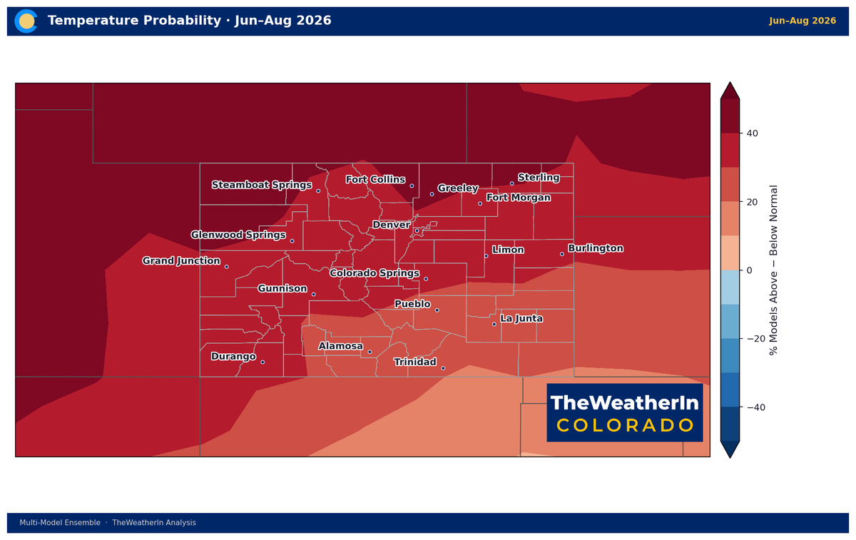
El Niño arrived in the tropical Pacific last month, and it's already leaving fingerprints on Colorado's summer pattern. The latest seasonal forecast data points firmly toward above-normal temperatures through summer, a modest above-normal precipitation signal driven largely by the monsoon, and a drought footprint that won't budge meaningfully until fall at the earliest — if then.
What's Driving This Summer's Pattern
El Niño conditions were confirmed in the June 11 advisory — and the climate system is responding. Above-average sea surface temperatures across the central and eastern tropical Pacific are generating the atmospheric circulation changes that define El Niño's global weather fingerprint. For Colorado, the translation is a summer pattern that leans warmer than normal statewide, with above-normal precipitation favored primarily across southern Colorado and the San Luis Valley — the regions where Colorado's summer monsoon delivers its most consistent moisture.
The monsoon is Colorado's primary summer precipitation mechanism, and El Niño historically amplifies it. Warmer tropical Pacific SSTs increase moisture flux out of the Gulf of Mexico and Gulf of California, deepening the moisture plume that flows north into the Four Corners region and beyond. That signal shows up clearly in the seasonal data — but geography matters enormously. The monsoon's reach fades quickly north of the Arkansas River drainage. The Front Range corridor, northern mountains, and eastern plains carry a smaller above-normal precipitation signal and are more likely to land near the historical average for summer. Individual thunderstorm distribution patterns add another layer of variability that seasonal forecasts cannot resolve.
The temperature signal carries no such ambiguity. Above-normal temperatures are favored at 84% probability through June–August and 83% through July–September. The warmer the summer, the higher the evapotranspiration demand — which means any precipitation that does arrive faces a steeper climb before it benefits soils, rivers, or drought conditions.
Temperature Outlook
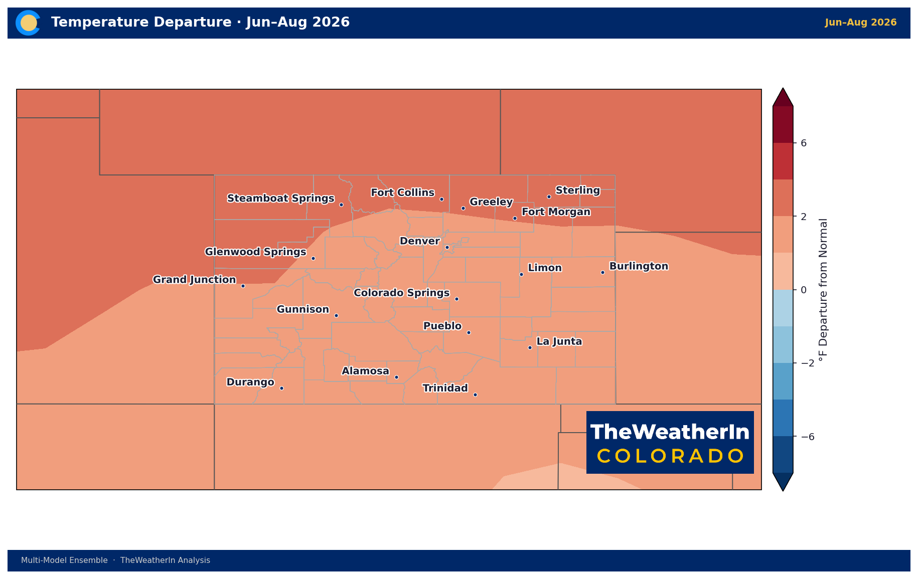
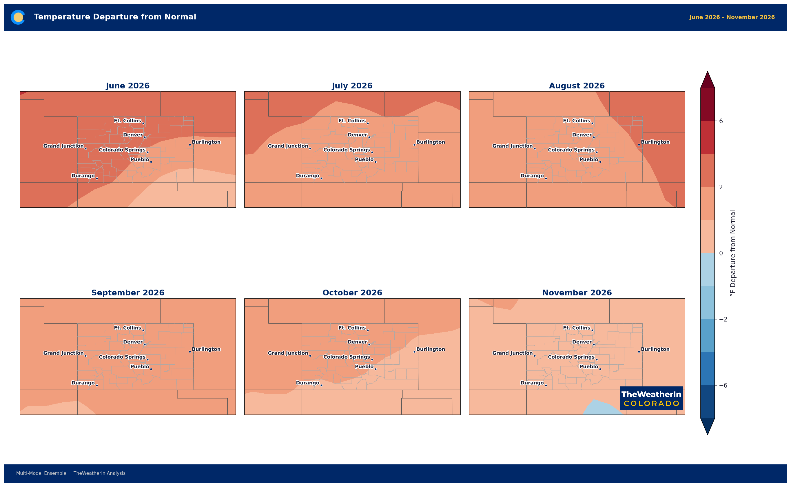
The statewide temperature anomaly averages roughly 1.8°F above the 30-year normal for June through August, with the warmest departures concentrated in southwestern and southern Colorado — approaching 2.5°F above normal in the most anomalous areas. That signal moderates slightly through July–September (1.5°F statewide) and again into August–October (1.3°F). The direction is consistent and high-confidence throughout: no part of Colorado shows a meaningful probability of a cooler-than-normal summer.
Precipitation Outlook and the Monsoon
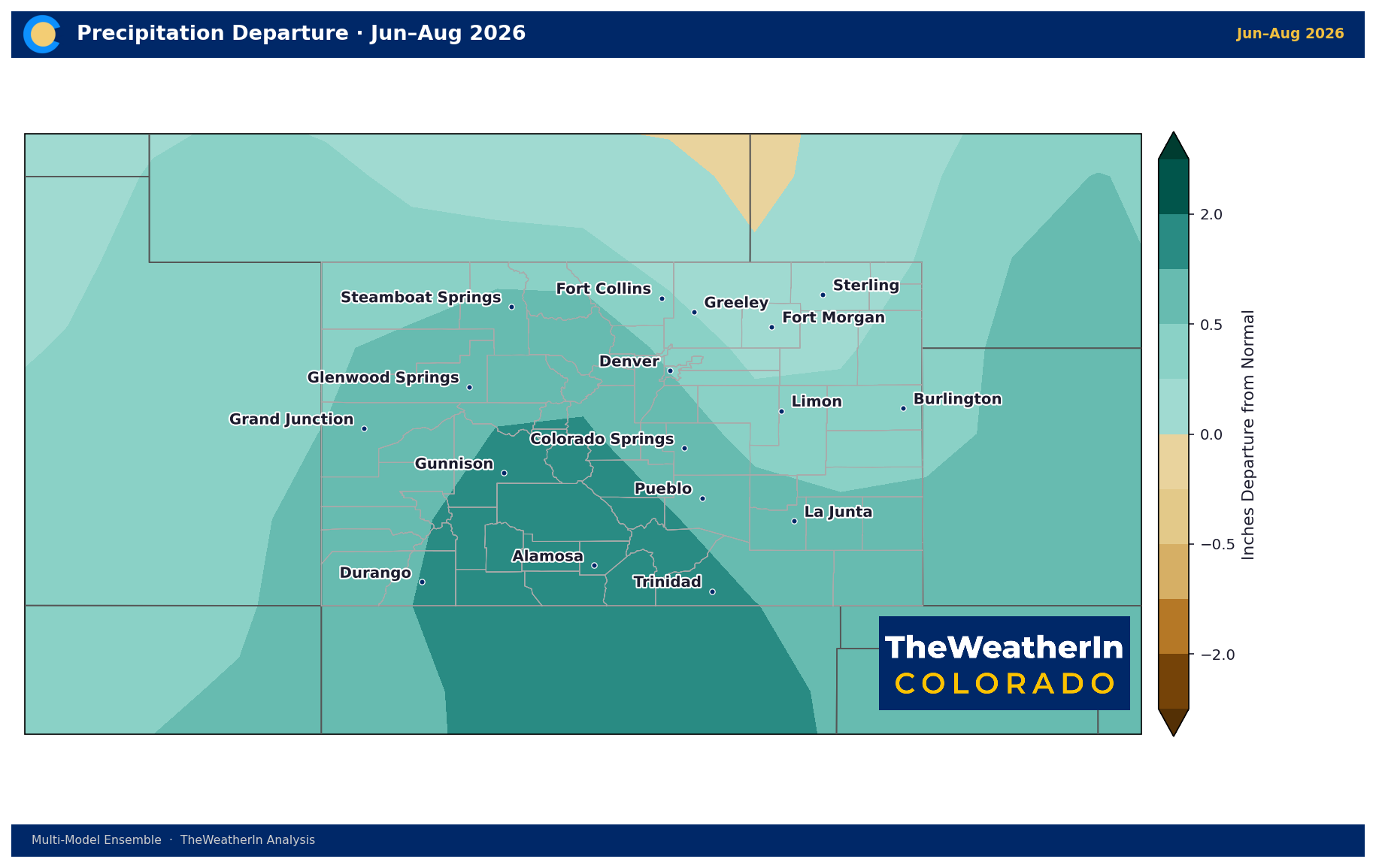
The precipitation outlook leans above normal through summer, with the signal strengthening over time. The June–August period carries a 68% probability of above-normal precipitation statewide; that rises to 74% for July–September and 82% for August–October. The magnitude is modest — roughly 0.7 to 1.0 inch above normal over the three-month period — but the direction is consistent with what an El Niño-enhanced monsoon historically delivers.
The regional picture is where this forecast gets more specific. Southern Colorado and the San Luis Valley — already the most drought-stressed areas of the state — are also the areas positioned to receive the most consistent monsoon benefit. The precipitation anomaly narrows toward zero across the northern mountains and much of the eastern plains and Front Range, where the monsoon arrives with less regularity. An above-normal summer precipitation outlook statewide does not mean above-normal precipitation everywhere in Colorado.
Regional Summer Outlook
| Region | Temperature | Precipitation | Key Factor |
|---|---|---|---|
| San Luis Valley & Southern CO | Above normal (+2–2.5°F) | Above normal — strongest monsoon signal | Monsoon most consistent here; some surface relief to drought during active events |
| SE Colorado & Southern Plains | Above normal (+1.5–2.5°F) | Near to above normal (monsoon-dependent) | Convective events possible but erratic; heat stress on livestock and dryland crops |
| Front Range & Northern Plains | Above normal (+1.5–2°F) | Near normal | Limited monsoon reach; elevated irrigation demand with no water supply flexibility |
| Western Slope & Four Corners | Above normal (+1.5–2°F) | Near normal to slightly above | Continued severe drought; river flows remain near record lows through summer |
| Mountains & High Country | Above normal (+1–2°F) | Near normal | No snowpack recovery possible; drought persists through all mountain basins regardless of summer precip |
Drought & Water: Why Summer Won't Be the Turning Point
The combination of above-normal temperatures and slightly above-normal precipitation sounds like progress — and for the monsoon-favored portions of southern Colorado, it may provide some localized surface relief. But the math of this drought doesn't work in summer's favor. The statewide water supply deficit built over the past year — the lowest snowpack on record, May–July runoff forecast at 24% of normal, a Drought Severity Index that has more than doubled in 12 months — cannot be meaningfully reversed by an inch or two of above-normal summer precipitation. Warmer temperatures simultaneously increase the demand that any arriving moisture must satisfy.
What summer's above-normal precipitation signal actually represents is a slower rate of deterioration in the most monsoon-exposed regions, not recovery. Rivers won't refill from afternoon thunderstorms. Deep soil moisture deficits won't close in a season. The drought footprint on the September map will look much like the June map, though isolated localized improvements are possible in the heaviest monsoon zones.
The fall-to-winter transition is where the meaningful drought story begins. A strengthening El Niño — now expected to rank among the strongest on record, with a 63% probability of a very strong event by late fall — historically delivers above-normal precipitation to the southern Rockies from November through March. That's the window where a sustained wet pattern could begin making a real dent in a deficit that has no modern parallel in Colorado's climate record.
Agricultural Implications
- Irrigation demand will increase through summer as above-normal temperatures drive higher evapotranspiration rates — precisely when water supply allocations are most constrained. Producers operating on surface water rights across the Arkansas, Gunnison, and Colorado basins are already at severely reduced delivery; peak summer heat will stress systems with no remaining flexibility.
- The monsoon is a genuine bright spot for southern Colorado ranchers and dryland producers. An above-normal monsoon signal translates to better odds for forage recovery and stock water availability in the San Luis Valley and southeastern Colorado — the areas that have seen some of the deepest drought intensification this spring. The forecast does not extend that confidence north of the Arkansas River watershed.
- Fire weather risk doesn't disappear with an above-normal precipitation outlook. Even in a favorable monsoon summer, Colorado will experience extended dry, hot, and windy periods between convective events — particularly in June before the monsoon fully establishes. Fire risk diminishes during active monsoon phases and rebounds between them. The record-low fuel moisture conditions that produced the Sharpe Fire in May have not improved.
The signal worth watching this fall is whether the strengthening El Niño maintains its grip on the Pacific as the storm track shifts south — that's the setup that has historically delivered the kind of sustained, snowpack-building precipitation Colorado needs to begin reversing what 2025–26 left behind.



