Colorado Weather Outlook — April 12, 2026
Fire weather headlines this weekend across southern Colorado and the eastern plains, with a much-needed system arriving Tuesday before another potential snow event closes out the week.

Fire Weather: The Immediate Concern
Active Red Flag Warnings are in effect across southern Colorado and portions of the eastern plains through this evening, with another round expected Monday. Winds are gusting 25 to 35 mph at lower elevations across southern Colorado, with mountain gusts exceeding 40 mph in some areas. Relative humidity values are critically low — fuels are extremely dry after a warm, dry stretch that has run well above normal temperatures for weeks.
The fire threat extends into Monday, with Red Flag conditions forecast to continue across the same areas. Southern Colorado residents and landowners should avoid any ignition sources through Monday evening. The western slope near the Yampa River Basin is also seeing gusts up to 50 mph today — a Wind Advisory is in effect for that area.
A cold front arriving Monday night into Tuesday will end the immediate fire threat for most of the state, though fire danger is expected to rebuild by Thursday.
This Week: A Welcome System Tuesday, Then More Heat
The pattern turns active Tuesday as an upper-level trough moves across Colorado. A cold front will push through Tuesday afternoon and evening, bringing rain to lower elevations and snow to mountain passes. National Weather Service forecasters note advisory-level snowfall is becoming increasingly likely for mountain zones, with a 50 to 75 percent chance of six inches or more in favored terrain above 7,000 feet. Expect minor travel impacts on mountain passes Tuesday.
By Wednesday, cooler and drier conditions settle in statewide — a brief break before the heat returns.
Thursday and Friday bring another round of above-normal temperatures and elevated fire danger as southwest flow strengthens again ahead of the next system. Late Friday into Saturday, a potentially stronger upper-level trough moves through, bringing another shot of cold air and precipitation. National Weather Service forecasters are watching this system closely — mountain snow is possible, though track and timing details remain uncertain at this range.
Temperature Departure from Normal
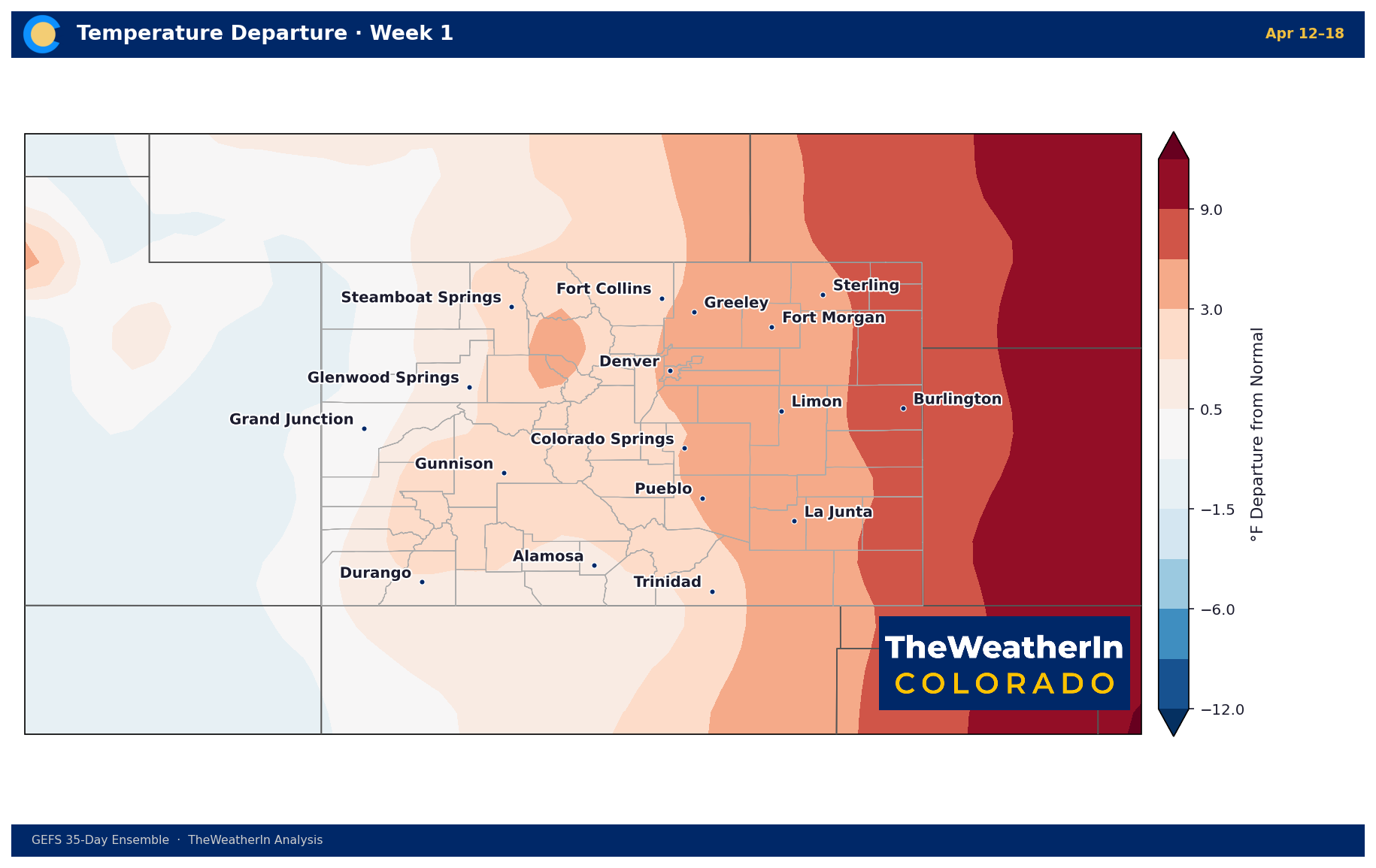
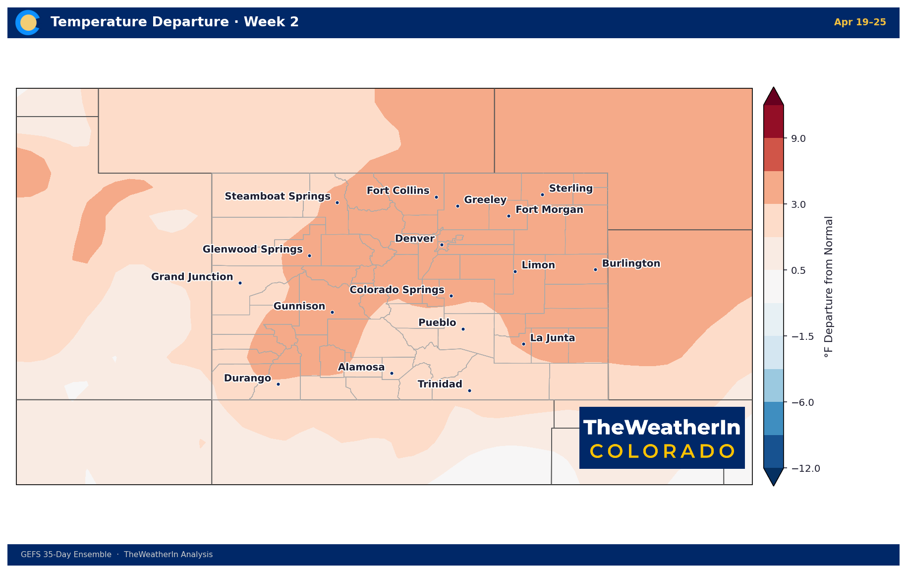
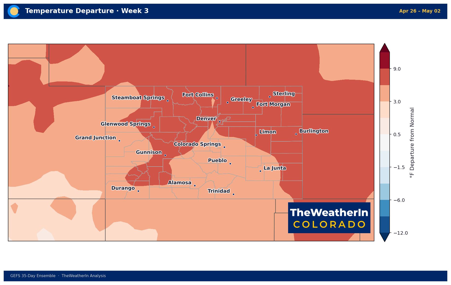
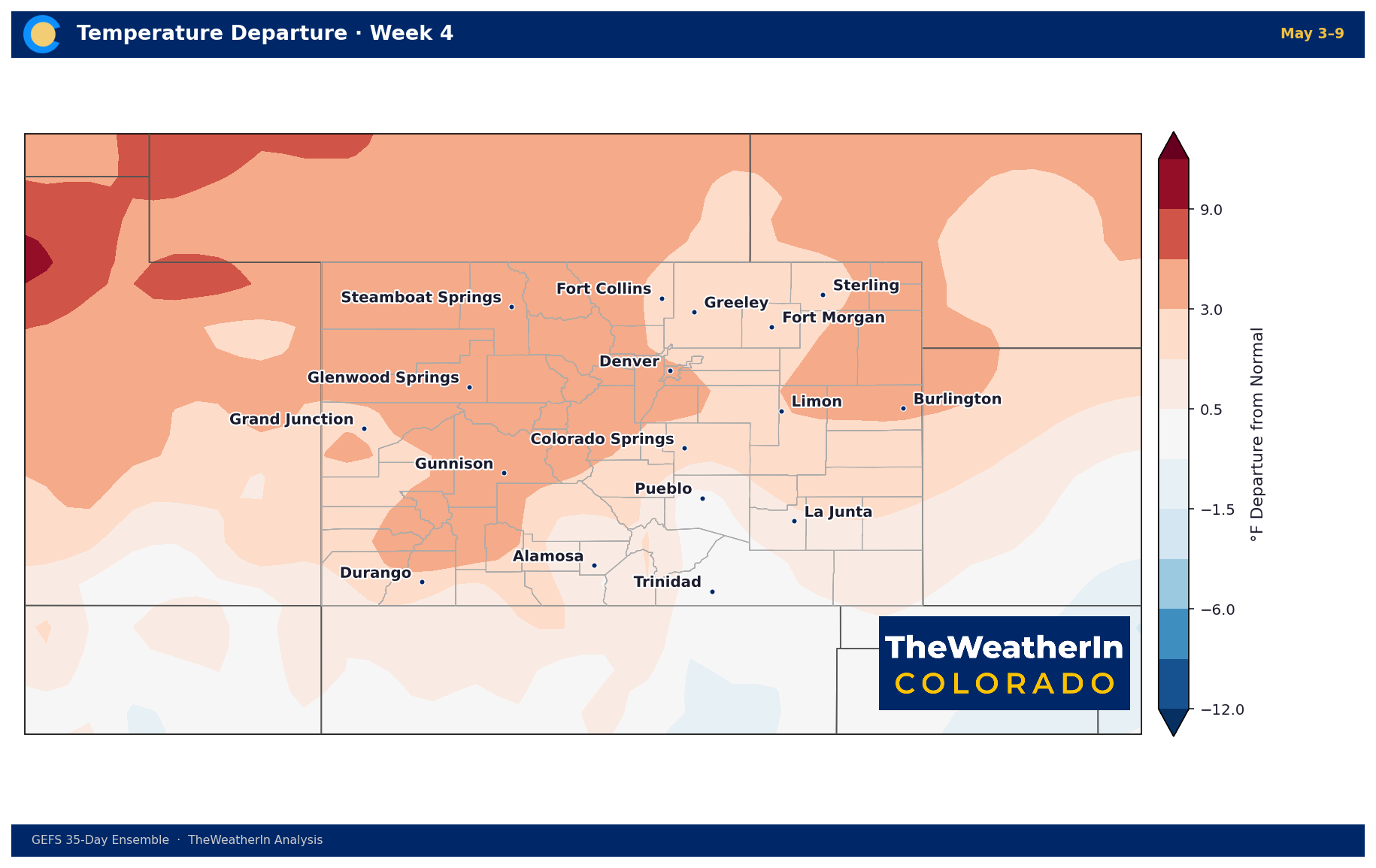
The warm pattern that has dominated Colorado for weeks continues through at least late April. Temperatures are running 3 to 7 degrees above normal across most of the state this week, with the strongest anomalies on the eastern plains. The warmth intensifies in Week 3 before beginning to moderate in early May.
| Location | Apr 12–18 | Apr 19–25 | Apr 26–May 2 | May 3–9 |
|---|---|---|---|---|
| Denver | +4.3°F | +4.6°F | +5.8°F | +2.6°F |
| Fort Collins | +3.2°F | +3.6°F | +6.6°F | +2.8°F |
| Colorado Springs | +4.6°F | +4.3°F | +5.5°F | +2.2°F |
| Pueblo | +3.6°F | +2.3°F | +3.9°F | −0.4°F |
| Burlington | +6.9°F | +4.3°F | +7.4°F | +3.4°F |
| Steamboat Springs | +2.4°F | +3.3°F | +7.4°F | +6.0°F |
| Gunnison | +2.8°F | +4.3°F | +6.2°F | +4.0°F |
| Grand Junction | 0.0°F | +2.1°F | +5.1°F | +3.4°F |
| Durango | +1.6°F | +2.6°F | +4.1°F | +1.7°F |
| Alamosa | +1.2°F | +1.6°F | +2.6°F | −0.1°F |
Precipitation Departure from Normal
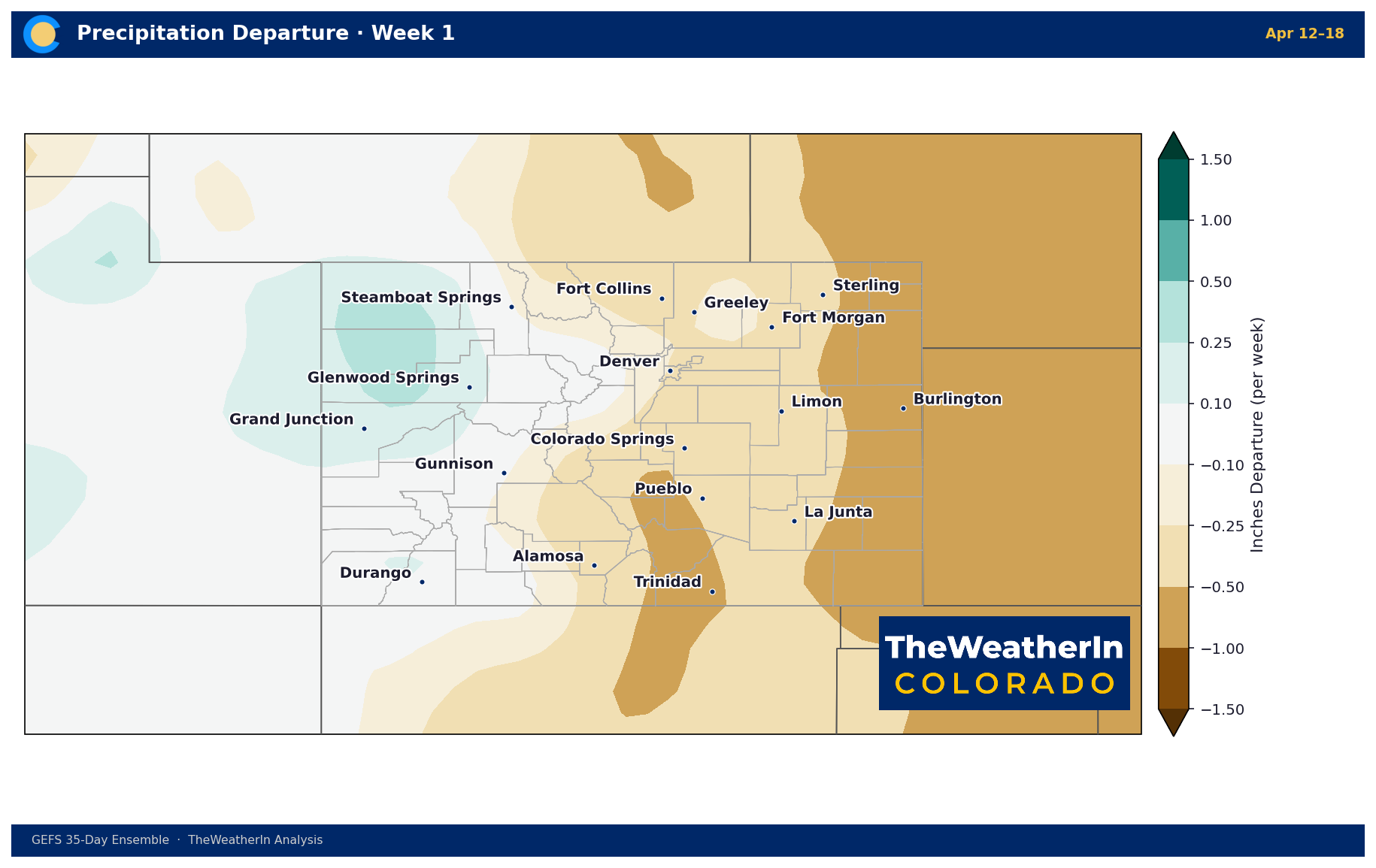
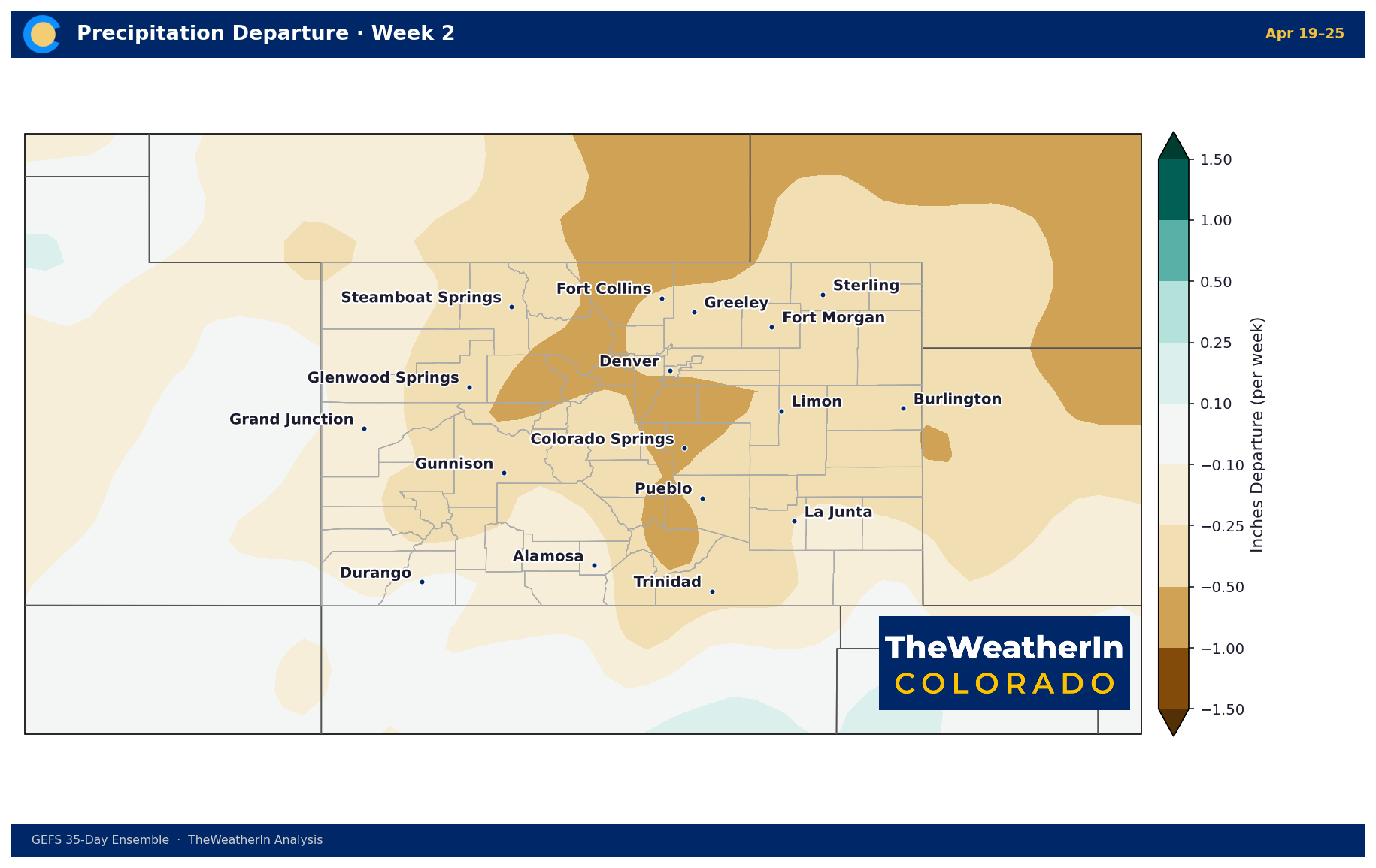
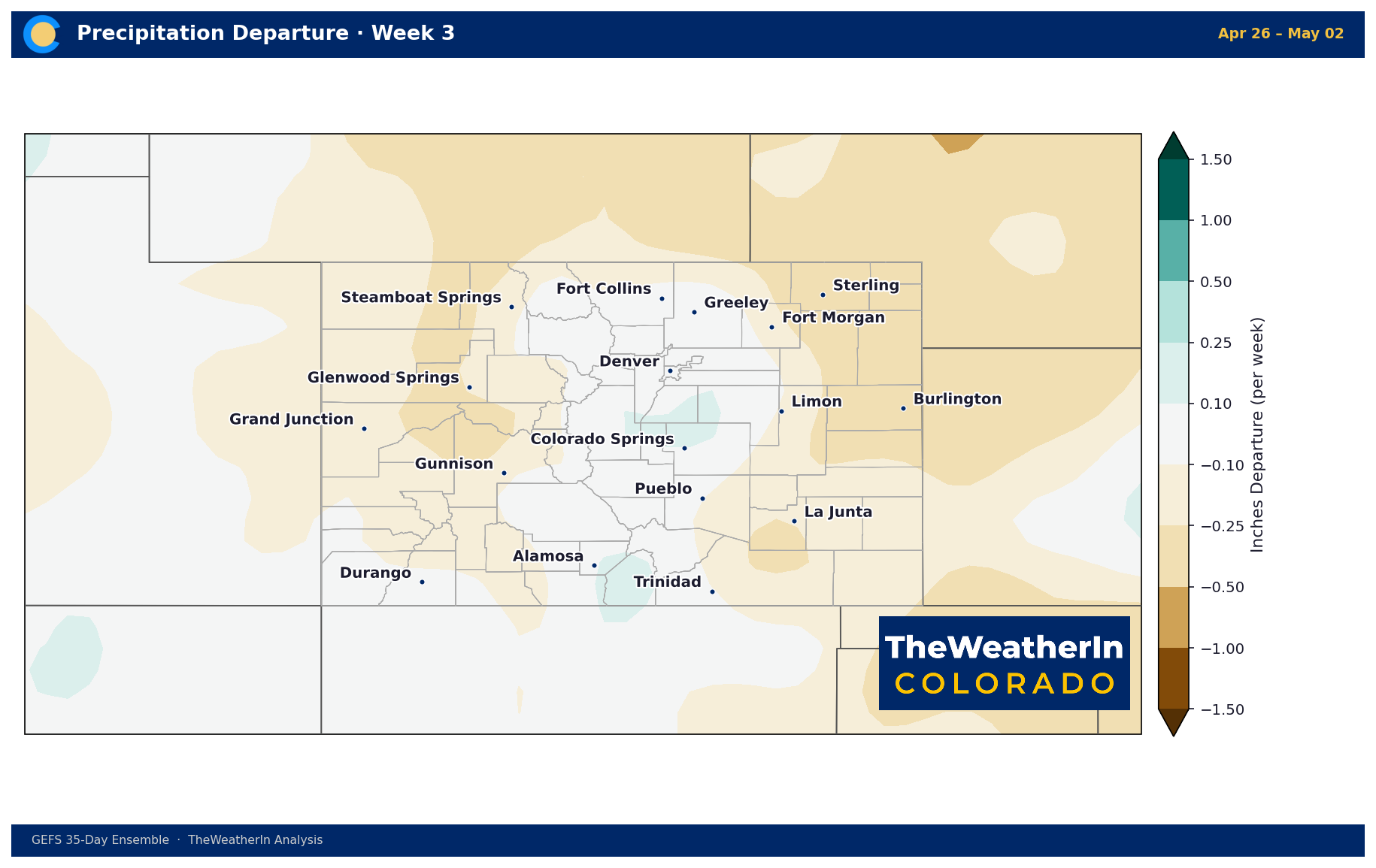
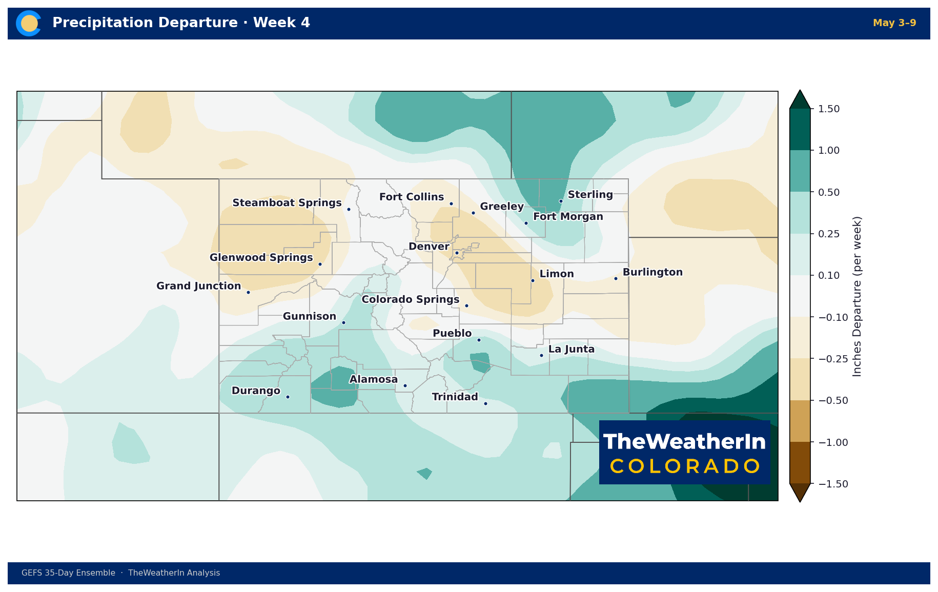
Precipitation runs below normal for most of the state through the first two weeks, driven largely by the warm, dry pattern ahead of Tuesday's system. The eastern plains carry the largest deficit — Burlington is running nearly 0.8 inches below normal for Week 1. Some modest positive signals emerge in Weeks 3 and 4, particularly for southern Colorado and the western slope.
| Location | Apr 12–18 | Apr 19–25 | Apr 26–May 2 | May 3–9 |
|---|---|---|---|---|
| Denver | −0.2" | −0.5" | 0.0" | −0.3" |
| Fort Collins | −0.3" | −0.4" | 0.0" | −0.3" |
| Colorado Springs | −0.5" | −0.5" | +0.1" | −0.2" |
| Pueblo | −0.4" | −0.3" | −0.1" | +0.5" |
| Burlington | −0.8" | −0.5" | −0.4" | −0.1" |
| Steamboat Springs | −0.1" | −0.4" | −0.1" | 0.0" |
| Gunnison | −0.1" | −0.2" | −0.1" | +0.2" |
| Grand Junction | +0.2" | −0.2" | −0.2" | −0.3" |
| Durango | +0.1" | −0.1" | +0.1" | +0.5" |
| Alamosa | −0.2" | −0.2" | +0.2" | +0.1" |
Departures in inches per week.
Bottom Line
Fire safety is the priority through Monday across southern Colorado and the eastern plains. Tuesday's system brings meaningful relief — mountain snow and lower-elevation rain — but the warm, dry pattern reasserts quickly. Watch for a potentially more significant mountain snow event Friday night into Saturday. The extended outlook keeps Colorado well above normal through late April before the warmest signal of the period arrives in Week 3, centered on the northern mountains and eastern plains.