Colorado's Hottest Summer on Record Gives Way to a Wetter, Warmer Fall
Summer 2026 is now in the books as the hottest climatological summer Colorado has ever recorded, and the forecast data suggests fall won't offer a clean break from that pattern, even as the moisture picture starts to shift in a more favorable direction.

Summer 2026 is now in the books as the hottest climatological summer Colorado has ever recorded, and the forecast data suggests fall won't offer a clean break from that pattern, even as the moisture picture starts to shift in a more favorable direction.
Summer 2026: The Hottest on Record
June, July, and August together averaged 4.9°F above the 20th-century normal and 3.4°F above the more recent 1991–2020 average, enough to beat the previous warmest summer on record, 2012, by a full 0.7°F. The western two-thirds of the state each had their own individual hottest summer on record; only the Eastern Plains came in "merely" top-10 warm. August itself was the standout: the hottest August on record statewide, tied for the 4th-warmest of any of the 132 years' worth of calendar months on the books, and every part of the state, Front Range, mountains, and Western Slope alike, set its own individual record for the month. That extends Colorado's streak of above-average months to 15 in a row.
The heat came with real consequences beyond the numbers. Colorado logged three separate four-day heat waves in August alone, bringing the year's total to seven, the most in a single year with data back to 1951. Three of the eight hottest four-day stretches on record, statewide, have now happened in 2026. State extremes for the month: a high of 110°F at Las Animas on August 8 (tied again on August 10), a low of 23°F at Cowdrey on August 6, and a single-day rainfall record of 3.92 inches at a CoCoRaHS station near Kiowa on August 15.
Precipitation was more of a mixed bag. Summer overall ran drier than average - the 22nd-driest on record, with central and southern Colorado especially parched, but a handful of Eastern Plains locations bucked the trend with repeated intense thunderstorms. August itself finished modestly dry statewide, and the San Luis Valley, usually Colorado's wettest month of the year, had one of its driest Augusts on record.
Fall Outlook: September Through November
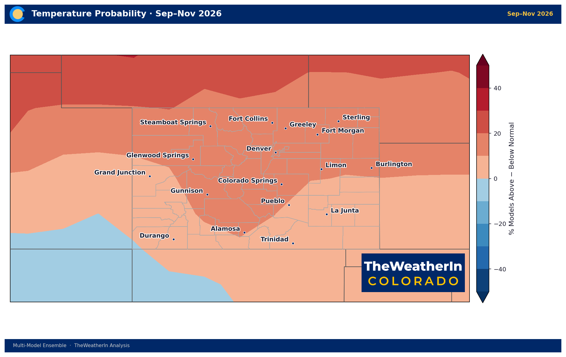
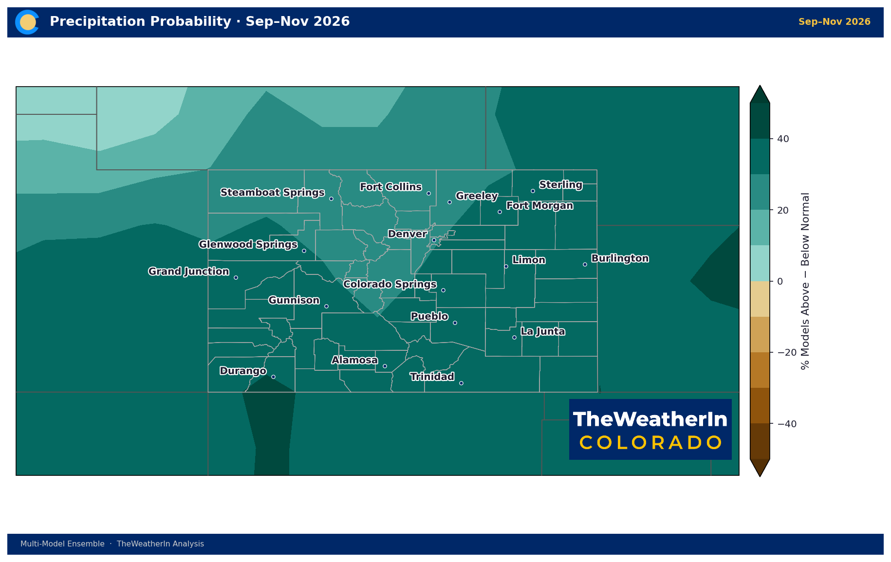
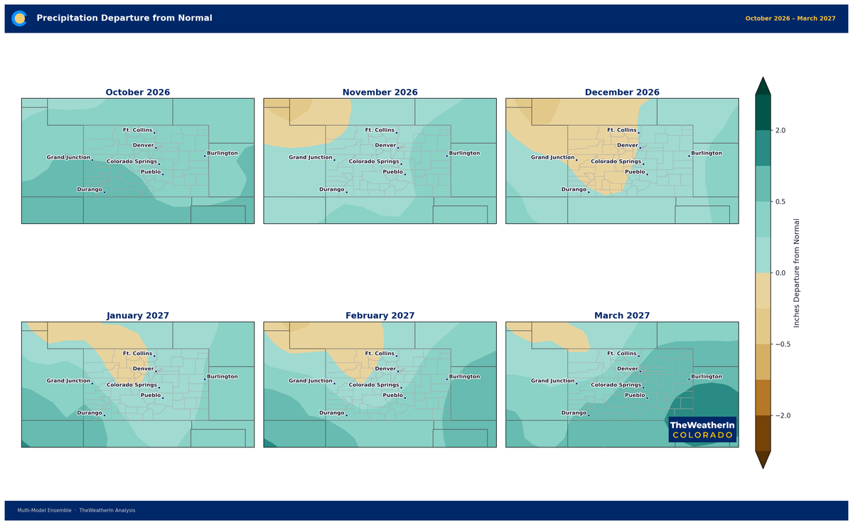
The forecast data for the three months ahead shows the warm streak isn't over yet, but it comes paired with a real shift toward wetter conditions, a meaningfully different combination than the hot, dry summer just wrapped up. Statewide, the ensemble leans about 1.4°F above normal for the September–November period, with roughly three in five members favoring above-normal temperatures. On the moisture side, the signal is stronger and more consistent: better than four in five ensemble members favor above-normal precipitation, averaging close to an inch per month wetter than the seasonal norm.
| Region | Temperature (Sep–Nov) | Precipitation Lean |
|---|---|---|
| Front Range / Urban Corridor | +1.6°F, 63% lean warm | 81% lean wet |
| Eastern Plains | +1.6°F, 62% lean warm | 85% lean wet |
| Western Slope | +1.3°F, 59% lean warm | 82% lean wet |
| San Luis Valley | +1.3°F, 61% lean warm | 83% lean wet |
| Southern Mountains / San Juans | +1.2°F, 57% lean warm | 89% lean wet |
Why Fall Looks Different From Summer
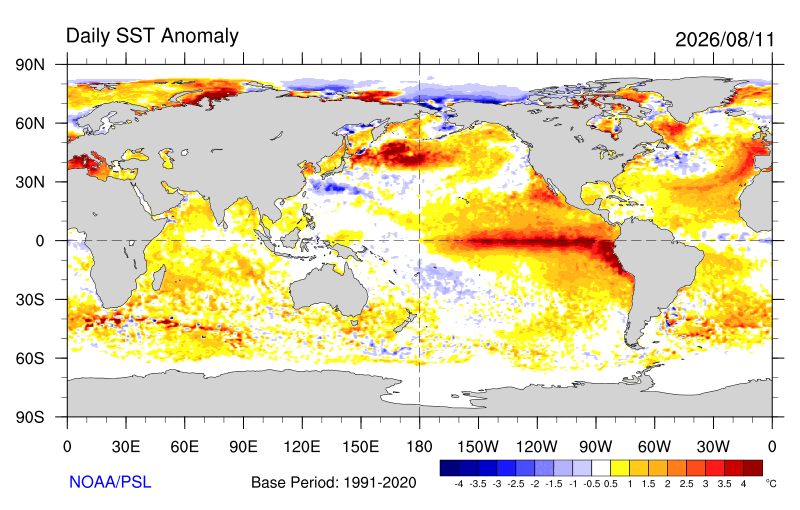
The warmth carrying over from summer is the easy part to explain; a 15-month above-average streak doesn't reverse on a calendar flip. The moisture shift is the more interesting story. It's arriving just as a rapidly strengthening warm-water pattern in the tropical Pacific, favored to become one of the strongest on record by winter, starts nudging the broader storm track in a wetter direction for the Rockies and Southwest. That signal typically strengthens as fall turns to winter, and the data above already hints at where it's showing up first: the southern mountains, where nearly 9 in 10 ensemble members lean wet.
Drought & Water
Colorado's drought footprint remains extensive heading into fall; 93.81% of the state was in at least abnormal dryness as of the September 8 update, with 87.95% in moderate drought or worse and 46.68% in extreme-to-exceptional drought. That's essentially unchanged from a week earlier at the top end, even as the worst categories ticked slightly higher. The wetter fall lean above is a genuinely positive signal, but it's a start, not a fix; a single season of near-normal-to-wet conditions doesn't erase a drought built over more than a year.
Agricultural Implications
- Harvest and fall planting: A wetter-leaning fall is good news for winter wheat establishment on the Eastern Plains, where soil moisture has been a persistent concern all year.
- Rangeland recovery: Above-normal fall moisture, if it verifies, offers one last window for forage recovery before winter dormancy, particularly valuable in the San Juans and southern mountains, where the signal is strongest.
- First-frost timing: With warmth still favored statewide, there's no strong signal yet for an early frost across the Eastern Plains or San Luis Valley, worth watching as the season progresses.
The bigger story building offshore, a potentially historic warm-water event in the tropical Pacific,won't fully show its hand in Colorado until winter. Fall is the first chapter of that story, not the conclusion.