
NOAA's Latest El Niño Update: What It Means for Colorado This Winter
NOAA's August update raises the odds of a record-strength El Niño this fall — here's what that does, and doesn't, mean for Colorado.

El Niño Just Went From "Very Strong" to Possibly Record-Breaking
The tropical Pacific just delivered its clearest signal yet. NOAA's monthly ENSO update, released this morning, didn't just confirm El Niño is strengthening — it introduced a new number that hadn't shown up in any prior update this year: a two-in-three chance of a historic event this fall, one that would exceed every El Niño on record dating back to 1950.
That's a meaningful jump from where this stood even a month ago, and it changes the conversation for Colorado's winter outlook — though not the timeline.
What Changed
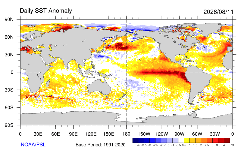
Ocean temperatures across the equatorial Pacific climbed again in July. The benchmark region forecasters watch most closely warmed to roughly 2.5°F above normal, with waters closer to South America running nearly 5°F above normal — some of the warmest readings in that region on record. Beneath the surface, a deep pool of warm water continues feeding the surface warming, which is why we expect this event to keep strengthening rather than plateau.
The atmosphere is responding in lockstep — shifting wind patterns, reorganized tropical rainfall, and pressure patterns across the Pacific are all moving together in the direction forecasters expect during a strengthening El Niño. That agreement between the ocean and the atmosphere is exactly what gives confidence in where this is headed.
The headline number: the chances are better than 9 in 10 that this becomes a very strong event by this fall and winter — and a newly introduced calculation puts the odds at 69% that it becomes the strongest event on record, surpassing the previous record-holders from the late 1990s and mid-2010s. Each monthly update since spring has raised both the probability and the ceiling of what's expected. This is not a forecast that has been trending down.
What It Means for Colorado — And When
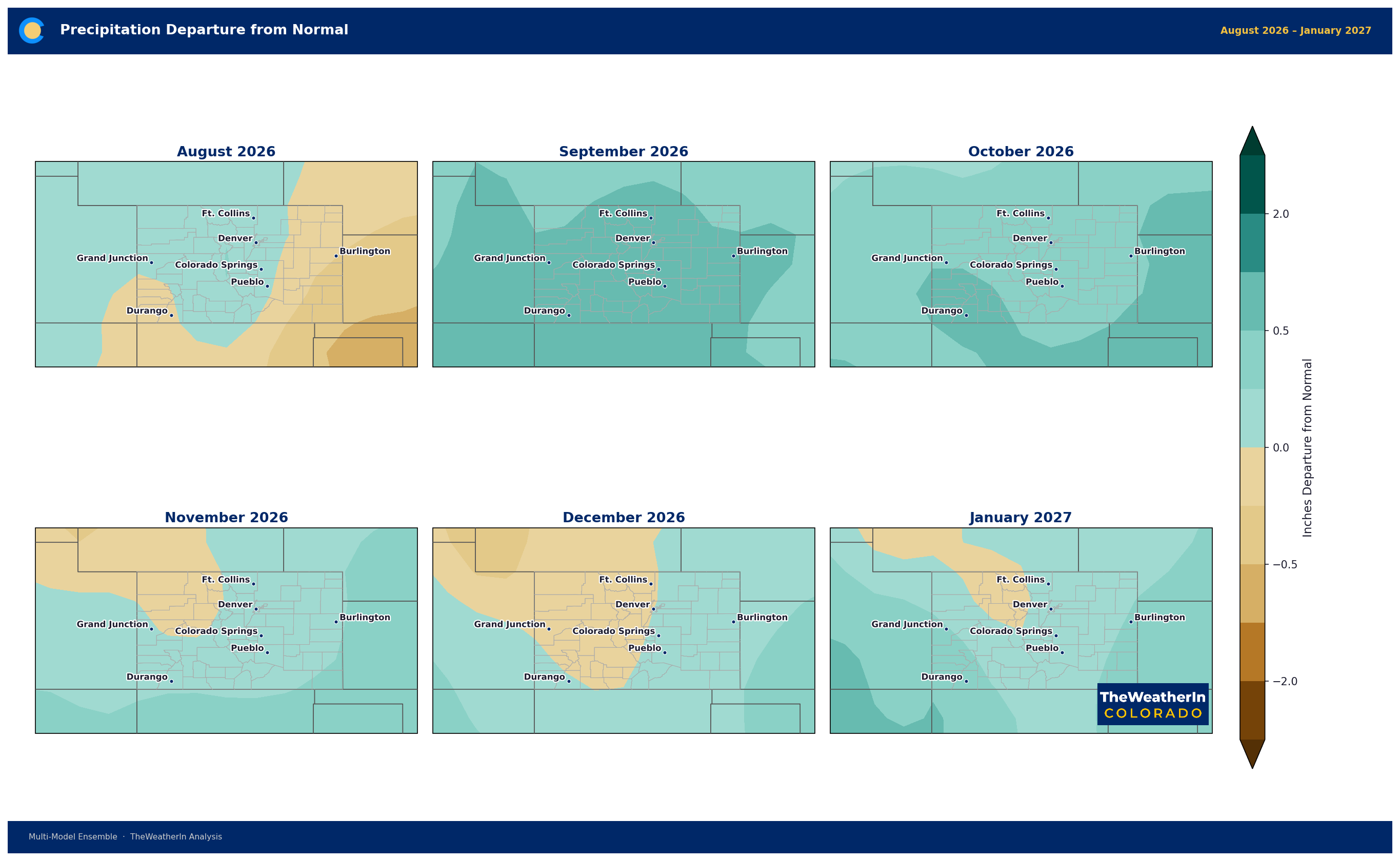
Strong El Niño winters have a well-established fingerprint across the southern Rockies: an active storm track, more frequent moisture, and a tilt toward above-normal precipitation — particularly December through March. A bigger event doesn't necessarily mean bigger regional impacts everywhere, but it does mean forecasters have more confidence the classic El Niño pattern shows up this year rather than gets overridden by something else.
Colorado's own long-range outlook data is already leaning that direction for the fall stretch immediately ahead — see the fall seasonal outlook for the specifics on temperature and precipitation tendencies through November.
Here's the part worth repeating: this is a winter story. The strongest El Niño signal, and the best chance at meaningful moisture, arrives in the October-through-March window — not this week, not this month. Colorado's drought didn't build in a season, and it won't break in one, even under a favorable pattern.
| Region | Typical El Niño Winter Tilt | Notes |
|---|---|---|
| Southern Colorado / San Luis Valley | Above-normal precipitation | Historically the most reliable wet signal in a strong event |
| Southeast Plains / Arkansas Valley | Above-normal precipitation | Active storm track favors this corridor |
| Front Range / I-25 Corridor | Leans wetter, less consistent | Benefits from an active storm track but with more variability |
| Western Slope / Mountains | Mixed signal | Snowpack response varies more event to event than the south |
| Northeast Plains | Least consistent signal | Farthest from the reliable El Niño moisture corridor |
Drought & Water
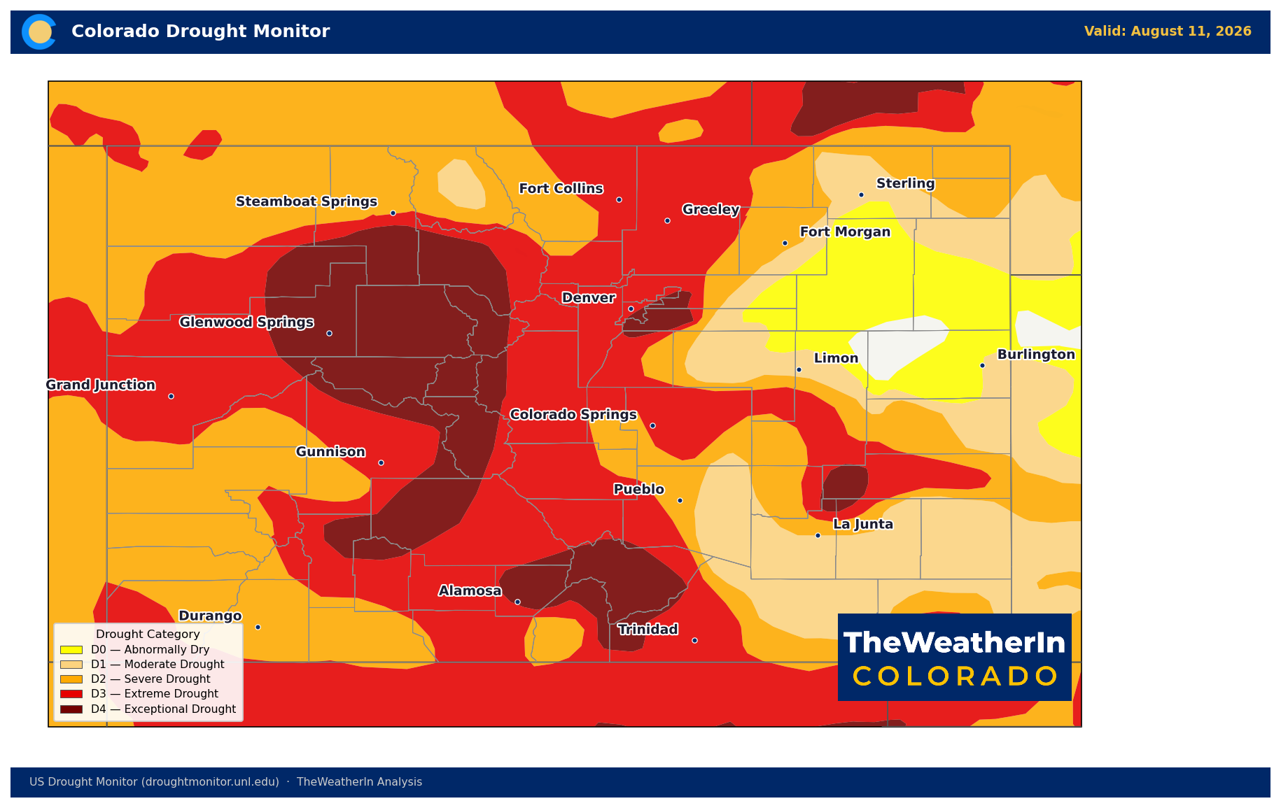
None of this changes where things stand today. Colorado's drought footprint worsened again over the past week: 99.17% of the state is now abnormally dry or worse, with 93.06% in moderate drought or deeper. That's up from 97.29% and 90.95% just seven days ago. A strengthening El Niño raises the odds of relief this winter — it does not touch the deficit sitting on the ground right now. See this week's full drought update for the complete picture.
Agricultural & Water Supply Implications
- Water managers and irrigators should treat this as a genuine reason for cautious optimism heading into winter planning — but not as a basis for near-term relief in fall allocation decisions.
- Reservoir operators drawing down carryover storage through the rest of 2026 should watch this signal closely; a strong wet season starting in November could meaningfully change spring 2027 supply projections.
- Livestock producers planning winter feed and grazing strategy have a stronger-than-usual signal to work with for December–March moisture, even though it does nothing for conditions between now and then.
The pattern shift that could finally move the needle on Colorado's drought isn't just established anymore — it's tracking toward one of the strongest events ever recorded. It's the best long-range signal Colorado has seen in this drought cycle. It just doesn't arrive for another two to three months.



