
Heat Breaks Mid-Week — But the Drought Story Is Far From Over
Extreme heat grips Colorado through Tuesday, then the monsoon arrives. The short-term relief is real — what comes after is the story worth watching.


Colorado is baking under one of the summer's most intense heat events through Tuesday — then the monsoon door opens, temperatures drop, and the state shifts into a period of widespread thunderstorms and flash flood risk. That mid-week flip is real and welcome. But for a state still locked in a historic drought emergency, one active monsoon surge doesn't move the needle much — and the pattern that follows it bears close watching.
Pattern Overview
An upper-level dome of high pressure anchored over the Four Corners is the engine behind the heat. With that ridge in place, skies clear, humidity drops, and temperatures climb well into the 90s and 100s across the plains and southern valleys. Thunderstorms can still fire in this setup — and they are — but without deep moisture to work with, the storms are high-based, meaning rain often evaporates before reaching the ground. What does reach the surface is wind: outflow gusts of 30 to 45 mph, with isolated bursts to 55 mph, are likely each afternoon and evening through Tuesday. Those winds, combined with critically dry fuels and low humidity, are enough to produce brief windows of elevated fire weather even without a formal watch or warning in place.
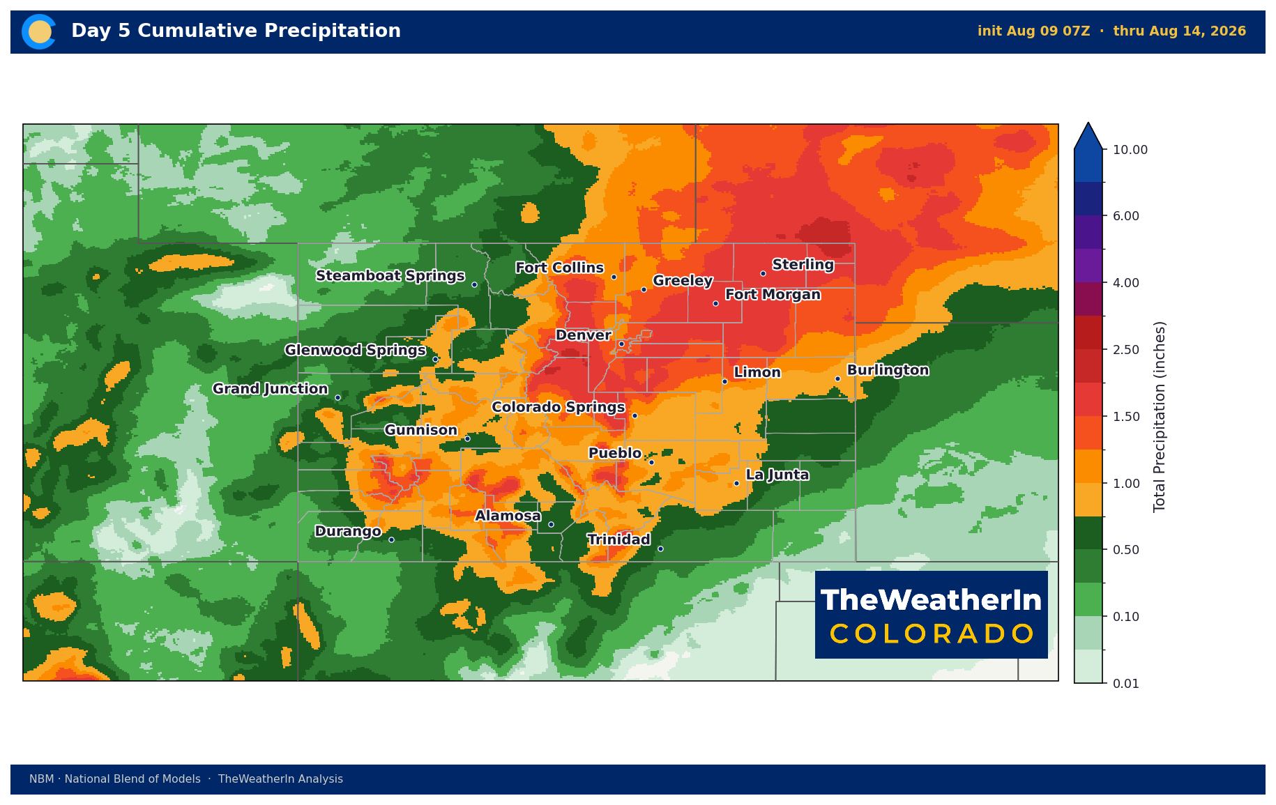
The pattern shift arrives mid-week as the ridge slides southeast. That movement opens the door for a substantial surge of monsoon moisture — forecast data shows precipitable water values (a measure of available atmospheric moisture) jumping to 130 to 180 percent of normal by Wednesday through Friday. That is a meaningful signal. Temperatures will fall 10 to 15 degrees from Tuesday's peaks, cloud cover will build, and numerous showers and thunderstorms are expected Thursday onward, with locally heavy rainfall possible. For the burn scars left by the Aspen Acres and 24 fires — and for any urban area or drainage that receives concentrated rainfall — flash flooding is the primary concern late this week. The exact storm tracks and heaviest rainfall amounts remain uncertain this far out; the setup favors the moisture, not yet the specifics.
The bigger context: this monsoon surge is arriving into a landscape that has seen little meaningful precipitation in months. Colorado's statewide drought emergency, declared in early June, has not relented. Rivers are running at or near all-time record lows. The late-week storms could provide temporary soil moisture relief in favored spots, but a single active monsoon week — even a productive one — does not begin to address a deficit of this scale. That story runs well beyond August.
Weeks Ahead: 2–4 Week Outlook
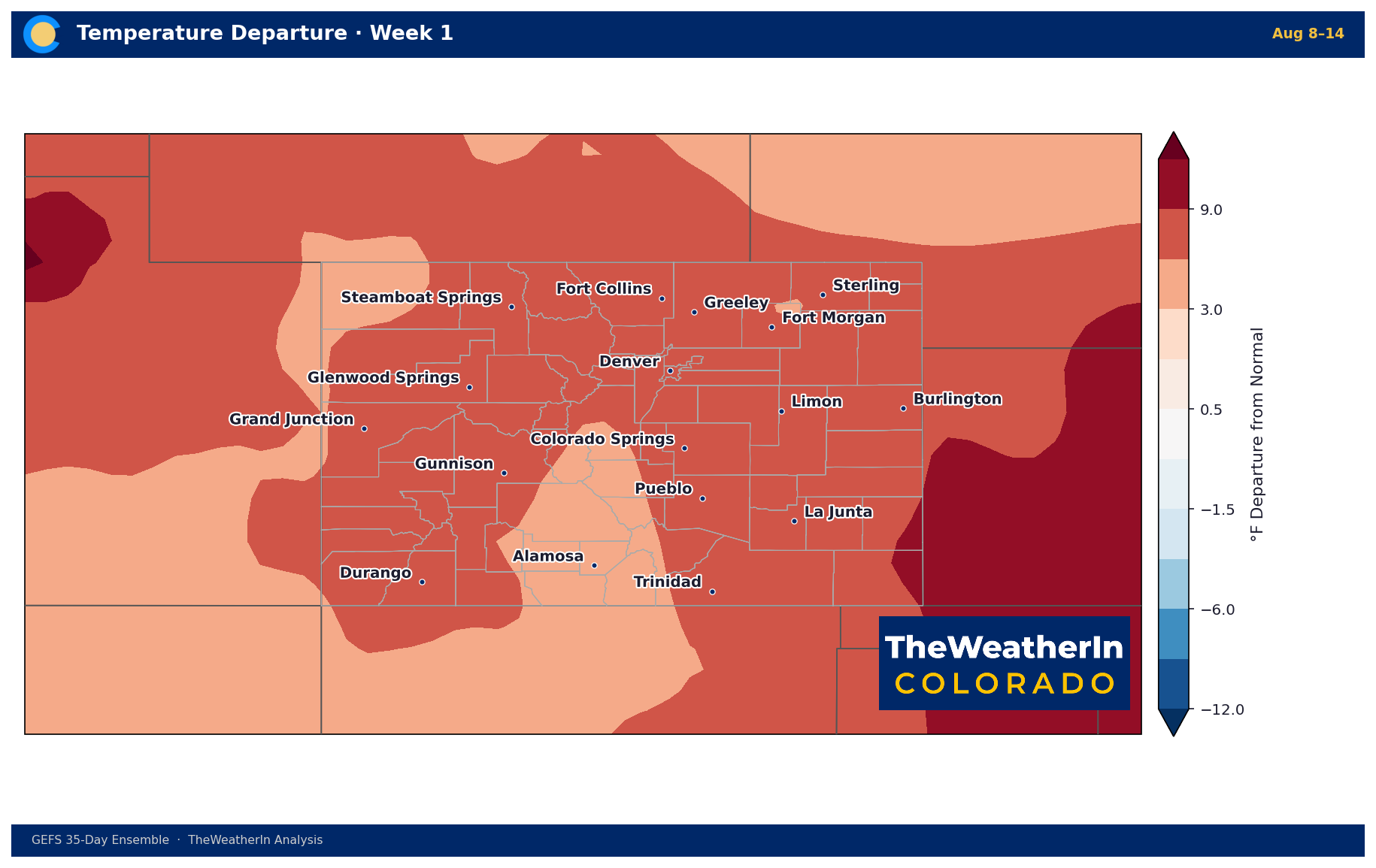
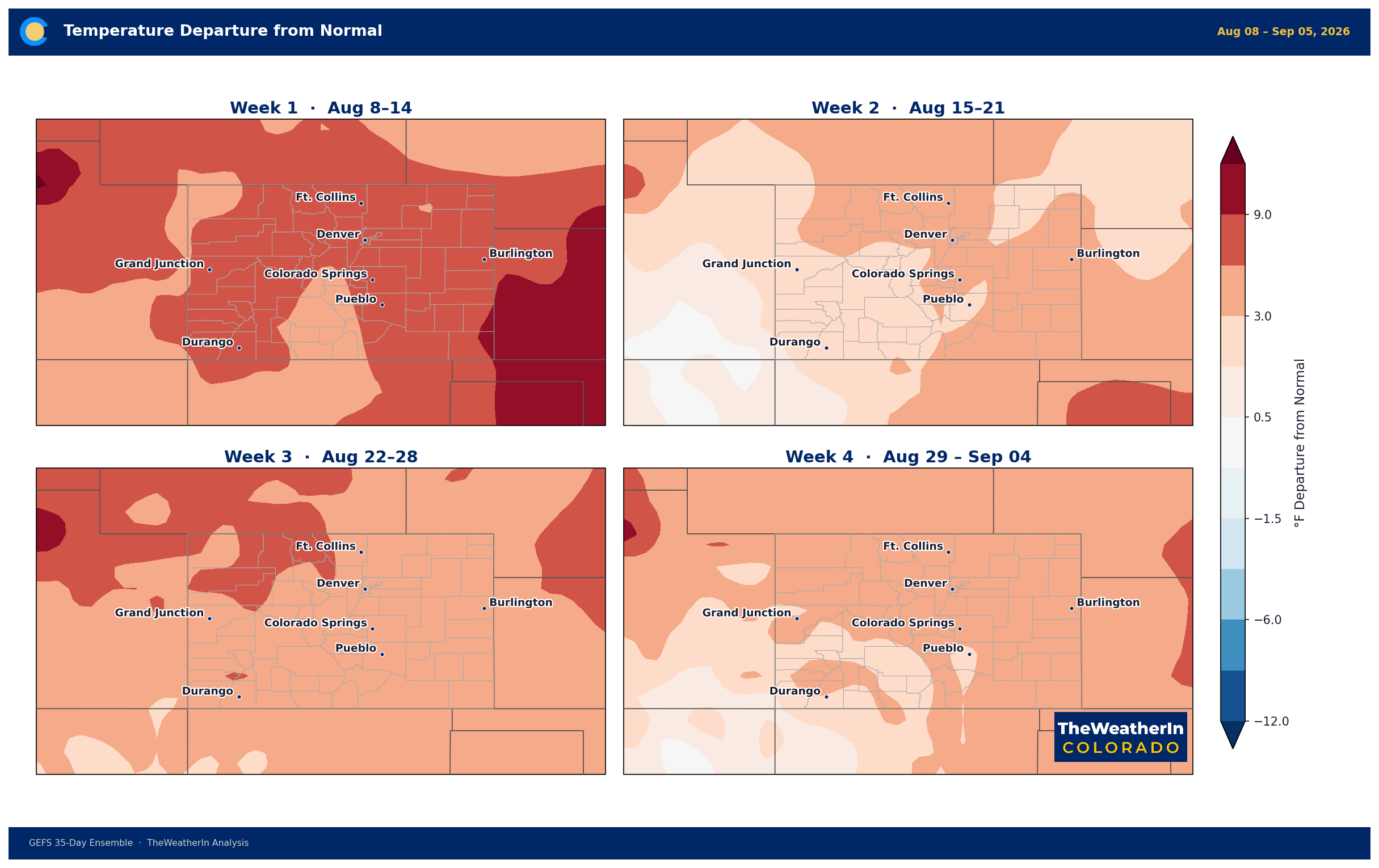
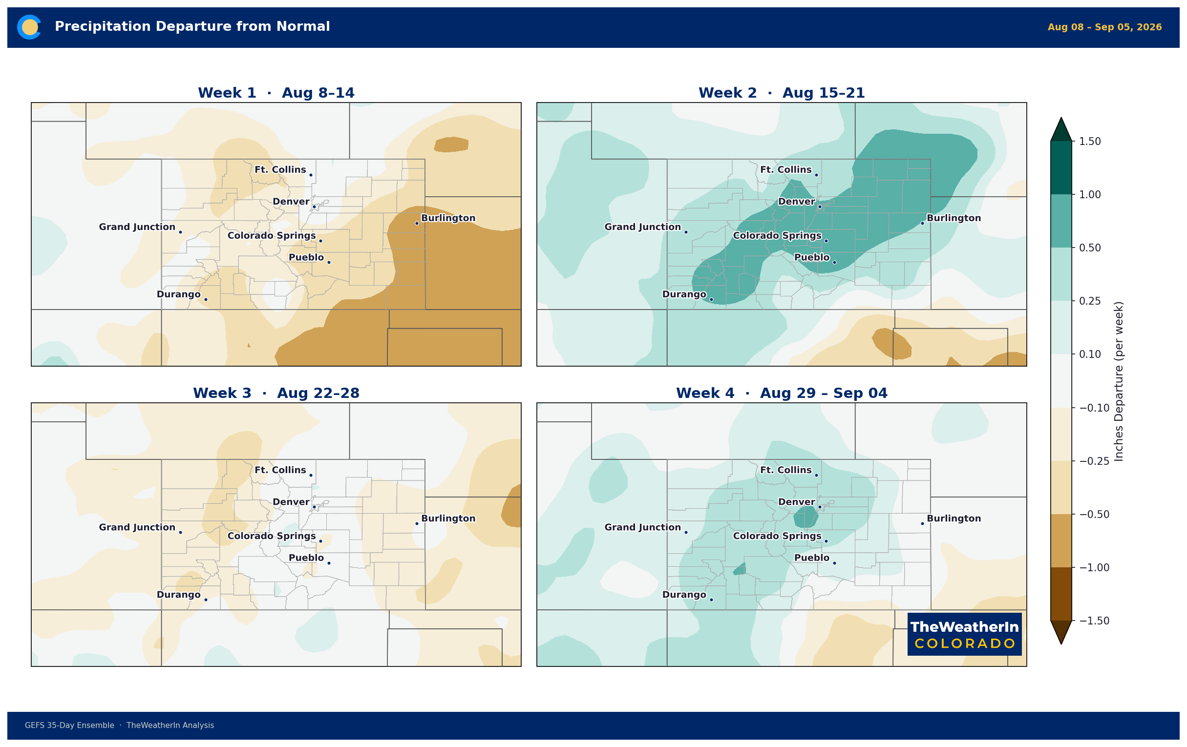
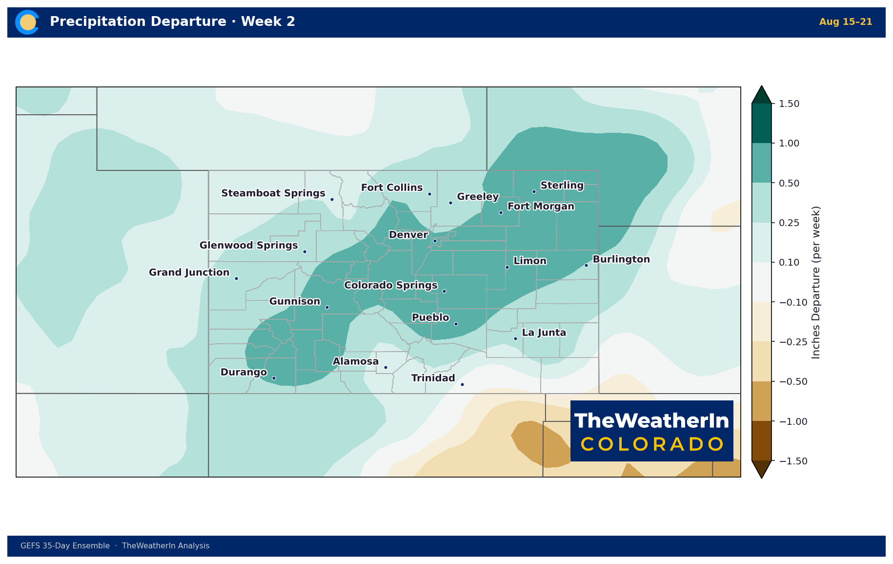
The mid-week monsoon break is real, but it is likely temporary. Forecast data through the Aug. 16–22 window shows subtropical ridging rebuilding across the south-central and southeastern United States — a signal that the heat returns, though not necessarily to this week's extreme levels. For Colorado, that means a brief window of cooler, wetter conditions mid-week gives way to a warming trend heading into the third week of August. Monsoon moisture is expected to linger through the period, maintaining a risk of afternoon and evening thunderstorms and continued flash flood concerns, particularly over burn scars and already-saturated soils.
Beyond week two, confidence drops sharply on storm placement and temperature extremes — but the broad signal is a return to a warm, drier-than-normal tendency into late August, with the active monsoon pattern remaining volatile rather than locked in. The one forward-looking thread worth tracking: a strengthening El Niño in the tropical Pacific is now on track to become one of the strongest events on record by late fall. That development has no bearing on Colorado's summer pattern — El Niño's influence on the southern Rockies is a winter story — but it represents the most important longer-range variable for drought recovery heading into 2027.
Regional Breakdown — Week Ahead (Aug. 10–16)
| Region | Temperature | Precipitation | Highlights |
|---|---|---|---|
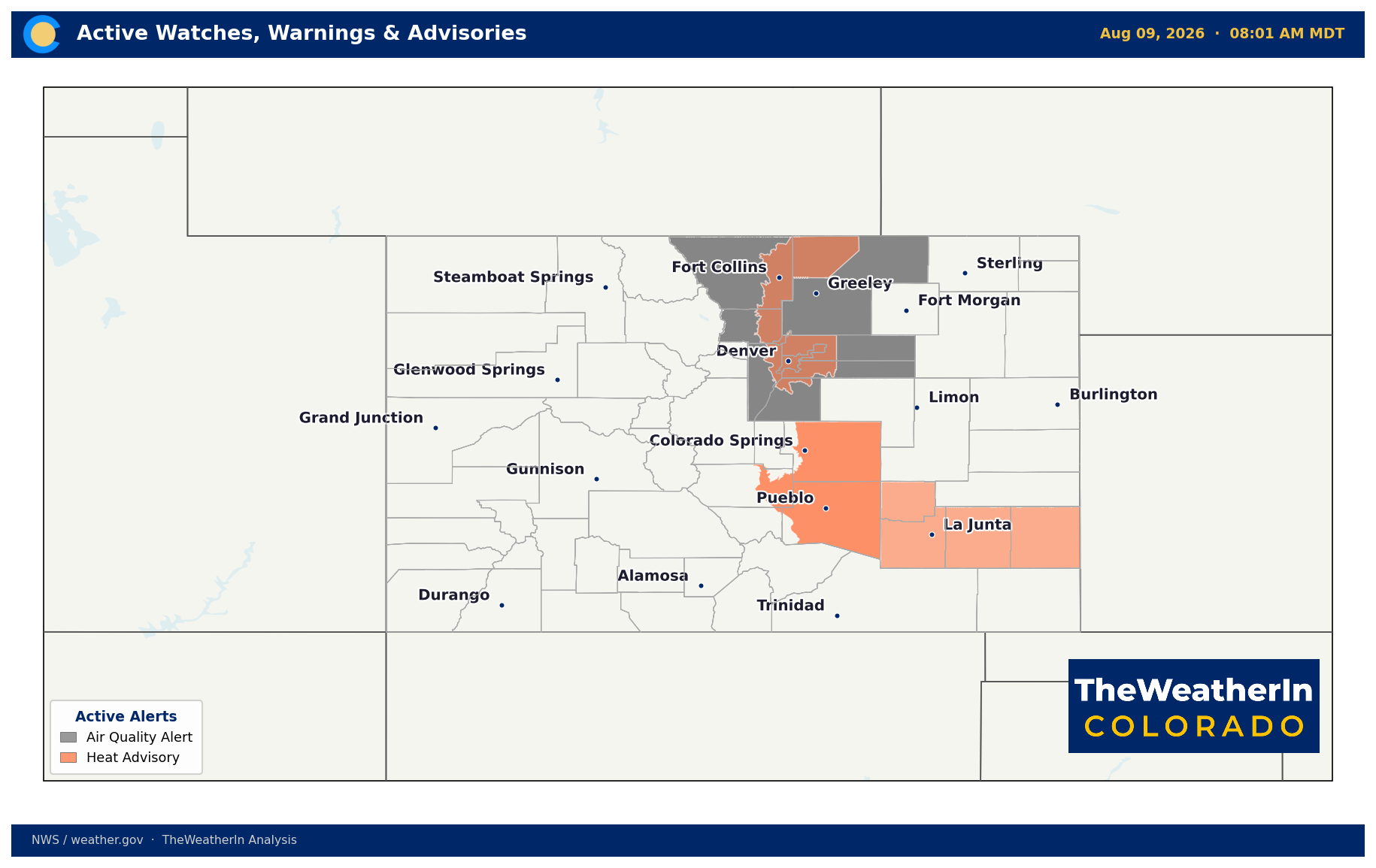
| Front Range / Foothills | Mid–upper 90s Sun–Tue; mid-80s by Thu | Near zero Sun–Tue; increasing Thu–Fri | Heat Advisory in effect through Sunday evening; gusty outflow winds 30–45 mph daily; heavy rain and flash flood risk returns Thursday |
| Mountains / High Country | Upper 80s–low 90s in valleys Sun–Tue; lower 80s by Wed | Minimal Sun–Tue; numerous storms Thu–Sat | Outflow gusts 20–45 mph early week; locally heavy rain late week; flash flood watch likely over burn scar drainages |
| Western Slope | 85–95°F at valley floor Sun–Tue; cooling mid-week | Isolated early; widespread and wetting mid-to-late week | Outflow gusts to 45+ mph Sunday–Tuesday; best chance for measurable monsoon rainfall arrives Wednesday–Friday |
| Eastern Plains | Mid-90s to 100°F+ Sun–Tue; mid-80s–low 90s Thu | Virga and outflow only Sun–Tue; heavy storms possible Thu–Fri | High-based storms produce damaging winds with little rain early week; flash flood risk and locally heavy rainfall late week |
| Southern CO / San Luis Valley | Upper 90s to 108°F Sun–Tue; Heat Advisories in effect | Isolated early; widespread Thu–Sat with heavy totals possible | Hottest temperatures in the state Sunday–Tuesday; Aspen Acres and 24 Fire burn scars under elevated flash flood and debris flow risk Wednesday onward |
Drought & Water
As of the August 4 U.S. Drought Monitor update, 97.3 percent of Colorado remains in at least abnormal dryness (D0 or worse), with 90.9 percent in moderate drought (D1) or worse, and 47.1 percent in extreme-to-exceptional drought (D3–D4). Exceptional drought (D4) — the highest category — covers 13.5 percent of the state. The Drought Severity and Coverage Index stands at 327, more than double its value a year ago and near the highest reading this drought cycle has produced.
One notable trend in the most recent data: D3–D4 coverage has pulled back slightly from its peak, with the D3-plus footprint contracting from 50.8 percent three weeks ago to 47.1 percent now, and D4 from 13.9 percent to 13.5 percent. That is a marginal improvement, not a recovery — but it suggests some localized benefit from the earlier monsoon pulse. The late-week storm system could continue that trend in pockets, particularly if storms are slow-moving and locally heavy. However, streamflows across every major Colorado river basin remain at or near all-time record lows for this point in the season. The Arkansas River at Salida, the Colorado River at Cameo, and a half-dozen other gauges with 90 to 130 years of data are tracking at or just above their historical minimum records. Reservoir storage is drawing down on carryover with no significant mountain runoff replenishment coming.
The drought emergency remains in effect statewide. No meaningful drought recovery is possible from summer convection alone — the signal that matters most for that story is a strengthening El Niño that now carries an 81 percent chance of reaching very-strong intensity by October–December 2026, historically one of the most favorable configurations for above-normal winter precipitation across the southern Rockies. That relief, if it arrives, is still four to five months away at minimum.
Agricultural Implications
- Heat stress and livestock: Extreme heat through Tuesday — up to 108°F in southern Colorado — demands active livestock management. Shade, water access, and reduced handling or movement during peak afternoon heat are essential through at least Monday. Overnight lows are running well above normal, limiting recovery time for both animals and outdoor workers.
- Late-week storms — opportunity and hazard: The monsoon surge Wednesday through the weekend brings the best chance of meaningful soil moisture recharge since early summer. Locally heavy totals are possible, but distribution will be uneven — some fields may see an inch or more while neighboring areas stay dry. Flash flooding and runoff on drought-hardened soils are also a concern: dry, crusted ground sheds water quickly rather than absorbing it, which limits the agronomic benefit even when totals look impressive on paper. Producers near the Aspen Acres and 24 Fire burn scars should be on alert for debris flows and erosion through the weekend.
- Forage and pasture outlook: Even if late-week precipitation is locally significant, native pasture recovery will be slow given the cumulative moisture deficit. The broader water supply picture — near-record-low streamflows, depleted soil profiles, a statewide drought emergency — does not improve materially from one monsoon event. The longer-range case for drought relief remains tied to what winter brings, and that in turn depends on how strongly El Niño develops over the next two to three months.
The signal to keep watching: whether the strengthening El Niño delivers the above-normal winter precipitation the southern Rockies needs — that is the hinge point for Colorado's water supply story heading into 2027.



