
Monsoon Relief Arrives — But the Drought Story Is Far From Over
Heavy rain and flash flood watches dominate Colorado mid-week, but the same ridge driving this summer's drought reasserts itself by the weekend. Here's what the next month looks like.

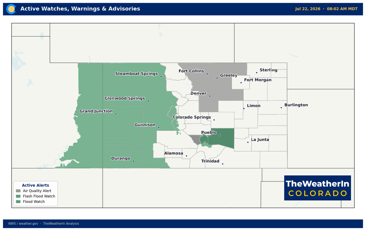
The most significant burst of monsoonal moisture in weeks is washing over Colorado right now — but the ridge that's been running this summer's story is already waiting in the wings. Before the week is out, heat returns, drought-parched fuels dry back down, and the pattern that has defined 2026 reasserts itself through at least early August.
Pattern Overview
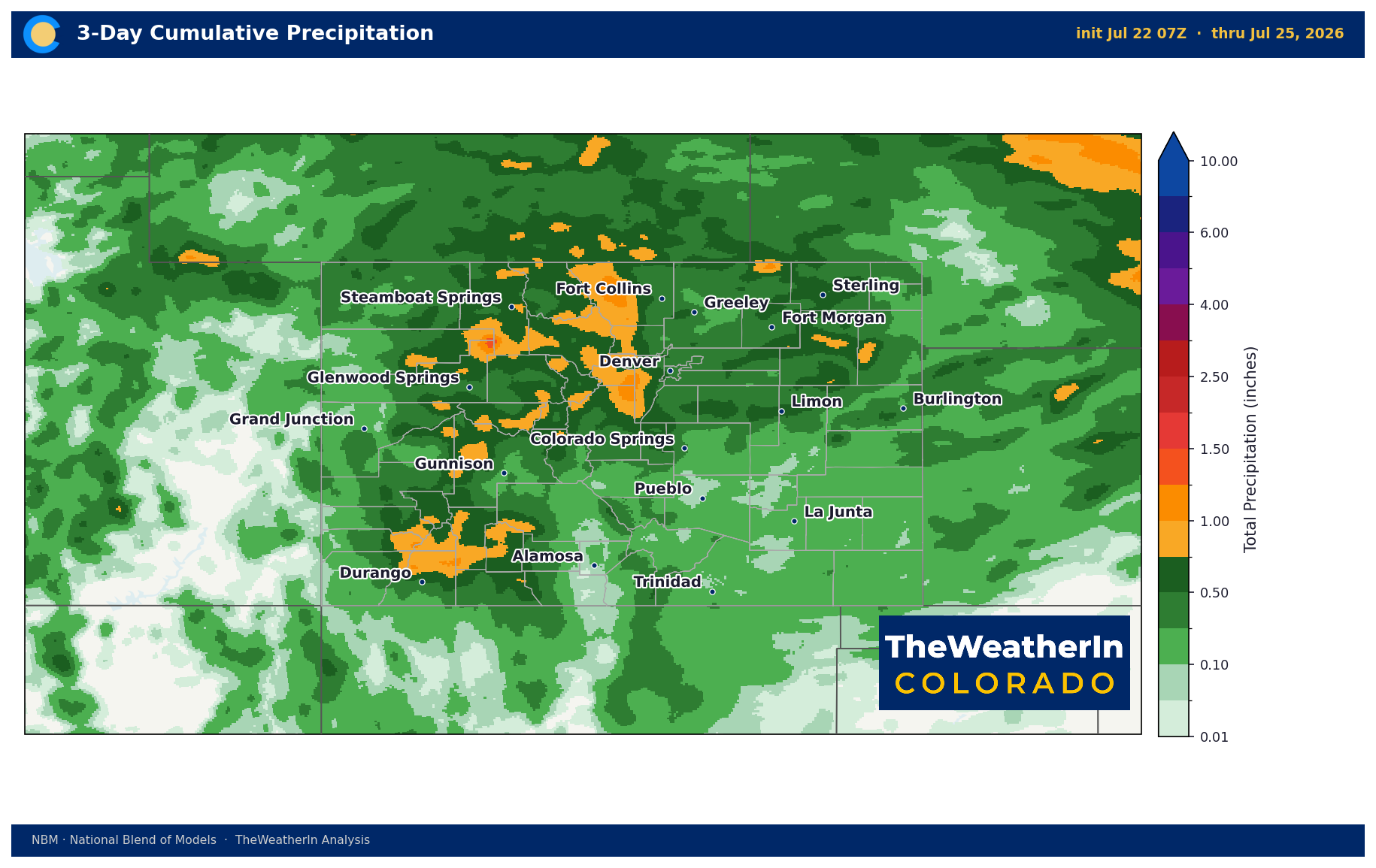
A persistent upper-level high-pressure ridge has anchored heat and drought across the West all summer, but an anomalous surge of monsoonal moisture from the Gulf of Mexico — precipitable water values running at 150–200% of normal — has found its way into Colorado's mountains and burn-scar terrain this week. The result is a brief, wet window Wednesday through Friday, with widespread showers and thunderstorms, locally heavy rainfall rates of 1–2+ inches per hour, and a welcome but temporary break from the heat. After Thursday evening, the ridge rebuilds and high temperatures return to the upper 90s across the plains by the weekend and triple digits in some locations next week.
The timing matters. Colorado's drought footprint is historically severe — as of July 14, 97% of the state remains in at least abnormal dryness, with 90% in moderate drought or worse. The monsoon can deliver localized relief to high terrain and individual watersheds, but it cannot reverse a statewide water supply deficit that traces back to the worst snowpack on record. This week's rains are welcome and meaningful for fire weather and short-term soil moisture. They are not a reset.
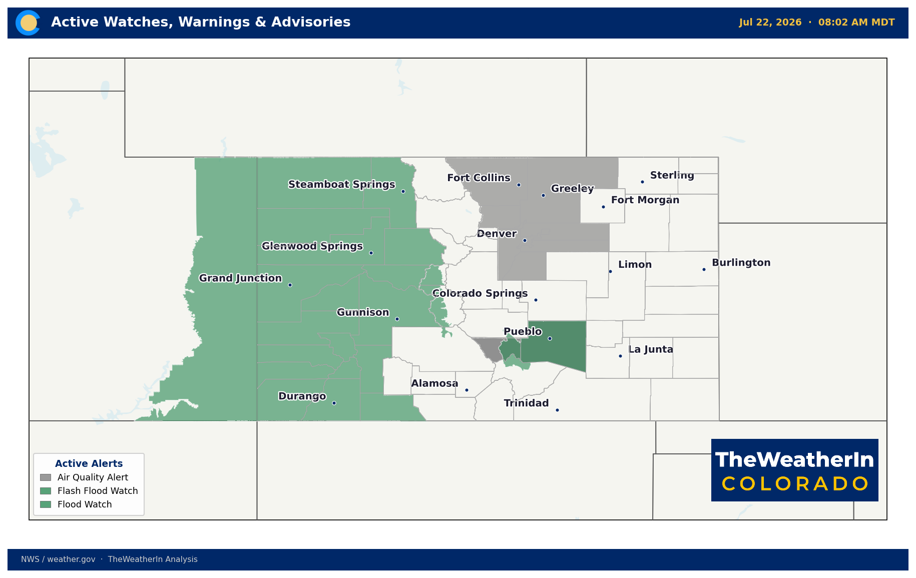
Critically, the burn-scar terrain scattered across the state — the Willow, Aspen Acres, Ferris, and Gold Mountain burn areas among them — presents a significant flash flood and debris-flow hazard this week. When heavy rain falls on recently burned slopes, the soil can't absorb it the way intact ground cover would. What's a beneficial soaking for unburned hillsides can become a fast-moving debris flow on a burn scar. Flash Flood Watches are active, and they should be taken seriously through at least Friday.
Weeks Ahead: 2–4 Week Outlook
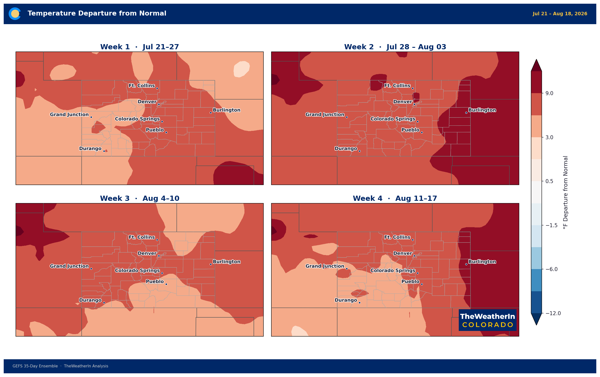
The near-term relief gives way to a pattern that is expected to persist through the first week of August and likely beyond. The same blocky, amplified upper-level setup that has driven Colorado's brutal summer — a warm ridge centered over the Intermountain West and Rockies, troughs parked off both coasts — is forecast to hold firm through at least July 29–August 4, with only a gradual weakening trend and no significant pattern-flip on the horizon. That translates to continued heat, especially across the Southwest and Southern Plains, with the Eastern Plains and San Luis Valley likely seeing temperatures running 6–8°F above normal or more during this period.
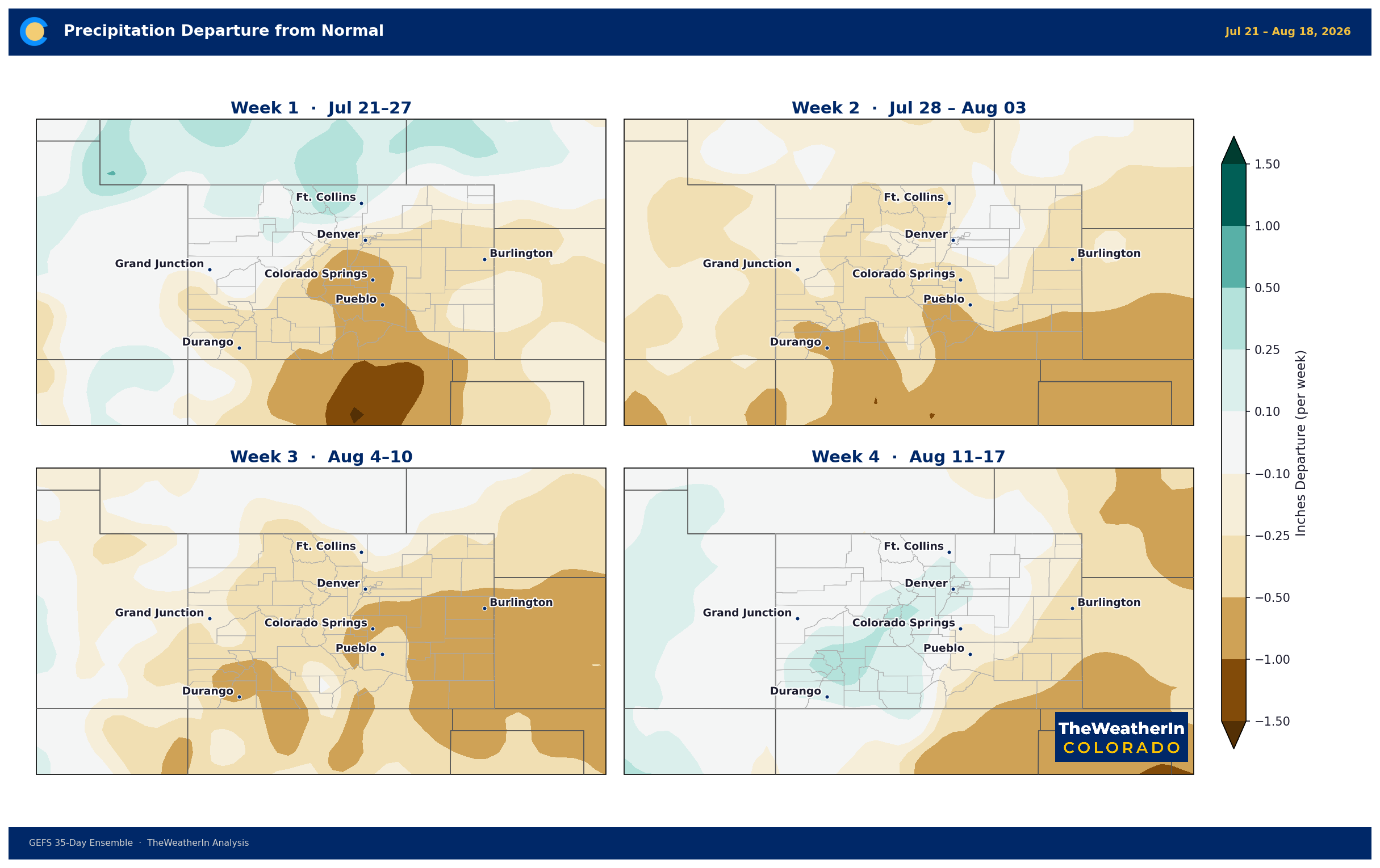
The monsoon may remain locally active over the Four Corners, offering scattered afternoon storms at higher elevations — but as the ridge tightens through early August, the frequency and coverage of monsoon moisture into Colorado is expected to decrease, not increase. The window for meaningful precipitation relief is narrowing, not widening. Fire weather risk will return quickly Friday through the weekend as humidity crashes and temperatures soar, with fuels drying out nearly as fast as this week's rains moistened them.
Looking further out, the signal worth watching is El Niño. The strengthening tropical Pacific pattern now carries an 81% chance of reaching very-strong intensity by October–December 2026 — among the strongest events on record. Historically, that kind of event delivers above-normal precipitation to the southern Rockies during winter. That's a meaningful forward-looking signal for Colorado's drought — but it's a winter story. It won't arrive until November at the earliest, and it cannot replace what the 2025–26 snow season never delivered. The summer pattern is still being set by the ridge, not El Niño.
Regional Breakdown — Week of July 22
| Region | Temperature | Precipitation | Highlights |
|---|---|---|---|
| Front Range / Foothills | Near 90°F Wed → mid-80s Thu → upper 90s by Sat | Best rain chance Wed–Thu; dry Friday onward | Denver convergence-zone storms late Wed afternoon; outflow winds 30–50 mph possible; heat rebounds fast by weekend |
| Mountains / High Country | 70s–80s through Friday; warming slightly weekend | Heaviest rainfall Wed–Thu; 1–2+ in/hr possible; more isolated Sat–Sun | Burn-scar flash flood risk is the primary hazard; widespread lightning; activity becomes scattered by weekend |
| Western Slope | 85–95°F Wed → high 70s–mid-80s Thu → warming Fri–weekend | Scattered to widespread showers Wed–Thu; debris-flow risk over Willow, Ferris, Gold Mountain burn scars | Moisture peaks Wed–Thu morning; terrain-driven storms return Friday; weekend trends drier with isolated mountain showers |
| Eastern Plains | Near 95°F Wed → high 80s Thu → triple digits possible by weekend | Mostly dry; scattered storms possible along outflow boundaries Wed evening; isolated Thu with cold front | Marginally severe storm threat Wed–Thu (large CAPE, low shear); dry Friday onward; rapid heat rebound |
| Southern CO / San Luis Valley | Mid-90s on plains Wed → dip Thu → triple digits Fri–Sun; mountains 70s–80s | Best storm coverage Thu over mountains and San Juans; Aspen Acres burn scar under high flash-flood risk Thu–Fri | Willow and Chalk Cliffs burn areas under Flash Flood Watch; scattered activity continues Friday; weekend dries out |
Drought & Water
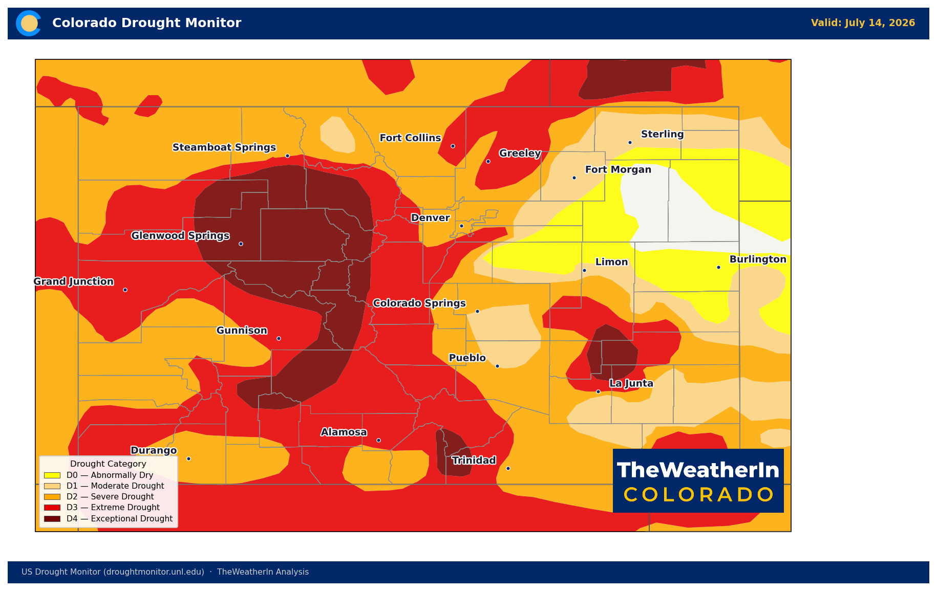
Colorado's drought picture improved marginally on the July 14 U.S. Drought Monitor — the first week-over-week decrease in statewide drought coverage in months. The share of Colorado in at least abnormal dryness eased slightly from 98.3% (July 7) to 97.1% (July 14), and moderate drought or worse dropped from 91.1% to 90.3%. Exceptional drought (D4) — the most severe category — ticked up from 10.0% to 12.2%, concentrated in the most severely impacted burn-scar and water-stressed areas. The Drought Severity and Coverage Index (DSCI) held steady at 325, unchanged from the prior week, and remains more than double its value from a year ago.
This week's monsoon rains will provide localized relief to high terrain and burn-scar areas and may result in some spot improvement on next week's Drought Monitor — particularly in the mountains and Western Slope where coverage is most widespread. But the state's drought was not built in a week, and it will not be broken by one either. The underlying water supply deficit is structural: statewide May–July runoff is forecast at just 24% of median, with multiple rivers posting all-time or near-record low flows for this point in the year. Reservoir carryover from 2025 is sustaining many water users through summer — but that storage is being drawn down with no meaningful snowmelt replenishment behind it. The path to genuine drought recovery runs through a winter with significantly above-normal mountain snowpack — and that window is still four to five months away at minimum.
Fire weather risk will return quickly. Fuels across the burn scars and eastern plains are critically dry, and the same rains bringing flash flood watches today will have little lasting effect on fuel moisture once the ridge rebuilds Friday. Expect fire weather conditions to return to the eastern plains, San Luis Valley, and southern mountains by this weekend.
Agricultural Implications
- Brief heat relief, then rapid return: Wednesday and Thursday offer a genuine respite — cooler temperatures, improved humidity, and reduced UV stress provide a window for livestock and heat-stressed crops. It's short. Upper 90s return to the plains by Saturday and triple digits are possible on the Eastern Plains and San Luis Valley by next week. Plan heat-stress management accordingly; the relief window is 48–72 hours, not a pattern change.
- Wind and crop damage risk: Thunderstorm outflow winds of 30–50 mph are possible Wednesday afternoon through Thursday evening. Lodging risk for corn and other tall-canopy crops is real, particularly along and east of the I-25 corridor and Western Slope valleys where storms are most likely to be organized. The most dangerous window is Wednesday late afternoon into Thursday evening.
- Burn-scar and soil erosion risk: Producers with land near active burn scars — particularly in the Willow, Aspen Acres, Ferris, and Gold Mountain areas — face elevated runoff and debris-flow risk through Friday. Previously saturated soils on the Western Slope are also at elevated erosion risk under high rainfall rates. The longer-range picture remains one of continued heat and drought stress through August, with the next meaningful season-level shift not expected until El Niño's typical winter precipitation signal arrives — November at the earliest.



